Patrick Stotz

534 Followers
170 Following
106 Posts
πŸ’ΌCo-lead data journalism & graphics at DER SPIEGEL
πŸ—ΊοΈ Blogging about maps at letsmakeamap.com
workhttps://www.spiegel.de/duv
blog / map shophttp://letsmakeamap.com
And finally, you can download my maps here for a few bucks:
www.letsmakeamap.com/shop
Or just follow the blog post and build your own.
Huge thanks by the way to @awoodruff and the guys at Axis Map back then, whose tools I've used to make the maps. Always great to see tools survive that long.
One benefit of this hobby: you've always got a personal birthday gift at your fingertips.

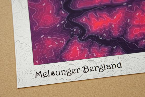
New blog post: How to make colorful contour maps:
https://www.letsmakeamap.com/blog/lets-make-contour-maps

#maps #QGIS #design

Let’s make contour maps β€” Let's make a map

How to make colorful contour maps with nothing but elevation data. Covering the whole process from finding data to designing the map in QGIS and publishing it.

Let's make a map
Let's make some colorful maps this time
Rafael #Nadal at the French Open:
βœ…βœ…βœ…βœ…βœ…βœ…βœ…βœ…βœ…βœ…βœ…βœ…βœ…βœ…βœ…βœ…βœ…βœ…βœ…βœ…βœ…βœ…βœ…βœ…βœ…βœ…βœ…βœ…βœ…βœ…βœ…βŒβœ…βœ…βœ…βœ…βœ…βœ…βœ…βœ…βœ…βœ…βœ…βœ…βœ…βœ…βœ…βœ…βœ…βœ…βœ…βœ…βœ…βœ…βœ…βœ…βœ…βœ…βœ…βœ…βœ…βœ…βœ…βœ…βœ…βœ…βœ…βœ…βœ…βœ…βœ…βŒβœ…βœ…βœ…βœ…βœ…βœ…βœ…βœ…βœ…βœ…βœ…βœ…βœ…βœ…βœ…βœ…βœ…βœ…βœ…βœ…βœ…βœ…βœ…βœ…βœ…βœ…βœ…βœ…βœ…βœ…βœ…βœ…βœ…βœ…βœ…βŒβœ…βœ…βœ…βœ…βœ…βœ…βœ…βŒ
#dataviz

My figure-ground posters are also available for download on my blog. Just €8 per city/poster. Get yours, print it, frame it, use it as a wallpaper, whatever you like. πŸ—ΊοΈ

https://www.letsmakeamap.com/maps/buildings-of-x

Buildings of X - Beautiful figure-ground diagrams for cities worldwide. β€” Let's make a map

Individually designed map posters of Amsterdam, New York, Beijing and many cities more available in the shop for download.

Let's make a map

Just published the 3rd and final part of my series on figure-ground diagrams.

It's about organizing the project and the finishing touches to turn the maps into beautifully designed posters.

#maps #design #gis #cartography

https://www.letsmakeamap.com/blog/how-to-make-figure-ground-diagrams-part-3-turn-your-map-into-a-poster

How-to make figure-ground diagrams: Part 3 - Turn your map into a poster β€” Let's make a map

Final part of my series on how to make figure-ground diagrams. Dealing with how to organize your QGIS project, exporting map views and finally turning them into beautifully designed posters.

Let's make a map
If you want to stay up-to-date, what I'm building check out
- letsmakeamap.com/blog
- subscribe to the newsletter on my website or
- via plain old RSS: letsmakeamap.com/blog?format=rss

New blog post: How-to make figure-ground diagrams: Part 2 - Styling your map

https://www.letsmakeamap.com/blog/how-to-make-figure-ground-diagrams-part-2-styling-your-map
#maps #gis #cartography

How-to make figure-ground diagrams: Part 2 - Styling your map β€” Let's make a map

On the process of styling figure-ground diagrams using QGIS, focusing on design choices for buildings, roads and water bodies. Covering details like color choices, subtle shades, and the use of effects like shapeburst fill when designing your map.

Let's make a map