453 Followers
169 Following
313 Posts
The mission of the Cartography and Geographic Information Society is to support research, education, and practice to improve the understanding, creation, analysis, and use of maps and geographic information to support effective decision-making and improve the quality of life. The society serves as a forum for the exchange of original concepts, techniques, approaches, and experiences by those who design, implement, and use cartography, geographical information systems, and related geospatial tech
websitehttps://cartogis.org
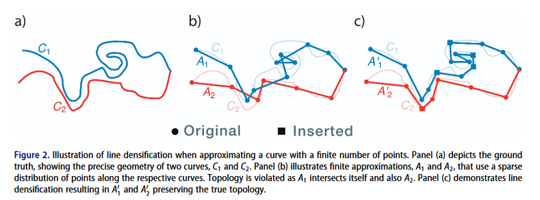
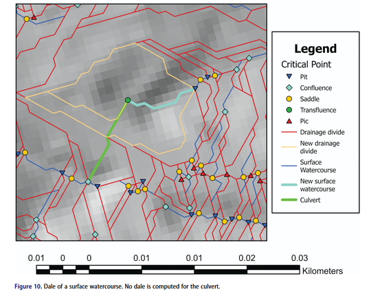
New article! Yassmine Zada, Eric Guilbert and Sylvain Jutras explore how to integrate culverts into drainage network mapping without altering the underlying digital terrain model (DTM) https://doi.org/10.1080/15230406.2026.2633277 #GISchat

CaGIS is pleased to announce the winners of the 53rd annual CaGIS Map Design Competition!

All winners and honorable mentions are listed here: https://cartogis.org/docs/map_competition/CaGIS_Map_Design_Competition_Results_2025.pdf

And the gallery of images of the maps is here:
https://cartogis.org/awards/map-competition/gallery/#2025

Thank you to everyone who participated in the competition! We look forward to next year's entries!

CaGIS Volume 52 Issue 2, our special issue on Smart cartography for sustainable development: International Cartographic Conference 2023 is now available online and the printed copy should be on its way to all our subscribers! https://www.tandfonline.com/toc/tcag20/53/2 #GISchat We have 5 amazing papers including rainbow color schemes, semantic segmentation of historical maps, X-ray vision-enabled mixed reality, geoAI ethics and animated transitions on multiscale thematic maps. Check out the thread below:

The March 15 deadlines for submission of extended abstracts, entries for the student paper competition, vision papers, and workshop proposals for the 2026 CaGIS Conference have been extended to April 1 (No fooling!).

See https://cartogis.org/conferences/cagis2026/call-for-participation/ for details.

Also, if you are interested in becoming a sponsor for the conference, see the sponsorship prospectus here: https://cartogis.org/docs/conferences/CaGIS_2026/CaGIS%20Conference%202026%20Sponsorship%20Prospectus.pdf

Have a great weekend!

Call for Participation – Cartography and Geographic Information Society

New article! Fantastic work from Nihal Z. Miaji and colleagues on the cartogram creation process, and how we ensure topology is preserved and cartogram regions remain connected and not overlapping https://doi.org/10.1080/15230406.2026.2625329 #GISchat #OpenAccess