453 Followers
169 Following
313 Posts
The mission of the Cartography and Geographic Information Society is to support research, education, and practice to improve the understanding, creation, analysis, and use of maps and geographic information to support effective decision-making and improve the quality of life. The society serves as a forum for the exchange of original concepts, techniques, approaches, and experiences by those who design, implement, and use cartography, geographical information systems, and related geospatial tech
websitehttps://cartogis.org
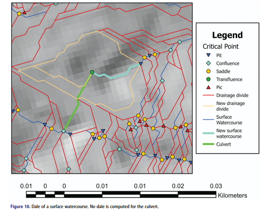
New article! Yassmine Zada, Eric Guilbert and Sylvain Jutras explore how to integrate culverts into drainage network mapping without altering the underlying digital terrain model (DTM) https://doi.org/10.1080/15230406.2026.2633277 #GISchat
CaGIS Volume 52 Issue 2, our special issue on Smart cartography for sustainable development: International Cartographic Conference 2023 is now available online and the printed copy should be on its way to all our subscribers! https://www.tandfonline.com/toc/tcag20/53/2 #GISchat We have 5 amazing papers including rainbow color schemes, semantic segmentation of historical maps, X-ray vision-enabled mixed reality, geoAI ethics and animated transitions on multiscale thematic maps. Check out the thread below:
New article! Fantastic work from Nihal Z. Miaji and colleagues on the cartogram creation process, and how we ensure topology is preserved and cartogram regions remain connected and not overlapping https://doi.org/10.1080/15230406.2026.2625329 #GISchat #OpenAccess
New article! Wenwu Tang and colleagues present A web-based spatial decision support system of COVID-19 wastewater surveillance on a university campus https://doi.org/10.1080/15230406.2026.2629334 #GISchat
New article! Hua Liao and colleagues evaluate how much we can deduce from users visual behaviour in pedestrian navigation: quite a bit it seems, including gender, geographical expertise, spatial ability and familiarity of the environment #GISchat https://doi.org/10.1080/15230406.2026.2619028 Data at https://figshare.com/s/5b06a12beae19a479aab
New article! Ben Ma and colleagues evaluate how mid-air gestures could be used to interact with mobile maps, https://doi.org/10.1080/15230406.2026.2619027 #GISchat Data available at https://doi.org/10.6084/m9.figshare.30833309
New article! Anni Simola and colleagues proposed a quality assessment framework for PPGIS data and test it with three example data sets, comparing it with OpenStreetMap as reference data https://doi.org/10.1080/15230406.2026.2616453 #GISchat #OpenAccess
New article! Yue Chen and colleagues look at how we can apply continuous multi-scale transformation of building footprints that will be useful in dynamic zooming in web maps, like in the example below https://doi.org/10.1080/15230406.2026.2618208 See also their data at https://doi.org/10.6084/m9.figshare.25866664.v1
New article! Zhekun Huang, Haizhong Qian and colleagues explore and evaluate new ways of matching contours from multiple sources of terrain data using unsupervised learning https://doi.org/10.1080/15230406.2025.2589374 Data https://doi.org/10.6084/m9.figshare.28844162.v1 Code https://gitee.com/zhekunhuang/coutour-match #GISchat
New article! Nianhua Liu, Yu Feng and colleagues look at Trust in Climate Change Communication, including the impact of having just a map or a photo included, or just a headline #GISchat #OpenAccess https://doi.org/10.1080/15230406.2025.2604671 Data at https://figshare.com/articles/dataset/Understanding_Trust_in_Climate_Change_Communication/29145266