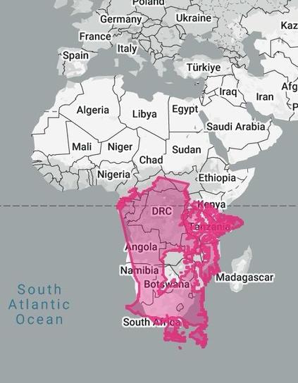
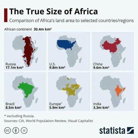
Africa is BIG
@infobeautiful It is worth saying that you can do your own versions of these with the splendid TheTrueSize website:
@infobeautiful P.S. Use the trashcan button to remove existing countries and clear the map.
Use the compass rose to spin your selected country to help it to fit better.
:-)
We recently had visitors from Namibia so I was curious to see how we fit there.
@infobeautiful Well, it is a continent, after all. The U.S. just has some folks running it who think we are, too.
Which is the best explanation I've got for his obsession with Canada, Mexico, as well as all of Central and South America.
And the USA?
We need to start using a world-map that does not change sizes of the continents.
Why would you do that? If size matters the most (for someone it looks it does) probably an histogram with country areas in km² would be best. If it's confusion about spatial placement of continents that you seek, then that map is great.
However for Africa comparison, I agree it's incredibly huge. But if it is for fairness, it would be fair to compare apples with apples. Not countries with continents. Yes, Europe comes out the tiniest fly both as a political entity and as a continent anyway you look at it.
@77nn @infobeautiful Why are you calling Africa a continent.
I am from the continent of Afroeurasia.
@RavenPunk The areas listed are reasonably accurate.
Asia is the largest continent, and Russia the largest country. But compared against the continents, Russia ranks behind Africa, North America, and South America.
@infobeautiful The Brazil one reminds me of Al Gore's joke
The Harvard Crimson:
He recalled a time in the sixth grade when a classmate pointed to the east coast of South America and the west coast of Africa and asked if they had ever fit together. The teacher said that was not the case
“The student went on to become a drug addict,” he joked. “And the teacher went on to become a scientist in the Bush administration.”
@ienvision @infobeautiful with the exceptions of Europe and East Poland, yes indeed!
did you have a better way to visually demonstrate the size of Africa relative to high-familiarity geographic areas? I would love to see and boost it.
The USA is (at this moment) incontinent.
Africa Is Not A Country FFS. 😡
@infobeautiful Why does it say excluding russia if russia is there? 🤔
Update: its an asterisk for Europe. Thank you!
@domo That footnote refers specifically to the comparison to Europe. Russia crosses the continental divide from Asia into Europe, with some 4.1mil km2 on the European side.
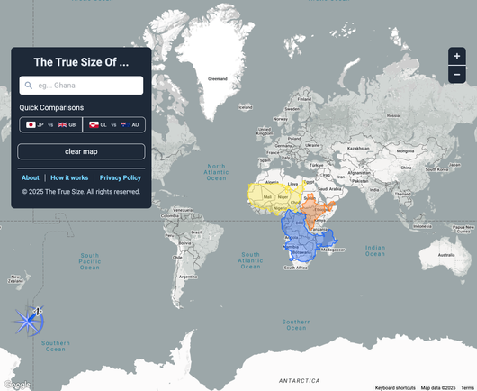
Drag, drop and rotate countries, states, provinces, and regions around the map to compare their relative size. Is Greenland really as big as all of Africa? You may be surprised at what you find! A great tool for educators.
Where is the comparison to Canada?