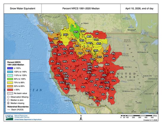
This is a frightening map, especially given the fact that this is normally near the peak in snowpack across the West. There are many far-reaching consequences from this historic snow drought, ranging from increasing risk of summer wildfires to major water concerns.

Map by https://nwcc-apps.sc.egov.usda.gov/

@ZLabe

The Canadian west is anomolous.

Near average overall but above average further north, well below in the south, which applies the major rivers to populated areas.

I particularly follow this because in 1981, my first ever IT job was in adapting the US Army's river modeling and flood forecasting programs for the Alberta government. Mainframe Fortran.

One of the main inputs was detailed snowpack data.

https://ca.news.yahoo.com/b-c-snowpack-reveals-sharp-165713791.html

@blogdiva

B.C. snowpack reveals sharp divide ahead of the spring melt

We break down the April snowpack levels in British Columbia, highlighting a significant divide across the province. While some regions are near normal...

Yahoo News Canada