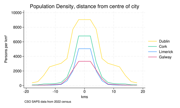
I saw this on Reddit, and having the data to hand, I thought I'd replicate it:
https://www.reddit.com/r/europe/comments/1s61cou/how_european_cities_stack_up_in_density/#lightbox
I saw this on Reddit, and having the data to hand, I thought I'd replicate it:
https://www.reddit.com/r/europe/comments/1s61cou/how_european_cities_stack_up_in_density/#lightbox
Interesting. Inner London surprised me, it’s remarkably similar to the peak central Dublin number but the curve is completely unlike the other European cities.
@bthalpin ok, fair enough.
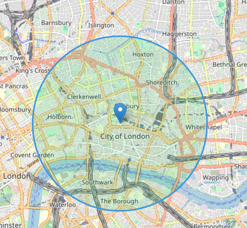
Do you know where the centre of dublin, used in the graph, is located?
I picked it myself, Ormond Quay, roughly centre of the central district.
https://www.openstreetmap.org/search?query=53.346211%2C+-6.266037&button=#map=15/53.34621/-6.26604
@bthalpin cool!
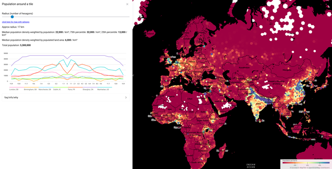
i keep seeing these on the bird site
a few years ago i made a janky map for finding the population weighted population density (imo a vastly superior measure because it tells you what people experience) around a point in europe
https://o.blanthorn.com/population-around-a-tile/map/
i am hoping if i see enough of these graphs it'll make me jealous enough to go back and finish my rewrite of it
@bovine3dom Go for it!
This is based on (very) small area statistics (avg popn 260ish); yesterday I was looking for similar data for France and found your IRIS map: very neat, I'll be spending lots more time with it!
@bthalpin oh, neat! that's another project that i think has a lot of potential - the idea was to do geospatial vis stuff from a dumb http server. i got fed up with finding articles that had dead links to arcgis hosted stuff that had been turned off after funding ran out
you might find https://data.humdata.org/m/dataset/kontur-population-dataset useful if you need a global dataset
it's the same base data that Tom Forth uses but reprojected to a more useful spatial index
@bthalpin i think i got nerd-sniped. you can shift click to compare places now (with the caveat that if you're not at the same zoom level you'll get nonsense)
a fair bit to clean up before i can replace the original url...