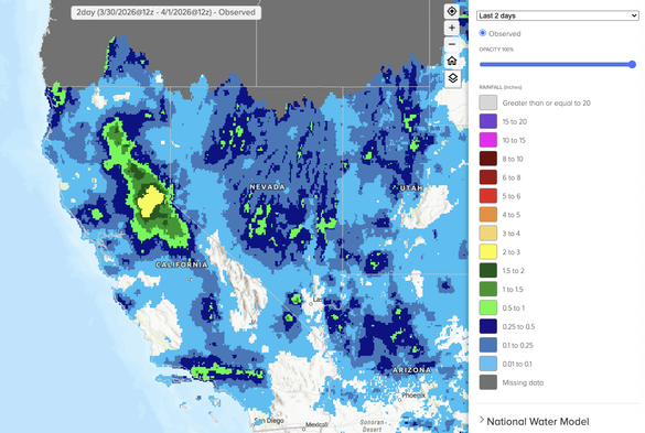
Well, I do have some good news to report: yesterday's weather system "overperformed" somewhat in NorCal! Convective activity and even some stronger thunderstorms developed in the unusually warm/moist/unstable airmass, bringing some more widespread downpours than expected.
A second, colder wave of precipitation is likely later today, and a few more thunderstorms are possible at lower elevations (along with somewhat lower elevation snowfall in the mountains, maybe including a couple inches down to ~Lake Tahoe level).
Overall, this is quite a welcomed reprieve from recent record-shattering heat and near-record March dryness. The Upper Colorado basin will see similarly more favorable conditions over next few days, as well. This precipitation will re-moisten mountain soils, and bolster runoff.
But from broader snowpack perspective, it's simply too little, too late. This week's cooler temperatures & mountain precipitation will allow snow water equivalent to flatline or even tick upward a few percentage points. But SWE will generally remain near or below record lows.
After this cooler & wetter interlude, there are once again strong signals than anomalous April warmth will dominate the West for much of rest of April. It won't be as extreme as March, relatively speaking, but return of warmth & dryness will likely allow rapid snowmelt to resume.