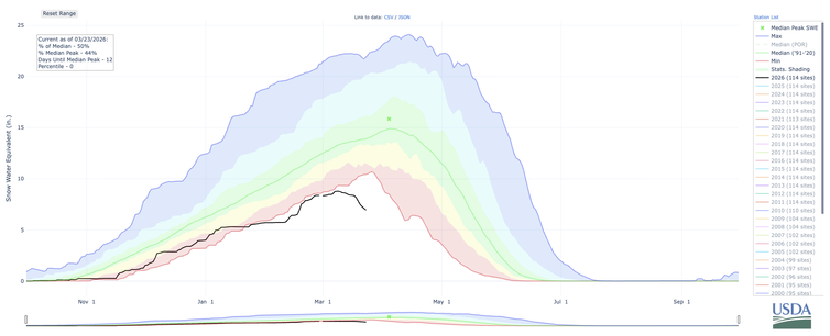
Amid the historic and ongoing record heatwave (which will continue for at least another week in this region), Colorado River Basin snowpack has unfortunately taken an unprecedented March nosedive. Given the pre-existing water crisis, this is a highly alarming trajectory.
I now believe it is likely that the West will face record-low April 1 snowpack concurrently across many watersheds concurrently. This year may also bring unprecedented divergence between precipitation & runoff due to record-shattering warmth and extreme evaporative demand.
While there may be some modest relief in early April in the form of cooler temperatures and some precipitation, it will be for all intents and purposes statistically and meteorologically impossible for a real recovery to happen between now and summer.
Some regions have more of a buffer than others. In California, and Washington State (as well as some parts of the Northern Rockies), the extreme snow drought does not translate to a severe hydrological drought at this time due to decent overall precipitation. However...
Even in these areas, anomalous warmth and historic snow drought will still lead to ecological and wildfire-related impacts as soon as this spring, and possibly wider water challenges by late summer and beyond.
But my main concern remains the interior West, especially Colorado River Basin. Here, there is a growing near-term risk (by later this spring and summer) of water supply and hydroelectric shortfalls, an early and intense fire season, and ecosystem degradation. This is a big deal.