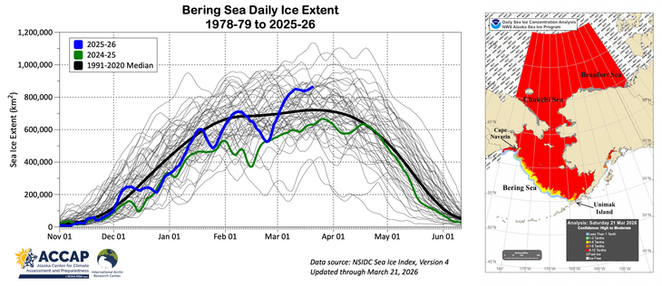
Sea ice extent in the Bering Sea is the highest since spring 2013, but it's not even in the top ten for the date in NSIDC data. That's because there's very little ice on the Russia side southwest of Cape Navarin. In the southeast Bering Sea ice extent extends to all the way to Unimak Island, making this similar to the extreme springs of 2012 and 1976. @Climatologist49 @ZLabe

#akwx #Arctic #SeaIce

@AlaskaWx @Climatologist49 @ZLabe

Thank you!
Could you also highlight 2012?
I am curious how the Bering Sea ice maximum in that year compares to 2026 because 2012 was the year with the bonkers sea ice loss.

@AlaskaWx @Climatologist49 @ZLabe

Oh, I just found Zack's Bering Sea daily ice extent with 2012 highlighted in orange
https://zacklabe.com/wp-content/uploads/2026/03/nsidc_sie_regionals_v2_lines-5.png

So in 2012, ice extent was exceptionally high in your neck of the wood.

And it naturally dropped to zero in summer – which made the sea ice loss exceptionally large.
Hm. Is that why 2012 was bonkers regarding Arctic loss in extent? Because it started with huge extent and had so much to lose?

@anlomedad @Climatologist49 @ZLabe No. 2012 was the lowest minimum Arctic-wide sea ice extent. Bering Sea ice extent is always zero by late June or July. Summer ice extent is dependent on what happens with ice north of 70ºN and especially north of 75ºN latitude. In August 2012 there was a very strong storm north of Siberia that caused rapid melt of a lot thin lower concentration ice.