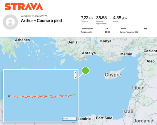
French aircraft carrier Charles de Gaulle tracked via Strava activity in OPSEC failure
As funny as that is, something tells me it’s not that hard to spot an aircraft carrier in the Mediterranean
You have to be visual range, or radar range of you have one, which is the horizon plus a bit more depending how high above sea level your are and how tall your target is.
If you’re on a ship, unless you’re using an advanced radar that bounces signals against the ionosphere your radar horizon is surprisingly short, something around 12 nautical miles give or take. And the sea is big and Iran is quite far.
This is one big reason why aircraft are used for surveillance at sea. They can go much higher than any ship’s radar antenna mast every could be which significantly increases their detection and identification ranges. They can also travel out to see when further.
Right now because if this, Iran now has the intel that the French carrier is approaching without even having to send an aircraft out to look for it. If they even ever have the ability to at this point.
You still need to know where to point that spy satellite’s camera at. If you take picture that covers hundreds of square kilometers then you don’t have enough resolution to spot the ship but you can’t zoom in much either because you don’t know where to zoom.
It’s different with buildings because you know where they are.