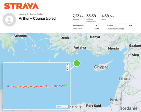
French aircraft carrier Charles de Gaulle tracked via Strava activity in OPSEC failure
As funny as that is, something tells me it’s not that hard to spot an aircraft carrier in the Mediterranean
You have to be visual range, or radar range of you have one, which is the horizon plus a bit more depending how high above sea level your are and how tall your target is.
If you’re on a ship, unless you’re using an advanced radar that bounces signals against the ionosphere your radar horizon is surprisingly short, something around 12 nautical miles give or take. And the sea is big and Iran is quite far.
This is one big reason why aircraft are used for surveillance at sea. They can go much higher than any ship’s radar antenna mast every could be which significantly increases their detection and identification ranges. They can also travel out to see when further.
Right now because if this, Iran now has the intel that the French carrier is approaching without even having to send an aircraft out to look for it. If they even ever have the ability to at this point.
So satellites can see my truck’s plate but an aircraft carrier and it’s escrow fleet are too… Small?
Sort of. Satellite resources are surprisingly scarce, so a lot are focused where people are, i.e. land. Plus, for the imagery sats that are focused on the ocean, ships are also tiny in a literal ocean of blue. It’s just a spec. While the resolution could be good, have fun looking for that spec. That’s why most countries use signal collection to locate vessels at sea. (I’m over-simplifying a lot, but you get the picture)
While the resolution could be good, have fun looking for that spec.
Seems like an easy but tedious job. Something that a computer can do.
Object detection algorithms are incredibly fast and can learn to tell the difference between an aircraft carrier and an ocean.
There are a surprising amount of false positives when using object detection on maritime imagery. While a carrier is a spec, there are a ton of specs in the ocean that can look similar enough. Plus, weather has a huge hand to play. If it were always perfectly clear, then it’s an easier problem, but one cloud can really mess up the detection. Ultimately, ship detection is a difficult problem (not intractable but still hard).
False positives are fine, you assign 1, 10, 50, 100 analysts to review hits. You only need to find it once, then the search area becomes incredibly small for each subsequent satellite pass.
I’m not saying that it is easy, just that you don’t need to have a surface ship within 15 nm in order to see it.
I’m not saying that it is easy
It kind of sounds like you’re saying that. Anyways, there’s a reason submarines exist
It is simple, it is not easy.
‘Take a picture of the entire ocean and look for ships’ is simple, but executing that plan is not.
It requires hundreds of millions of dollars of reconnaissance satellites, and an entire branch of personnel to operate and digest the information.
This is why the US operates carrier battle groups instead of just sailing their carriers everywhere with a small escort. They can’t hide, but they can pack enough offensive and defensive power into a tiny area to make most attacks infeasible.
Anyways, there’s a reason submarines exist
True, and even they’re vulnerable when they surface (if they’re moving), the v-shaped wake is also very detectable from space where satellites can detect wave heights within 3cm. It’s not easy for humans to find, but with billions of dollars to spend on computers, these kinds of things are very much within the reach of sovereign nations.

I agree with the premise of “simple but hard”. However, I still want to underscore that large areas of the ocean will at any given time be covered in clouds or fog. Sure, once you find the ship the first time, you’ve narrowed your search radius significantly, but a ship that can move at 30 knots can move around 1500 nautical miles (2800 km) without being seen under just 48 hours of cloud cover. That means any intel on the position of a ship carrying weapons that can easily strike at ranges of 500-1000 km is fresh produce. Just a day after you spotted that ship, it can have moved almost 1500 km, and if you lose track of it under clouds during your next satellite pass, it can suddenly be 3000 km from where you last spotted it.
What this means is that the “hard” element here is significant. Even the “simple” element becomes complicated by stuff like night time and cloud cover. All this taken into account, there are very few countries in the world with enough surveillance satellites and processing capacity to actually keep a pin on a ship at sea over any significant period of time.
You still need to know where to point that spy satellite’s camera at. If you take picture that covers hundreds of square kilometers then you don’t have enough resolution to spot the ship but you can’t zoom in much either because you don’t know where to zoom.
It’s different with buildings because you know where they are.
It depends a great deal on if you have access to a real-time satellite feed and know where to look.
China and Russia could also just tell Iran, if they don’t have satellites of their own
The Swedish Navy’s ships do have some bonkers designs, like massive barcodes printed on the side. It’s so that when they get back to port they can scan the navy in.