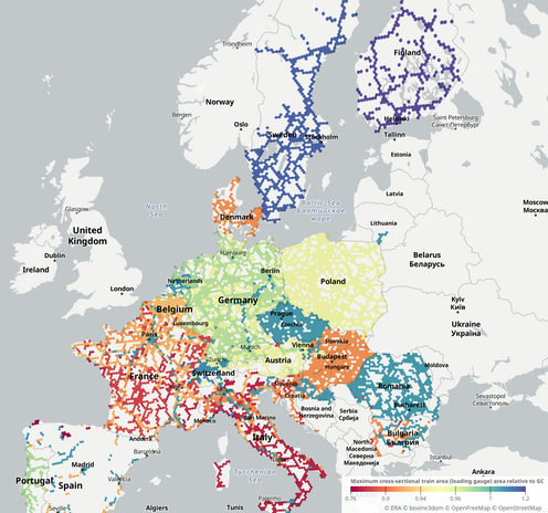
new map for you all: "how big can trains be?" across europe using declared loading gauges from the ERA RINF. purple = big trains, red = small trains, green = somewhere in between.

https://compute.olie.science/expo/?data=loading_gauge/2026-03-18#x=8.0973&y=48.8056&z=5.0605

thanks go to @kaat0 for helping with the data. all mistakes are my own :)

@bovine3dom Don’t show this to Swedish railnerds, they’re already arrogant enough about our large loading gauge :D

(And then we have like 25%-50% shorter platforms so I’m not even sure who we’re trying to fool.)

@kaat0

Dr. Sobek (@[email protected])

@[email protected] @[email protected] Though, ETCS + TGV M will increase passenger capacity for sure, kicking the can down the road a bit further. Is the 400m length a signalling constraint or only a platform length one ? Making longer trains would be another engineering solution to bypass the doubling of the line, and lengthening platforms can't be as expensive as doubling up lines ?

Mastodon -- Sciences.Re

@aslakr @cycling_on_rails @stefanlindbohm @kaat0 @Sobex

@jon you might find higher resolution platform height/length maps useful for your work, just don't expect to see anything until you zoom in. and afaict the swiss haven't bothered to populate the right fields with data

exact figures shown on tap/hover

https://compute.olie.science/expo/?data=platform_lengths_hires/2026-03-19#x=2.3484&y=48.8607&z=13.2751

https://compute.olie.science/expo/?data=platform_heights_hires/2026-03-19#x=8.7705&y=50.1193&z=11.9575

H3-MON: THE MOST POWERFUL MON(itor) IN THE UNIVERSE

@stefanlindbohm did you see these ones? they're a more extreme version of what you're asking for.

---

https://www.google.co.uk/maps/@58.1270606,26.3246072,3a,75y,126.4h,88.14t/data=!3m7!1e1!3m5!1sLD6f2LK6WyYffKkpXrdHiA!2e0!6shttps:%2F%2Fstreetviewpixels-pa.googleapis.com%2Fv1%2Fthumbnail%3Fcb_client%3Dmaps_sv.tactile%26w%3D900%26h%3D600%26pitch%3D1.8628420709444242%26panoid%3DLD6f2LK6WyYffKkpXrdHiA%26yaw%3D126.39559033165146!7i13312!8i6656?entry=ttu&g_ep=EgoyMDI2MDMxNS4wIKXMDSoASAFQAw%3D%3D

out of interest this is the smallest platform i can find without cheating, 58°07'36.1"N 26°19'31.4"E, Palupera. ERA claims 30m but measuring the satellite image it looks more like 20m. pretty cool design for the shelter.

Bevor Sie zu Google Maps weitergehen

@bovine3dom I did! I meant the other way around, i.e. larger hexes. Basically so that each city area gets a single hex rather than multiple scattered.

(I’m coming out of a bad cold with a very fuzzy head - saying things is still hard 😅 )