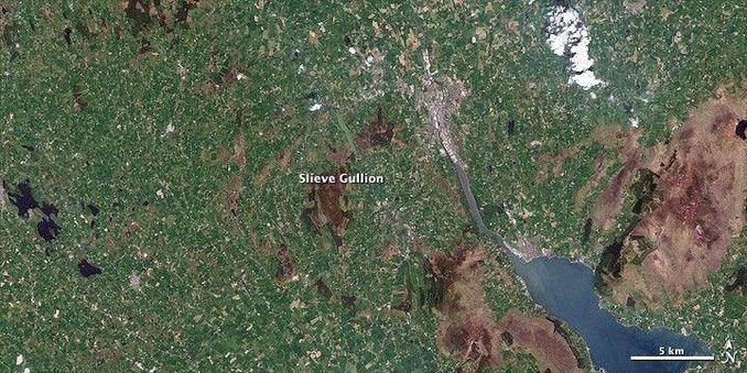
#PPOD: Covered in heath, the solitary rocky hill known as Slieve Gullion rises above the farmland of Northern Ireland in this true-color Landsat image from May 24, 2001. According to Irish mythology, hunter and warrior Finn McCool bathed in the lake on Slieve Gullion and emerged decades older. However, we don’t need a dip in the lake to move through time. A glance at the landscape reveals millions of years of history.

#science #earth

Looking out from the summit of Slieve Gullion, the mythical Finn McCool (or anyone else who climbed to the top, for that matter) would see a ring of rocky hills surrounding the Slieve. From a satellite view hundreds of kilometers above Earth, the formation's circular shape is even more evident. Known as the Ring of Gullion, the ancient hills are nearly 60 million years old.

They formed either when an ancient volcano collapsed—leaving a circular fault into which molten rock seeped—or when layers of magma built up in layers in the volcano. This type of formation is called a ring dyke.

Credit: Jesse Allen and Robert Simmon, using Landsat data provided by the United States Geological Survey; Caption: Holli Riebeek

Learn more: https://science.nasa.gov/earth/earth-observatory/ring-of-gullion-northern-ireland-46313/

Ring of Gullion, Northern Ireland

A rocky ring of hills in Northern Ireland rises from green farmland in this Landsat image, revealing the ancient geology of the island.

NASA Science