We just finished mapping all the buildings in Co. Down, and I wanted to write the usual blog post with all the statistics using ohsome.org, but it won't let me choose County Down as an area. Is there quick and easy way to get the bounding box from a geojson file for Co. Down? #OpenStreetMap #ohsome #heigit @heigit
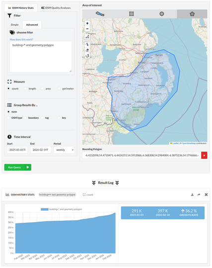
@BUnicycling in the ohsome dashboard, you can draw the outline of your area of interest also manually. For example: https://dashboard.ohsome.org/en/#backend=ohsomeApi&groupBy=none&time=2025-01-01T00%3A00%3A00Z%2F2026-02-19T11%3A00%3A00Z%2FP1W&measure=count&bpolys=-6.4232098%2C54.4710471%2C-6.4424255%2C54.3912086%2C-6.368308%2C54.2984009%2C-6.3875236%2C54.1796866%2C-6.2749748%2C54.0670748%2C-6.102034%2C54.0025877%2C-5.8604658%2C54.0509624%2C-5.629878%2C54.2005666%2C-5.4047804%2C54.351231%2C-5.363604%2C54.5220622%2C-5.4459567%2C54.6588499%2C-5.602427%2C54.7080445%2C-5.8604658%2C54.6715509%2C-5.9785048%2C54.5714223%2C-6.1130143%2C54.4806173%2C-6.4232098%2C54.4710471&filter=building%3D*+and+geometry%3Apolygon
@heigit I know, but it's a whole county, that'll take forever.
@heigit 25mins roughly.
@BUnicycling we are still investigating the issue about the missing county boundary data, which seems to be specific to Northern Ireland. It might be because the boundary has changed back and forth, so we don't have it in our boundaries table. While we are working to resolve the issue for future analysis, we're happy to hear that the manual drawing worked for you, even if it took so long. Thanks for the update!
@heigit I'm fairly sure it's because the tag was changed from boundary=administrative to boundary=historic. Would you be able to use it, if it was historic:boundary=administrative?
@BUnicycling it seems that the issue is known and needs to be solved in OSM: https://wiki.openstreetmap.org/wiki/Northern_Ireland#Administration_Areas