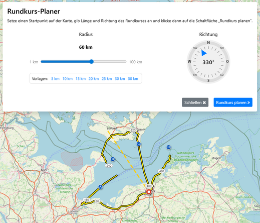
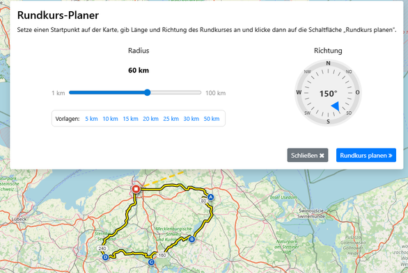
I’ve been spending a lot of time at the keyboard lately, and I’m excited to announce that a round‑trip planner is rolling out to #Bikerouter in the next few days.

This feature is powered by the round‑trip routing introduced in #BRouter 1.7.8. Choose a starting point, set a maximum distance (the loop’s radius), and pick an initial heading. The planner will then generate a round-trip using the currently selected routing profile.

It’s available now for testing at https://dev.bikerouter.de

bikerouter.de

▶ Der wahrscheinlich beste Fahrrad-Routenplaner der Welt! Kostenlos und datenschutzfreundlich. Gravel, Rennrad, MTB, City, Long Distance, Trekking uvm.

Marcus Jaschen
Roundtrip Planner - Bikerouter Documentation

None

@bikerouter Super, vielen Dank!! 👍
Tipp: Vielleicht könntest Du die "estimated route length" aus den Docs direkt im Rundkursplaner mit unter die Einstellung für den Radius setzen (evtl. mit Erklärung)? Der Rest ist ja sonst ziemlich selbsterklärend.

@bikerouter

Well, this didn't go to well 😯

I suppose the feature ignores water?

@bikerouter

It kind of works in the other direction but the total distance is way off.

Roundtrip Planner - Bikerouter Documentation

None

@bikerouter Thanks. I just noticed, that one chooses the radius. This contradicts the instruction above. That's where I stopped reading.

From my point of view adding the choice of max distance would be useful. mapy.cz has this.

Mapy.com

Popular map portal covering whole world by wide range of maps - basic, outdoor (hiking/cycling), traffic, winter. It offers possibility of aerial and 3D view. Extensive amount of travel points of interest. Users are able to search places, plan routes, measure ground and create and share own content. Tourists worldwide use map portal for detailed hiking and cycling maps and extensive tourist guides.

Mapy.com
@Einzigartiger Thanks for giving it a try! If the initial heading points out to sea, the planner won’t produce a useful route. Since bicycle round trips over open water aren’t supported, choosing a heading over land will work much better.
@bikerouter Für mich plant das leider bisweilen keine "richtigen" Rundkurse, sondern solche Gebilde mit diversen Sackgassen. Kann ich das irgendwie beeinflussen? Klar, ich kann und werde die Route manuell bearbeiten, aber nur als Hinweis.

@mattsches @bikerouter

Sosehr ich den Bikerouter liebe, das mit den Sackgassen geht mir genau so. Auch sind bei Sackgassen manchmal ungeeignete Wegoberflächen dabei (Profil Rennrad).😕

@antour @bikerouter Das Profil von Rennrad auf Gravel zu ändern hat bei mir ziemlich viel gebracht - fahre aber auch hauptsächlich Gravel. Da kenne ich (fast) keine Sackgassen 😅
@bikerouter top feature! wunschdistanz in km statt radius wäre allerdings schon sehr viel intuitiver (wie schon angemerkt wurde), auch wenns nur grob matcht. am radius zuppeln und schauen dass die ungefähre tracklänge (die drunter in grau steht) passt ist n bisschen unintuitiv
@bikerouter andererseits verstehe ich natürlich dass es vorteilhaft ist, einen Slider mit nur 1-100 zu haben, während der dann eine Distanz von 5 bis ca. 650 km abdeckt. Sobald man das Konzept einmal verstanden hat ist es nicht mehr schlimm, eher für Erstnutzer halt größeres Verwirrungspotential
@bikerouter Coole Idee! Die Sackgassen erscheinen mir auch noch nicht ideal.
@bikerouter Danke - tolles Tool u, unterwegs effizient eine Route zu planen.