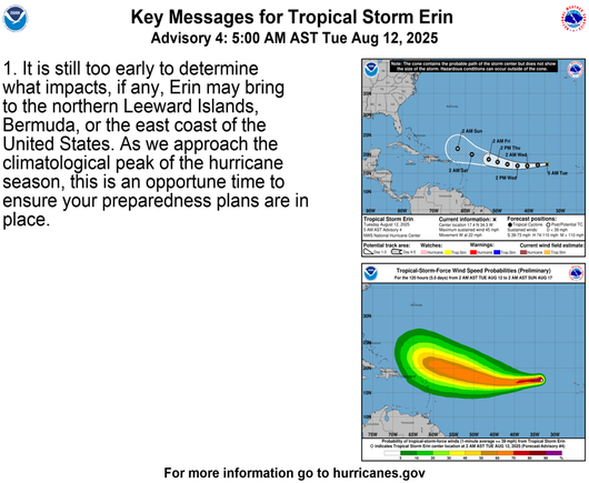
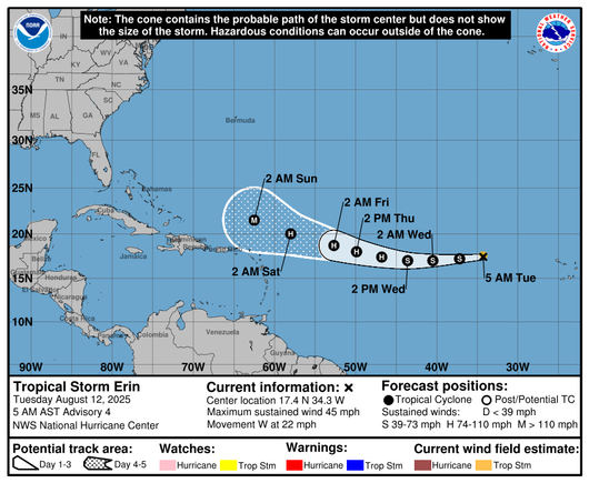
#TropicalStormErin is slatted to continue moving Westwards, approaching N of the Antilles and NW of Puerto Rico, around early morning Saturday.

By Wednesday early morning, it will be a full fledged Tropical Cyclone (aka hurricane), By Friday late evening/early Sat morning, it will be a Major Hurricane (winds greater than 110mph, ~Cat3)

#Erin #Weather #Caribbean #Atlantic

MOST LIKELY (stomps foot three times) this storm will NOT approach Florida. And MOST LIKELY, there won't be significant damage to Antilles or PR. BUT, keep an eye. The track record of storms has been affected by a vertiginously changing climate, which significantly amplifies weather extremes.

#TropicalStormErin #weather #Caribbean #Atlantic

Things I do NOT like.

https://www.star.nesdis.noaa.gov/GOES/sector_band.php?sat=G16&sector=taw&band=GEOCOLOR&length=24

See the patterns over Cuba, from Venezuela. Veering NNE to N, then NNW.

Erin is headed for a clash with the remainders of that. The remainders of that will be mostly WIND, pushing Erin N.

System now approaching Yucatan will be dispersing NNE, when Erin NW off of PR. Erin movement is steadily W, now, and tending to become WNW. 50+% of push N.

Inshallah I am wrong.

#Erin #weather #Caribbean #PuertoRico #Atlantic

GOES-19 - Sector view: Tropical Atlantic - GeoColor - NOAA / NESDIS / STAR

Near real-time publication of GOES-East and GOES-West images from NOAA/NESDIS/STAR

GOES Image Viewer - NOAA/NESDIS/STAR website