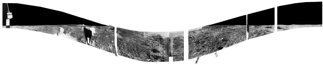
I am going to examine the panorama in detail later, but here is a quick look at it at reduced resolution. It has been roughly projected to make the horizon level - the scanning camera axis was tilted down towards the east and up towards the west. We can see about 65% of the horizon from south to west to north. In this view east is in the middle, west at the ends. The horizon is flat. #moon #Luna9
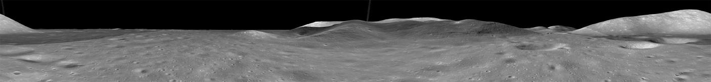
The usual quoted coordinates are in a valley between prominent hills. We can reconstruct a panorama from that location using LRO images and topography. Here is the result. Again, east is in the middle. Sharp brightness changes are from the original LRO mosaic. The largest hill, due west of the supposed landing site, would be very prominent. The lander can not be at that location. #moon #Luna9
Let's look at the panorama transmitted by Luna 9, the first view we ever had on the lunar surface. Actually it's 3 panoramas, taken over 2 earth days, with the lander shifting a bit between them, possibly slipping on a slope. See them here:
http://mentallandscape.com/C_CatalogMoon.htm
(Don MItchell again) - look about 20% of the way down the page.
Here is a translation of a Soviet paper on the pictures:
https://ntrs.nasa.gov/api/citations/19670002910/downloads/19670002910.pdf
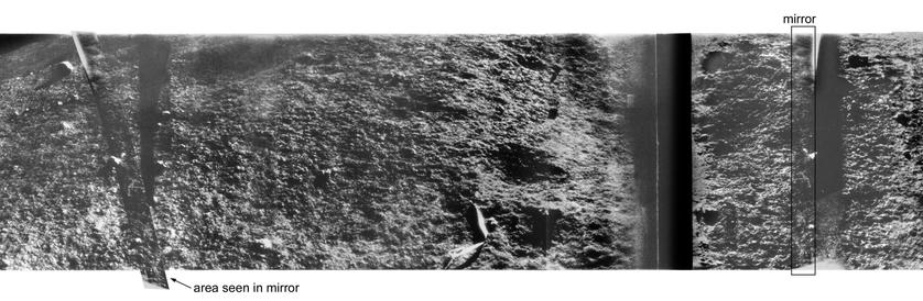
Here, taken from Don Mitchell's site, is panorama 1. There is plenty to say about it. At left is a hanging photometric target. In the middle a big section is washed out by glare - the Sun is only just above the horizon and outside the frame. Panorama 3 fills it in for us - the Sun is higher in the sky. We can see some vertical structures, which we can see better in an enlargement (next post). #moon #Luna9

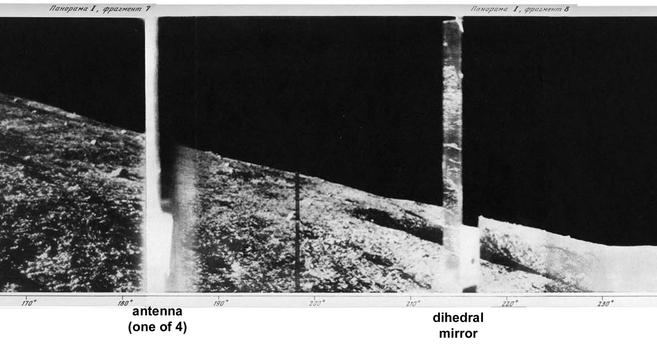
Here is a section from the right side of the panorama. At left is an antenna - pictures of the lander show it had 4 of these. At right is a dihedral mirror - a two-sided mirror. Each of its sides reflects a narrow strip of the surface, and if we search for the area viewed in the mirror we can see a bit of the surface from 2 directions and get some topographic information. There were 3 of these. #moon #Luna9
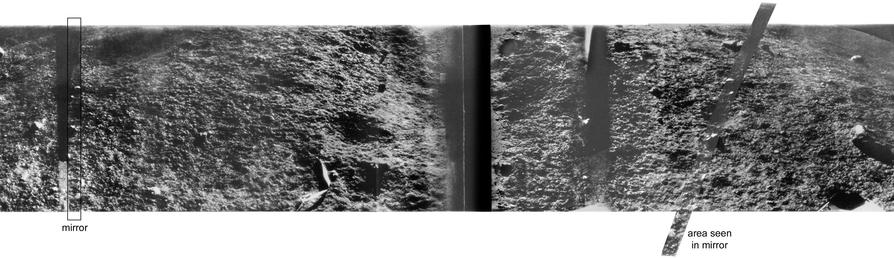
Here is part of Luna 9 panorama 3 from the site I linked to. It's the middle section, showing how the part that was not seen properly in panorama 1 is seen clearly here. At left I point out one of the mirrors (one half of the dihedral mirror). If you didn't know it was a reflection it would look the same as the surrounding surface. At right is the area it is reflecting (the mirror section copied, pasted, flipped and registered with the base). Fun with Photoshop. #moon #Luna9
Here is another example of the same thing from Luna 9 panorama 3. I don't know how useful this was, and it was not attempted again, but it makes for an interesting exercise in image manipulation. #moon #Luna9
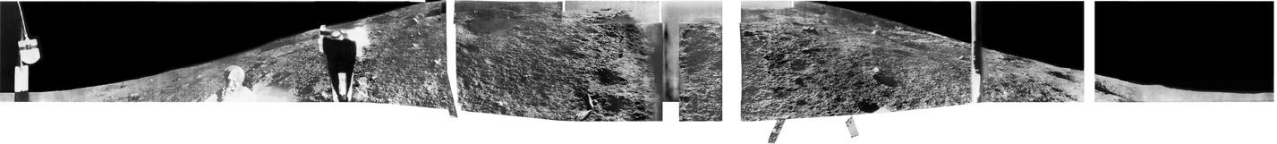
Luna 9 took 3 panoramas, shown on the earlier link. They can be combined to make the image shown here. Panorama 1 (the only one with the horizon at each end) is the base. Bad bits in it have been replaced with better bits from the other panoramas. The lander tilted down between panoramas, either from settling in loose soil on a slope or from thermal expansion of its fold-out 'petals'. I cut out the mirrors since they block the scene behind, and added 3 sections seen in the mirrors. #moon #Luna9
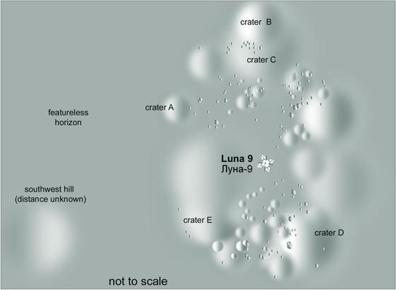
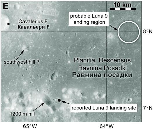
Time to consider where Luna 9 is. My first map for Luna 9 shows the location of the NSSDCA coordinates, which come from Soviet estimates: 7.08 N, 64.37 W. From my map you might think it looks more like 64.7 west - that shift is caused by better map control today. In 1966 those coordinates would put you in that gap between hills. My map uses modern coordinates but I have moved my point to be in the right place in the landscape. You can't just assume 1960s coordinates are reliable. #moon #Luna9
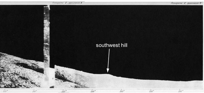
I already pointed out Luna 9 can't be between those hills because they would be visible on the horizon. For years I have argued that Luna 9 has to be further north, as my map suggested, so the hills are over the horizon. A small hill is visible on the southwest - as shown here. I though it might be visible on a map to give another clue. But is it nearby and small or distant and big? There's no way to tell. I show the hill and a suggested location in that earlier map. #moon #Luna9
I never really tested that assumption. Recently I have revisited the issue with a new tool, the Quickmap synthetic panorama tool. I can make a panorama for any location. Surprise - you have to go quite far north to lose those hills and then there is no good candidate for 'southwest hill'. This is from 30 km north of the map site. But I noticed that the largest hill in that range starts to look the the SW hill if you get far enough away and the other hills are below the horizon. #moon #Luna9
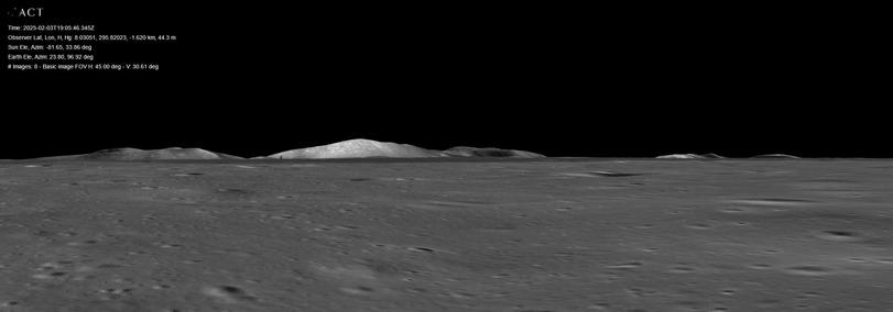
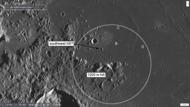
This map shows the Luna 9 area (from Quickmap again). A is the usual site. B was my older estimate, putting a hill in the right place to be SW hill. C is far enough north to lose the big hills but then where is SW hill? But over at D, still inside the Soviet 50 km radius circle, the 1200 m hill could actually be the SW hill - all its neighbours are now below the horizon.
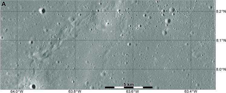
Is this correct? We can't prove it unless we can find Luna 9 in LRO images. We will consider that tomorrow. #moon #Luna9
Want to find Luna 9? You are not alone, but many people have looked for it without success. All the points I have made about uncertainty in the location help to explain why. We don't know where to look. But feel free to scroll through hundreds of full LRO Narrow Angle Camera images (each one 5000 by 50000 pixels) looking for something very small.
What are we looking for? This link goes to a mission description with an image of the landing process:
(Russianspaceweb is a fantastic resource). The lander is 30 cm across (bigger with its petals) but it's barely resolved and will look like a rock. But there's more to look for. We start with the main spacecraft reaching the ground and shutting down its thrusters (far right). It ejects its landing capsule, encased in a protective 2-lobe airbag. The airbag splits and falls aside, the lander rolls to a stop and opens its petals, thereby righting itself. #moon #Luna9
Here is a view of what it might look like. This is Luna 23 with some fictitious added details. The decent thrusters brighten the surface (we see this at most sites) so we can look for that and the main spacecraft itself. It dropped 2 equipment pods earlier but probably not close by. Then we might see the airbag sections and the lander itself. The lander will just look like a rock but the ensemble will be the evidence we need. But there's more to look for as well...
#moon #Luna9
#moon #Luna9
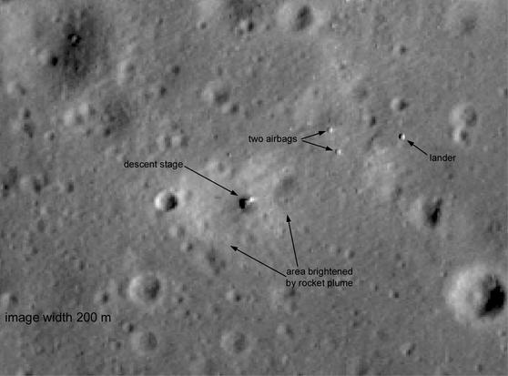
Because Luna 9 took pictures we have maps of the surroundings. So we can look for the pattern of craters around Luna 9 as well as the hardware. Between the two we should get a solid identification... IF we can find it.
Let's look at maps of the site. The Soviet publication 'First panoramas of the lunar surface' (Moscow: Akademiya Nauk, 1966) included maps drawn from the images. My map here is a shaded relief version of their drawn maps. #moon #Luna9
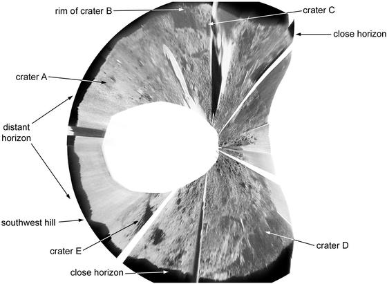
That sounds easy ... but the map is only an interpretation of rather small low angle images. Rolling terrain, lack of stereo at a distance and low resolution make mapping difficult, especially the more distant features. How far away is the northern horizon? We can't really tell. Here is a version of the panorama projected into a circle (my party trick) - it's not easy to relate the previous map to this image. If we find this place in LRO images we should be able to match features. #moon #Luna9
To complicate matters further, here is a map drawn basically just using the projected panorama. It doesn''t match the earlier map very well so which should we use?
These are difficult problems but one day a human being will solve them. Are there other approaches? Hyperspectral or radar imaging capable of detecting metal fragments? Maybe, but not at resolutions available to us today.
That's enough about Luna 9. Time to move on to some orbiters. #moon #Luna9
Luna 9 was followed by the orbiters Luna 10, Luna 11 and Luna 12. Luna 10 was the first spacecraft to orbit any body beyond Earth. Luna 11 was intended to take pictures of the surface (again on a film camera) but it failed (its orientation could not be controlled). The descriptions of the missions at NSSDCA fill in the details:
Luna 10:
https://nssdc.gsfc.nasa.gov/nmc/spacecraft/display.action?id=1966-027A
Luna 11:
https://nssdc.gsfc.nasa.gov/nmc/spacecraft/display.action?id=1966-078A
They returned data on radiation, lunar gravity and composition. Tomorrow: Luna 12. #moon #Luna10
I didn't go into much detail with Lunas 10 and 11 because my main interest is in missions which produce images or whose locations or rresults can be mapped. Luna 12 allows both. The basic details of the mission are given here:
https://nssdc.gsfc.nasa.gov/nmc/spacecraft/display.action?id=1966-094A
It says only 2 images were released but we actually have 4:
http://mentallandscape.com/C_CatalogMoon.htm
Here are the images and a map of the area in which they were taken (from a Soviet popular space book whose details I have lost). #moon #Luna12
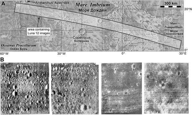
About 40 images were taken, but this is all we have. I should point out that the Soviet Union never undertook systematic mapping of any world except Venus (Venera 15 and 16 radar mappers).
Each image is about 5 km across and the resolution is 5 m/pixel. This is just about adequate to plan human landing missions, but many more images would be needed, and closer to the equator. The Soviets never took the pictures needed for human landings, and yet they did select landing sites. #moon #luna12
The two images at left are said to be near Aristarchus (27 October) and the two at right are in Mare Imbrium (29 October, despite the NSSDCA details about pictures). The exact locations have not been found.
So how were cosmonaut landing sites chosen? I will look at it later, but let's say they had to be using NASA's Lunar Orbiter images, or conceivably the maps and photomosaics prepared from them by the US Army and Air Force, but we don't know the details.
#moon #Luna12
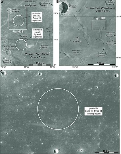
Moving on to Luna 13, again we don't have an exact location. Map A shows the region with the Luna 9 and 13 probable target areas (ray-free maria). Map B closes in on the landing site and Map C is a closer view. I must emphasize I have never seen an estimate of uncertainty and the stated coordinates (NSSDCA: 18.87 N, 62.05 W) are far too precise (they are just the centre of the landing area). The landing could be anywhere in Map C, and my circle is not an error ellipse. #maps #Moon #Luna13
Back to Luna 13, here is the NSSDCA page about the mission:
https://nssdc.gsfc.nasa.gov/nmc/spacecraft/display.action?id=1966-116A
The picture shows a spacecraft similar to Luna 9, except it has 2 cameras on top instead of 1 and two folding arms which deployed instruments to the surface to measure its hardness and density.
Here, on Don Mitchell's site:
http://mentallandscape.com/C_CatalogMoon.htm
about 1/4 of the way down the page, are the 5 panoramas taken by one of the cameras. The other didn't work.
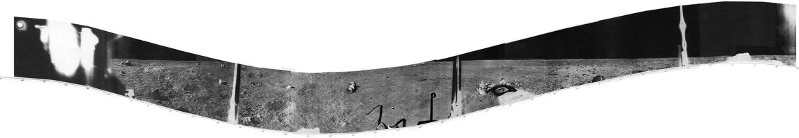
The first panorama is only a fragment but the others are more complete. They can be joined to create a full panorama, and you will see the spacecraft shadow changing as the Sun gets higher in the sky. Someone could animate that. There are a few fragments of hardware, presumably from the fallen descent stage - the lander popped off it as it touched down and rolled some distance away. Tomorrow, my version of the full panorama. #moon #Luna13
Here is the full Luna 13 panorama, made by joining sections of the 5 panoramas to fill gaps. No dihedral mirrors this time, but the 4 antennae are the same as Luna 9, except that we only see 3. One is hidden by a fuzzy blob at the left edge. There were 2 cameras and the blob is the second camera seen very close up by the first. The second camera didn't work. The middle of the view faces a bit south of west. #moon #Luna13

And here is a version with the horizon rectified. It's almost flat, exactly as we would expect for a site far from any large hills or crater rims. The shadows of lander antennae are seen near the middle and one of the arms with a densitometer (measuring the density of the regolith) is to its right. #moon #Luna13
I'm going to step back in time slightly to look at the Luna 9 location again, then do the same for Luna 13. I'm working on the Luna 9 problem at the same time I'm posting this sequence. I said we don't know how far away the 'southwest hill' is, but still talked about possibly seeing it in the panorama. I now prefer to discount it (i.e. it's a small local mound, not a distant mountain). It looks like you have to go too far north to avoid seeing the 1200 m hill and other mountains.
#moon #Luna9
#moon #Luna9
The Luna 9 panorama does have a bit of local relief on the horizon, especially to the north (see the circular projection of the panorama, though note its horizon relief is exaggerated in that view). I'm moving my preferred location east, just east of a wrinkle ridge in the plains. That ridge will give us a bit of irregularity on the horizon, and might just raise the level of the local horizon enough to hide the distant hills. Here's my new guess. #moon #Luna9
That puts the landing somewhere in this map. Obviously we can't prove anything here, and I hope this illustrates just how hard it is to figure out where to look for the lander in LRO images.
OK, now we will come back to Luna 13 and see what constraints there are to its location. It's not many! There is a great discovery waiting for someone in images which are already on the ground.
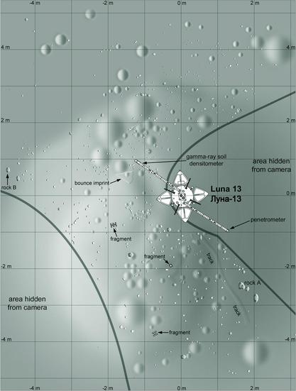
Back to Luna 13, and it's time to consider how we might find it. The pattern of artifacts will be similar to what I showed for Luna 9, a schematic image showing a bright patch around the descent stage, the lander only about 1 pixel across, and maybe the two airbag fragments. Also we can look for the pattern of surface features seen in the panorama. Here is a map of the landing site, a shaded relief rendition of a drawn map in the soviet source (ref in next post). #moon #Luna13
The source of the map is:
Academy of Sciences of the USSR, 1969. First panoramas of the lunar surface, Volume 2. Moscow: Akademiya Nauk.
It's not always easy to locate these features in the panorama reliably. Looking at the pictures, I feel that the big 'rock A' feature might be bigger and further from the lander than this suggests. The lander would be only 1 or 2 LRO NAC pixels across and almost everything in this map is smaller. What lies further away, towards the horizon? #moon #Luna13
This is a version of the Luna 13 panorama projected to make it easier to compare with an orbital image. The most significant feature is the 'northern crater' which is far enough away that it and he small craters inside it would be big enough to see in orbital images. I think that offers the best chance of finding Luna 13. We should see that crater and the pattern of features expected for the lander and its other hardware. I have looked, but no luck yet. #moon #Luna13
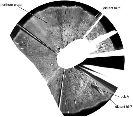
This is a rough sketch map showing those distant features. It's hard to be sure of the size of that crater. There is a hint of similar features to the southeast in the projected panorama but I did not try to map them. I think Luna 13 should be easier to find than Luna 9 based on this approach. I have idly speculated that 'rock A' might even be the fallen descent stage, but that is probably not true. #moon #Luna13
After Luna 13 we have to wait a while for another surface mission. I won't go into much detail where we don't get pictures. Kosmos 159 was supposedly similar to Luna 12 but was operated only in a highly elliptical Earth orbit. It's not clear if it was intended to go to the Moon. Luna 14 did orbit the Moon, testing communications and measuring radiation, gravity and lunar surface radar reflectivity. #moon #Luna14
Now we move to a new class of lunar spacecraft, Zond. But this is nothing like Zond 3, the old Mars probe which was repurposed to image the far side of the Moon. These Zonds were what later became Soyuz spacecraft, initially designed to carry people to the Moon and later to Soviet space stations. And the timing is significant - this is the second half of 1968, with Apollo ramping up and not much time for a Soviet mission to leap ahead. Tomorrow we will get to grips with the Zonds. #moon #Zond
The purpose of the spacecraft series we call Zond 4 to Zond 8 was to perfect a very complex trajectory and re-entry before humans were entrusted to them. Later they became the Soyuz spacecraft still used for space station crews. I don't know what they would have been called if they took people to the Moon. The first was called Zond 4, early in 1968. It was sent to lunar distance but 180 degrees from the Moon so lunar gravity would not complicate its orbit. On return... #moon #Zond
... on return Zond 4's guidance system failed and it hit the atmosphere without performing its 'skip' out of the atmosphere and back in at lower velocity. The spacecraft was destroyed over the Atlantic Ocean near Africa so it would not be recovered by the US.
Next, in September 1968, was Zond 5. This flew around the Moon and back to Earth with a biological payload (turtles and various invertebrates, plants etc. But again its return was compromised. #moon #Zond
Zond 5 lost attitude sensors, could not land in the Soviet Union but fell into the Indian Ocean where it was recovered. Cosmonauts might not have survived the re-entry. Images of Earth were taken but not the Moon (at least none were released).
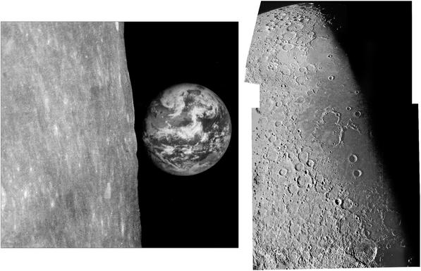
Zond 6 flew a better trajectory and this time brought back images of the Moon. The landing was again spoiled (parachutes ejected at high altitude). This and other problems would have killed a crew. This was only a few weeks before Apollo 8. #moon #Zond
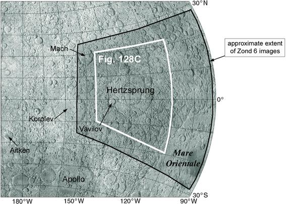
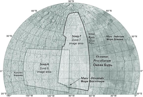
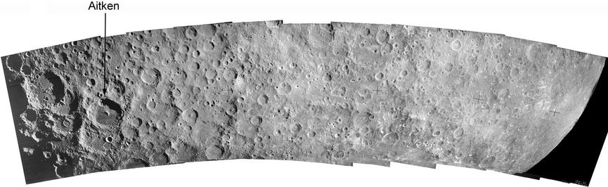
Zond 6 images taken on film were nearly lost when the spacecraft crashed in Soviet territory. The film container was split and light spoiled some pictures, but enough were intact that some scenes could be recovered. Here (from material I scanned in Moscow) are views of a full-phase disk centred north of Orientale, A limb view with Earth, a mosaic of frames covring part of the farside, and a close-up of Vavilov crater. #moon #Zond
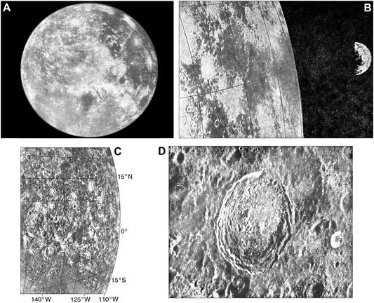
This map is based on a Zond 6 image index map I scanned at MIIGAiK. The region covered here was mostly seen by Lunar Orbiter obliquely near the terminator, and the Vavilov image shows some Zond 6 coverage was the best available at the time. The most significant science was from the full disk view. Careful measurement of the limb at lower left revealed a huge depressed area - the South Pole-Aitken basin (ref in ALT text). #moon #Zond
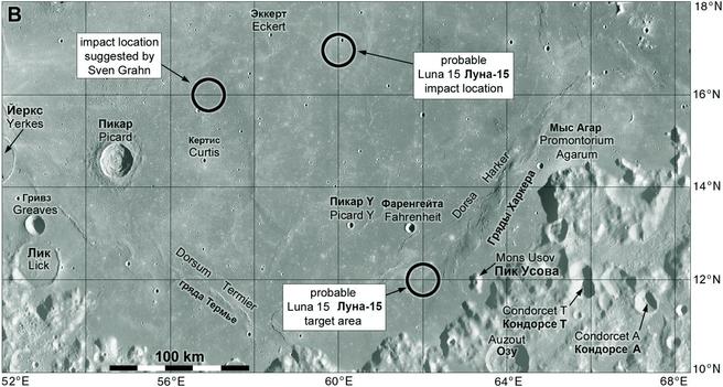
Next up after Zond 6 was Luna 15, a sample return lander which flew at the same time as Apollo 11. This was a last-ditch effort to bring a sample back before Apollo, allowing the Soviet Union some small bragging rights. If Luna 15 had followed the flight profile of Luna 16 it might have returned lunar samples slightly ahead of Apollo 11, but it spent an extra day in lunar orbit and lost that chance. Then it crashed the day after Apollo 11 landed - but where? #moon #Zond
This map shows some sites. NSSDCA says 'the spacecraft impacted the lunar surface on July 21, 1969 ... at an estimated position of 17 N, 60 E. Other references give the crash site as 12 N, 59 E or 17 N, 49 E.' It's our old familiar story - we have not one possible site but several (there are other suggestions too). What's a poor cartographer to do? I hope that one day we will have better documentation for this from dusty file boxes in the Lenin Library. #moon #Luna15
The next Soviet mission would be Zond 7, but also around this time in 1968 people were working on landing site selection for Soviet cosmonauts. The chance to be first was gone, but while a landing was still being considered sites were needed. I said earlier that Soviet missions never undertook systematic mapping or took images good enough for site planning with the dubious exception of Luna 12 (just barely adequate but very few images and too far north). #moon
It follow that any serious work was done using NASA images - Lunar Orbiter images - and therefore sites were limited to Lunar Orbiter targets used for Apollo planning. 3 equatorial regions in the western, central and eastern maria were studied, just as for Apollo. These were in Oceanus Procellarum, Sinus Medii and Mare Tranquillitatis. Basilevsky told me that Sinus Medii was rejected (too rough) leaving just the eastern and western areas in consideration. #moon
Basilevsky spoke at the Brown-Vernadsky Microsymposium in The Woodlands, Texas on 16 March 2014. He showed 4 sites corresponding to sites IIP-6, IIP-8, IIP-11 and IIP-13 as the potential landing areas. In 2016, 2017 and 2018 he taught a short course in Planetary Geology at the Macau University of Science and Technology, and a presentation from that class showed these sites labelled alpha, beta, gamma and delta (from west to east). Gamma was rejected. #moon
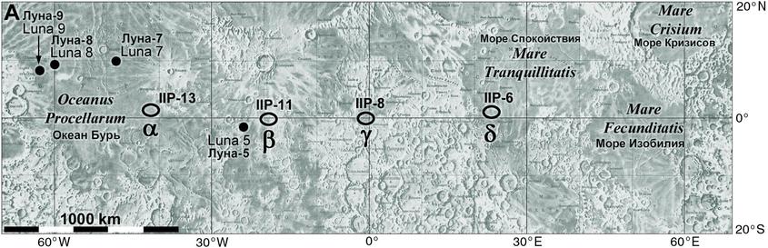
The one thing we don't know is if specific points or ellipses in those rather large Lunar Orbiter 'sites' were chosen. The word 'site' can be misleading. Delta is the Apollo site IIP-6 or Apollo site 2, used for Apollo 11, but any Soviet landing would not be in the specific Apollo 11 ellipse.
How did the Soviets get the images? We don't know. I've seen Jim Head teasing Basilevsky about it at a conference but Sasha couldn't say.
Zond 7 was the next test flight of the spacecraft intended to fly people to the Moon. It was a very successful flight and the only one which would have landed a crew safely, if it had a crew. But it didn't - it flew some turtles and a radiation sensor package, and it took pictures of Earth and the Moon. Here are two images from the mission, Earth over the limb (Earth is setting, not rising) and a mosaic of image running down the terminator showing Oceanus Procellarum at right. #moon #Zond
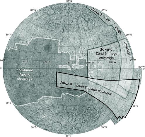
This map shows the extent of Zond 7 image coverage, extending a bit further south than my mosaic. This is from an index I scanned in Moscow.
NOTE: in my original posts for Zond 7 I accidentally called it Zond 6, which we have already covered. Posts have been corrected. #moon #Zond
Luna 15 was supposed to collect lunar regolith and return it to Earth, but it crashed. The next attempt succeeded. This was Luna 16, coming in the gap between Apollos 13 and 14. The Luna sample return missions had an ingenious method of returning to Earth. To escape the Moon they had to leave it at greater than lunar escape velocity. If they do that going forwards along the Moon's orbit they are going faster than the Moon and will fly out away from Earth... #moon #luna16
... but if they do it going backwards relative to the Moon's orbital motion, as they depart they are now orbiting Earth slower than the Moon, so they fall in towards Earth. By controlling the velocity and direction they can simply fall to Earth, timing it so they land in Soviet territory.
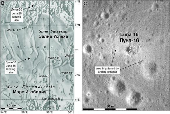
The price they paid for this convenience was a very restricted area from which to launch. All Soviet sampling missions went to a small area. This map shows the region. #moon #Luna16
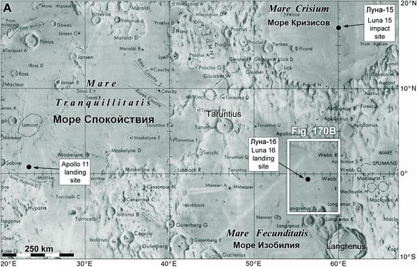
That very restricted area was a band roughly connecting the Luna 15 and 16 sites on that map. We'll be seeing several missions go to this area. Given such a restriction, the Soviet goal was to sample Mare Crisium, Mare Fecunditatis and the strip of rugged highlands between them. Two different lava flow areas and the highlands, a good suite of samples. We'll look a bit more closely at Luna 16 tomorrow.
Here is a picture of Luna 16 from Wikimedia:
https://upload.wikimedia.org/wikipedia/commons/b/bb/Luna_16.jpg
My image is part of that picture, annotated. Note the two cameras.
NSSDCA describes the mission:
https://nssdc.gsfc.nasa.gov/nmc/spacecraft/display.action?id=1970-072A
They say: "... strong and good quality television pictures were returned by the spacecraft. However, such pictures were not made available to the U.S. by any sources ..."
The pictures were also never published in the various publications on the mission. What's going on? #moon #Luna16
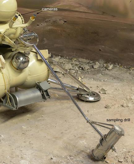
Each camera took a half-panorama from the horizon to the sampling area, so the sampling area was seen twice for stereo mapping. If a rock was in the way I think the arm could move a little to the left or right to avoid the obstacle. Why did we not see the pictures? NSSDCA points out they landed 60 hours after sunset, so not much to see! But they were taken and transmitted anyway, probably just to test the system. But what about Earthshine? #moon #Luna16
Not much was said about this at the time, but more recently we have learned that the pictures did in fact reveal some details. Apparently, bright glints off rocks could be seen faintly, but the image quality was too poor for them to be useful. That's too bad. I think that if we could get the original data off the big data tapes (which would almost certainly be in the Lenin Library), modern image processing could probably salvage something from them. #moon #Luna16
But why land in the dark? I note that they spent 3 days in lunar orbit before landing, so they arrived in orbit before sunset. Maybe there was just not enough time to check everything before sunset and be ready to land. Tracking during those 3 days helped improve knowledge of mascons, the gravity anomalies which complicate low orbit operations. But we don't really know why this happened the way it did. I close with another site map and a closeup LRO image composite. #moon #Luna16
Luna 16 was followed by Zond 8, the last test flight of this type of spacecraft. It followed the pattern of a flight around the Moon and back, not going into orbit (like Artemis 2, not Apollo 8 and 10). NSSDCA provides a few details:
https://nssdc.gsfc.nasa.gov/nmc/spacecraft/display.action?id=1970-088A
The photography was much better on this mission with large images taken of a full disk and a lower altitude strip of the farside highlands. Don Mitchell has a good selection:
http://mentallandscape.com/C_CatalogMoon.htm (halfway down). #moon #zond
Kira Shingareva came to Houston one year with CD-ROMs of scanned Zond 8 images. A set went to LPI, I got a set, there may have been others (I was her driver and guide on that trip). The scans revealed something interesting: the images were good quality but had a few scratches. They had not been protected as well as Apollo negatives were (after being developed they were copied and the originals archived for decades with all work done on copies). Only recently were they scanned again.
#moon #zond
#moon #zond
This map shows the Zond 8 image strip coverage, the Zond 6 and 7 image areas, and the Apollo image coverage (omitting only Apollo 13 and the global views taken during departure). Soviet planetary geologists made a nice set of maps of the Zond 8 area with relief drawings and a geological interpretation. Until LRO these were the best images of that region. A limb profile gave another look at topography in the South Pole-Aitken basin (see Zond 6 notes). #moon #zond
@PhilStooke Hello,
I found very intriguing photo at the site of Lavochkin Association at the section of Luna 16:
https://www.laspace.ru/upload/iblock/b2b/ityz3vlowmnfhzfr36fnzs20y9k7izr7.jpg
It seems like a small fragment of lunar horizon and some lander hardware. Is it possible that this image is from Luna 16? Other surface images in the section of Luna 16 are obviously form Luna 20. Here is this section of the website:
https://www.laspace.ru/en/activities/projects/luna-16/
Is it ever possible that there is Earth visible in this photo?
Regards,
Kamil Rzeszowski
@Kamil_Rzeszowski Kamil, this is a very interesting image, and one I have never seen before. The small section of the landscape at the right end of the image looks to me like it is too well lit to be he Lunma 16 site in the lunar night. There have been reports of a Lunokhod 2 image taken late on lunar day 2 with a crescent Earth in the sky, and I think that is the most likely source. Lunokhods had several cameras and one set could look up at the end of a panorama. That is my guess.