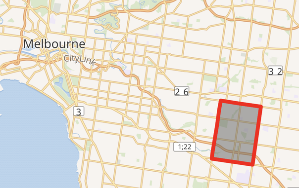
Today's #GeoWeirdness subject is the Melbourne suburb of Mount Waverley. Founded on the lands of the Wurundjeri people, Mount Waverley 3149 is Australia's most rectilinear postcode, almost exactly a perfect 2-mile by 3-mile rectangle, thanks to the Mile Grid. (1/12) #PirateGeoWeirdness #MountWaverley
The Mile Grid, designed by Robert Hoddle in 1837, is ubiquitous in Melbourne's southeast suburbs. Its tilt of 8° east of north crystallizes the direction of magnetic north around 1900. (2/12) #PirateGeoWeirdness #MountWaverley
The Mile Grid is different to the well-known Hoddle Grid of the Central Business District, which runs 20° west of north, to align with the Yarra River. (3/12) #PirateGeoWeirdness #MountWaverley
Both grids are visible in Geoff Boeing's 2018 survey of street directions of world cities. https://geoffboeing.com/2018/07/city-street-orientations-world/ (4/12) #PirateGeoWeirdness #MountWaverley
City Street Orientations around the World – Geoff Boeing

Named for the Waverley series of historical novels by Sir Walter Scott, the sprawling area was split into Mount Waverley and adjacent Glen Waverley in 1905. "Mount" Waverley is a gentle hill that not even I work up a sweat climbing. The suburb's highest point is about 140 m above sea level. (5/12) #PirateGeoWeirdness #MountWaverley

@futzle Oh hey, that's a danish-scale mountain! Almost as high as Sky Mountain in Denmark.

https://en.wikipedia.org/wiki/Himmelbjerget

Himmelbjerget - Wikipedia