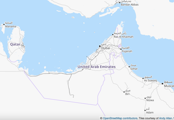
The US ๐Ÿ‡บ๐Ÿ‡ธ / Israel ๐Ÿ‡ฎ๐Ÿ‡ฑ/ Iran ๐Ÿ‡ฎ๐Ÿ‡ท war has put the world's focus on the Strait of Hormuz.

Hopefully the conflict ends soon ๐Ÿ™

This week we reshare our #geoweirdness thread about the United Arab Emirates ๐Ÿ‡ฆ๐Ÿ‡ช where we discuss the disputed islands near the Strait, amongst other bits of Emirati geographic oddness.

https://en.osm.town/@opencage/111113713944602654

OpenCage ๐Ÿ‘‰๐ŸŒ (@[email protected])

Attached: 1 image 1/ Time for this week's #geoweirdness thread. For the first time in our series we turn our focus to the Arab world. Join us as we look at the geographic oddities of the United Arab Emirates ๐Ÿ‡ฆ๐Ÿ‡ช

OSM Town | Mapstodon for OpenStreetMap

11/ That wraps up our look at the geographic strangeness of Namibia ๐Ÿ‡ณ๐Ÿ‡ฆ
What did we overlook?

We have more threads about specific countries, border disputes, geocoding, etc linked on our blog: https://blog.opencagedata.com/geothreads

If African #geoweirdness is your thing you may enjoy our threads about

๐Ÿ‡ฟ๐Ÿ‡ฆ South Africa https://en.osm.town/@opencage/110247462187801704

and

The Congos ๐Ÿ‡จ๐Ÿ‡ฉ๐Ÿ‡จ๐Ÿ‡ฌ
https://en.osm.town/@opencage/116034618995930758

10/ In #geoweirdness we focus mainly on political geography, but we must mention that Namibia ๐Ÿ‡ณ๐Ÿ‡ฆ has amazing geological features.

The Namib desert stretches for more than 2,000km while Dragonโ€™s Breath Cave contains the world's largest underground lake

https://www.sciencetimes.com/articles/50904/20240625/dragon-s-breath-cave-world-s-largest-underground-lake.htm

The country is a major producer of rare earths and uranium.

It is also the site of the Hoba Meteorite, the world's largest known single-piece meteorite, with a mass of 60 tons. 

https://en.wikipedia.org/wiki/Hoba_meteorite

9/  Heading south along the coast, the Sperrgebiet ("Prohibited Area" in German) is a massive coastal strip - about 26,000 sq km - that was historically sealed off.

Why? Because the area is rich in alluvial diamonds that could simply be picked up off the ground.

It is one of the largest closed resource-control areas on the planet. 

https://en.wikipedia.org/wiki/Tsau_%C7%81Khaeb_Sperrgebiet_National_Park

#geoweirdness

7/ As pressure for independence grew in the 70s and 80s Namibia ๐Ÿ‡ณ๐Ÿ‡ฆ and neighboring Zambia ๐Ÿ‡ฟ๐Ÿ‡ฒ and Angola ๐Ÿ‡ฆ๐Ÿ‡ด became the site of proxy war between cold war blocks, with Cuban ๐Ÿ‡จ๐Ÿ‡บ and Angolan troops (supported by the Soviet Union) fighting against South Africans

https://en.wikipedia.org/wiki/South_African_Border_War

#geoweirdness

South African Border War - Wikipedia

6/ Namibia ๐Ÿ‡ณ๐Ÿ‡ฆ was one of the last countries in Africa to gain independence.

Following Germany's defeat in WWI, South West Africa, as the region was then known, was administered by South Africa ๐Ÿ‡ฟ๐Ÿ‡ฆ under a League of Nations mandate, which became a sort of de-facto annexation.

in 1969 the UN ๐Ÿ‡บ๐Ÿ‡ณ, successor to the League of Nations, declared South Africa's occupation of Namibia illegal.

#geoweirdness

8/ Finally in 1990 South Africa ๐Ÿ‡ฟ๐Ÿ‡ฆ withdrew and Namibia ๐Ÿ‡ณ๐Ÿ‡ฆ achieved independece.

However the deep-water port of Walvis Bay remained under the control of South Africa until 1994.

This political retention created a significant South African enclave on the Namibian coast, controlling the newly sovereign nation's primary gateway to the sea.

https://en.wikipedia.org/wiki/Walvis_Bay

#geoweirdness

5/ The border definitions in this water-rich region led to an intense dispute with Botswana ๐Ÿ‡ง๐Ÿ‡ผ over islands in the Chobe River: Sedudu (called Kasikili by Namibia ๐Ÿ‡ณ๐Ÿ‡ฆ) and Situngu.

The 1890 treaty was ambiguous, defining the boundary by the main channel. The ICJ (International Court of Justice) ultimately ruled in 1999 that the main channel put both islands in Botswana. 

https://en.wikipedia.org/wiki/Kasikili/Sedudu_Island_case 

#geoweirdness

4/ At the Caprivi Strip's unique eastern corner, Namibia ๐Ÿ‡ณ๐Ÿ‡ฆ is one of four countries - along with Botswana ๐Ÿ‡ง๐Ÿ‡ผ, Zambia ๐Ÿ‡ฟ๐Ÿ‡ฒ, and Zimbabwe ๐Ÿ‡ฟ๐Ÿ‡ผ - whose borders come achingly close to forming a perfect quadripoint.

https://en.wikipedia.org/wiki/Kazungula 

#geoweirdness

3/ The Caprivi Strip is a distinctive 450 km panhandle that extends eastward from the main body of Namibia ๐Ÿ‡ณ๐Ÿ‡ฆ.

This unusual geographic shape was established by the Heligolandโ€“Zanzibar Treaty of 1890 between the Germany ๐Ÿ‡ฉ๐Ÿ‡ช and the UK ๐Ÿ‡ฌ๐Ÿ‡ง.

Germany negotiated the strip to gain access to the Zambezi River and, thus an inland trade route to the Indian Ocean.

This strategic objective proved unviable due to the presence of the formidable Victoria Falls.

https://en.wikipedia.org/wiki/Caprivi_Strip

#geoweirdness