I've been encountering some very troubling results using a #DJI Mavic 2 Air for testing #OpenAthena.
On old firmware versions, the drone incorrectly reports its altitude a few hundred meters below terrain, in both XMP and EXIF metadata

I've been encountering some very troubling results using a #DJI Mavic 2 Air for testing #OpenAthena.
On old firmware versions, the drone incorrectly reports its altitude a few hundred meters below terrain, in both XMP and EXIF metadata
This is a significant software error from DJI, even though the firmware of my testing device was over two years old:

So I was trying to fly a mapping mission with my mavic air 2, and since the SDK isn't out, I was flying it manually, and while latitude and longitude are reported correctly, for some reason, the Mavic Air 2 reports altitude as the altitude of the drone in comparison to where it took off, not the actual elevation of the drone, The Air 1 does this correctly, is there some way to fix this without having to manually edit all the exif data from the photos?
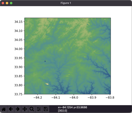
#OpenAthena will now abort a search for a target if the starting altitude is lower than the terrain altitude. This wasn't the case earlier.
This is why I still label my #software as 'pre-alpha'. There are a lot of complicating factors here
OpenAthena.com