In
#archaeology, a “cultural landscape” is a way of enriching our understanding of the ways past peoples moved through, modified, and understood the landscape around them. Let’s apply this concept to the Lewis & Clark Nat’l Historic Trail. A thread 1/20
#pubarch #publichistoryIn the fall of 1800, Peter Fidler and 18 Hudson’s Bay Co. traders established a post called Chesterfield House in the heart of Siksika territory at the confluence of the Saskatchewan and Red Deer Rivers in southern Alberta. 2/18
The Siksika were one of 4 bands of the Niitsítapi, or Blackfoot Confederacy. Their band leader, Ack Ko Mok Ki (a.k.a. “Feathers”) welcomed direct trade with the HBC and supported the endeavor. He even drew this map of the Upper Missouri River country for Fidler in 1801. 3/18
Ack Ko Mok Ki saw Chesterfield House as a boon to his band, allowing direct access to guns and other European manufactured goods, giving his people an advantage over their neighbors. He provided this revised map to Fidler which included the Saskatchewan in 1802. 4/18
Copies of these maps were sent to a London mapmaker named Aaron Arrowsmith. He published a map of North America that included this new intelligence and it was utilized by the Lewis & Clark Expedition in their journey up the Missouri River in 1805. 5/18
A glance at a modern Cartesian representation of the Missouri watershed in Montana reveals some noteworthy differences between Ack Ko Mok Ki’s maps (and subsequently Arrowsmith’s) and how we visualize that river system today. 6/18
For millennia, the Niitsítapi have occupied a territory bounded by the Rocky Mountains to the west, the Great Sand Hills to the east, & the Saskatchewan & Yellowstone rivers to the north & south. These maps highlight culturally significant sites and routes… 7/18
...& do not reflect an ignorance of their own country’s geography & hydrology. They are schematic, like a modern subway map, with a scale based on difficulty of travel rather than linear distance. Tributaries are included based on where they lead, not the water they carry. 8/18
Ergo the front range of the Rockies (known as the mistakis or “backbone” to the Niitsítapi) & the Missouri R. are depicted as straight lines. What is important is how these features relate to one another & places of cultural significance not where they are in Cartesian space 9/18
Fur traders like Peter Fidler understood this, but cartographers in Europe like Aaron Arrowsmith did not. This is how Ack Ko Mok Ki’s maps (which did not use linear scale) were squeezed into a map of North America (which did use linear scale) with very confusing results. 10/18
On June 3rd of 1805, the Lewis and Clark Expedition reached the confluence of the Missouri and Marias Rivers, and spent the next 7 days attempting to figure out which river was the actual Missouri. Spring floods swelling both rivers confounded the problem. 11/18
They possessed a copy of Arrowsmith’s map (& a revised version created by Nicholas King), but the schematic representations of the confluence & the Rocky Mountains, divorced from their cultural context, only added to their confusion, requiring them to scout both branches. 12/18
Mountain peaks & isolated ranges like the sacred Sweet Grass Hills figure on these maps because of their significance to the Niitsítapi, not their geographic prominence. Minor tributaries like the Two Medicine River are named because they lead to places of great importance. 13/18
Modern maps give priority to the much larger Marias (Kiááyoisisaahtaayi, or Bears River to the Niitsítapi, “Ki oo sis sa ta” to Fidler) of which the smaller Two Medicine (”Na too too kase” in Fidler’s notes) is considered one of three tributary streams. 14/18
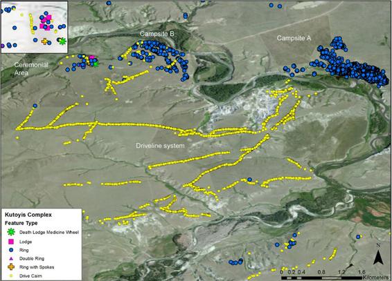
The name belies its import: Nááto'kiookáisisaahtaayi, Nááto'k “two” + ookáán “Sundance” + sisaahtaayi “river”. A pair of sundance lodges once straddled this river, in a valley called Motaátusi, or the Place Where the Bundle Owners Live. It was visited by Lewis in 1806. 15/18
Archaeological investigations at Motaátusi revealed a location of “monumental stone surface architecture” episodically inhabited by the Niitsítapi between 1210 and 1886 CE, with 11 bison drive-line systems and 899 stone circles, each representing a single household. (Figure from: Maria Nieves Zedeño, Jesse A. M. Ballenger, & John R. Murray, “Landscape Engineering & Organizational Complexity among Late Prehistoric Bison Hunters of the Northwestern Plains,” Current Anthropology, 55 Feb 2014)16/18
The modern “Lewis & Clark Trail” cross-cuts a pre-existing cultural landscape, adding another layer of meaning to a place with an already rich and complex history. Read more about it here in my latest article for the L&C Trail Heritage Foundation. 17/18
https://www.academia.edu/52723858/Whats_in_a_Name_Understanding_the_Lewis_and_Clark_Trail_as_a_Cultural_Landscape
What's in a Name? Understanding the Lewis and Clark Trail as a Cultural Landscape
Approaching the Lewis and Clark National Historic Trail as a cultural landscape puts the 1805-1806 Expedition into a broader political, economic, ecological, and cultural context. By including indigenous histories, place names, routes, and land-use
For a deeper treatment of indigenous cartographic traditions and the importance of Native maps to the Lewis & Clark Expedition and the broader invasion of the continent by Euro-American settler-colonists, see here. 18/18
https://www.academia.edu/36854055/Too_N%C3%A9s_World_The_Arikara_Map_and_Native_American_CartographyToo Né's World: The Arikara Map and Native American Cartography
A map drawn in 1805 by an Arikara diplomat sent by the Lewis and Clark Expedition to meet with President Jefferson provides a window into indigenous North American cartographic traditions and the use of Native American maps by the Corps of Discovery
@kmobriant Wow what a thread! My original training was in
#ethnohistory and I used L&C journals in my first book. In 2004 my family participated in the bicentennial hysteria by following the trail from Missouri to the sea--a frequently annoying experience for an ethnohistorian moving into public history!
@larrycebula I've been taking L&C enthusiasts (a.k.a. "Clarkkies") on camping/hikining/canoeing tours on the L&C Trail in Montana and Idaho for the last decade...there are a lot of aspects of the popular narrative that could use some fresh context. Thanks for engaging...I'm going to check out your book now!