For those wondering whether #Ingenuity can walk and chew gum, er, I mean rotate while flying and take pictures, yes it can:

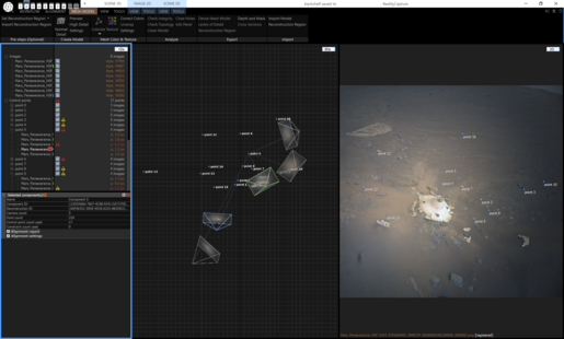
Blue markers are locations from where the #marshelicopter captured RTE images; blue lines point to the projected center of each RTE image on the ground.

#NASA #Perseverance #Mars2020

The last 3 images appear to be targeting closer to the heli; that may be due to a lower altitude, since the RTE camera is fixed on the body. It could also be due to angle changes as a result of velocity changes, but 3 similar in a row are too many for it to be a coincidence.

#Ingenuity #Mars2020 #NASA

@65dBnoise Accuracy is dubious and I don't know if I'll manage to get a useful mesh from it, but I got an alignment in Reality Capture - after manually adding many control points.

Might get some reasonable camera positions / bearings etc. from it, though? Could be useful for mapping purposes!