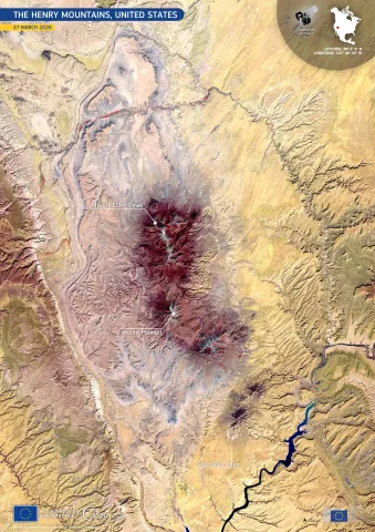
🏜️ Henry Mountains 🇺🇸 seen from space by #CopernicusEU Sentinel-2.
🛰️ This false-colour image highlights desert landscapes, rugged peaks & the winding Colorado River - supporting geological mapping, erosion monitoring analysis.
🏜️ Henry Mountains 🇺🇸 seen from space by #CopernicusEU Sentinel-2.
🛰️ This false-colour image highlights desert landscapes, rugged peaks & the winding Colorado River - supporting geological mapping, erosion monitoring analysis.
🔗 eu-space.europa.eu/component…
#ImageOfTheDay
---
https://nitter.net/CopernicusEU/status/2056066034793169028#m