🏝️ The Bijagós Archipelago 🇬🇼 is a @UNESCO Biosphere Reserve and a vital refuge for mangroves, migratory birds and green sea turtles. 🛰️ This #CopernicusEU Sentinel-2 #ImageOfTheDay reveals its islands, tidal channels and sediment-rich coastal waters. 🔗 https://eu-space.europa.eu/components/earth-observation-copernicus/image-of-the-day/tidal-landscapes-bijagos-archipelago-guinea-bissau
---
https://nitter.net/CopernicusEU/status/2071281577833709900#m
---
https://nitter.net/CopernicusEU/status/2071281577833709900#m
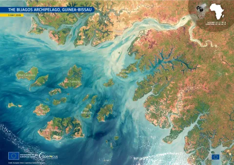
Tidal landscapes of the Bijagós Archipelago, Guinea-Bissau | EU Space Support Office
The Bijagós Archipelago, a system of 88 islands off the coast of Guinea-Bissau in West Africa, has been designated by UNESCO as the Bolama-Bijagós Biosphere Reserve. Its mangroves and surrounding waters support rich birdlife, fish, reptiles, mammals, and important green sea turtle nesting sites are highly sensitive to environmental change.