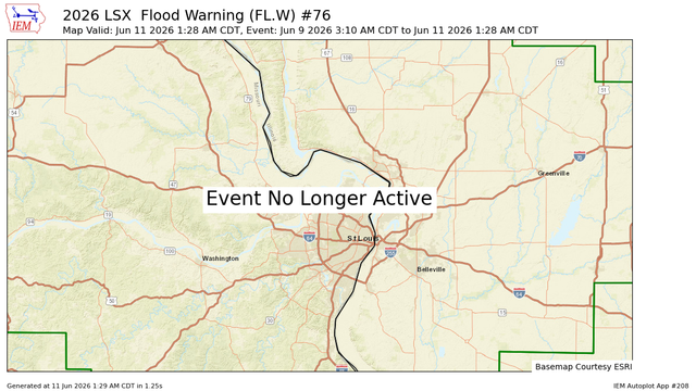
LSX cancels Flood Warning for Missouri River at St. Charles [MO]
https://mesonet.agron.iastate.edu/vtec/f/2026-O-CAN-KLSX-FL-W-0076_2026-06-11T06:28Z
LSX cancels Flood Warning for Missouri River at St. Charles [MO]
https://mesonet.agron.iastate.edu/vtec/f/2026-O-CAN-KLSX-FL-W-0076_2026-06-11T06:28Z
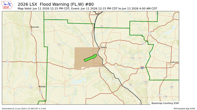
LSX issues Flood Warning valid at Jun 11, 12:15 PM CDT for North River at Palmyra [MO] till Jun 13, 4:00 AM CDT
https://mesonet.agron.iastate.edu/vtec/f/2026-O-NEW-KLSX-FL-W-0080_2026-06-11T17:15Z
The Storm Prediction Center issues Day 1 Enhanced Convective Risk at Jun 11, 6:19z for portions of LSX
https://www.spc.noaa.gov/products/outlook/archive/2026/day1otlk_20260611_1200.html
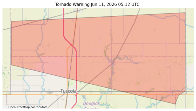
#NWS #tornado Tornado Warning for Champaign, IL; Douglas, IL #ILwx
TORILX
The National Weather Service in Lincoln has issued a
* Tornado Warning for...
Southern Champaign County in east central Illinois...
Northern Douglas County in east central Illinois...
* Until 100 AM CDT.
* At 1212 AM CDT, a severe thunderstorm capable of producing a
tornado was located over Ivesdale, or 9 miles southeast of
Monticello, moving east at 45 mph.
HAZARD...Tornado.
SOURCE...Radar indicated rotation.
IMPACT...Flying debris will be dangerous to those caught without
shelter. Mobile homes will be damaged or destroyed.
Damage to roofs, windows, and vehicles will occur. Tree
damage is likely.
* This dangerous storm will be near...
Ivesdale around 1215 AM CDT.
Pesotum and Sadorus around 1220 AM CDT.
Villa Grove around 1230 AM CDT.
Other locations in the path of this tornadic thunderstorm include
Broadlands.
This includes Interstate 57 between mile markers 214 and 224.
https://forecast.weather.gov/MapClick.php?lon=-88.170&lat=39.890
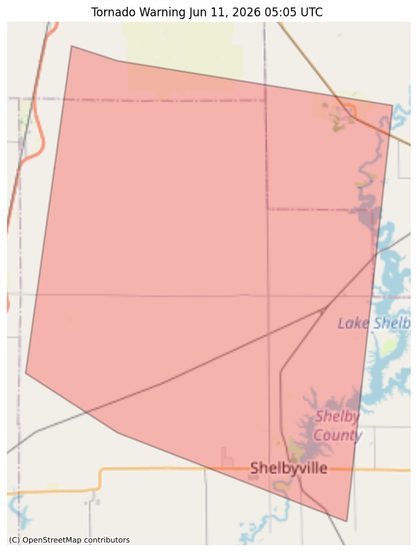
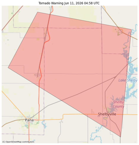
#NWS #tornado Tornado Warning for Macon, IL; Moultrie, IL; Shelby, IL #ILwx
At 1205 AM CDT, a severe squall line capable of producing both
tornadoes and extensive straight line wind damage was located along a
line extending from 7 miles west of Bethany to near Assumption,
moving east at 45 mph.
HAZARD...Tornado.
SOURCE...Radar indicated rotation.
IMPACT...Flying debris will be dangerous to those caught without
shelter. Mobile homes will be damaged or destroyed. Damage
to roofs, windows, and vehicles will occur. Tree damage is
likely.
These dangerous storms will be near...
Bethany and Findlay around 1210 AM CDT.
Shelbyville around 1215 AM CDT.
Other locations impacted by these tornadic storms include Westervelt.
https://forecast.weather.gov/MapClick.php?lon=-88.856&lat=39.539
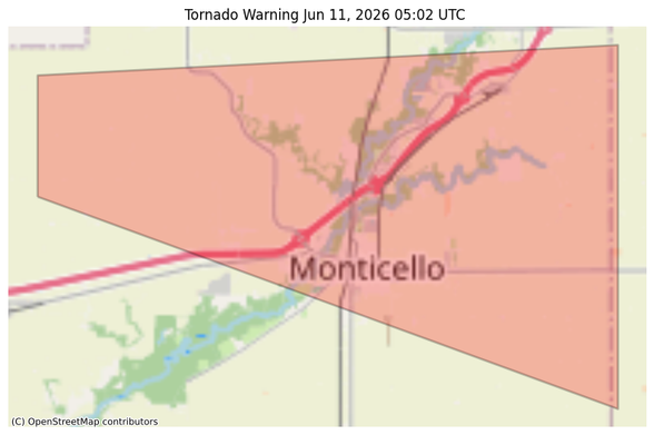
#NWS #tornado Tornado Warning for Piatt, IL #ILwx
At 1202 AM CDT, a confirmed tornado was located near De Land, or near
Monticello, moving east at 35 mph.
HAZARD...Damaging tornado.
SOURCE...Public confirmed tornado.
IMPACT...Flying debris will be dangerous to those caught without
shelter. Mobile homes will be damaged or destroyed. Damage
to roofs, windows, and vehicles will occur. Tree damage is
likely.
This tornado will be near...
Monticello around 1205 AM CDT.
White Heath around 1210 AM CDT.
This includes Interstate 72 between mile markers 162 and 171.
https://forecast.weather.gov/MapClick.php?lon=-88.564&lat=40.053
#NWS #tornado Tornado Warning for Macon, IL; Moultrie, IL; Shelby, IL #ILwx
At 1202 AM CDT, a severe thunderstorm capable of producing a tornado
was located near Dalton City, or 10 miles south of Decatur, moving
east at 45 mph.
HAZARD...Tornado.
SOURCE...Radar indicated rotation.
IMPACT...Flying debris will be dangerous to those caught without
shelter. Mobile homes will be damaged or destroyed. Damage
to roofs, windows, and vehicles will occur. Tree damage is
likely.
This dangerous storm will be near...
Dalton City around 1205 AM CDT.
Bethany around 1210 AM CDT.
Other locations impacted by this tornadic thunderstorm include Hervey
City and Lake City.
https://forecast.weather.gov/MapClick.php?lon=-88.815&lat=39.715
#NWS #tornado Tornado Warning for Christian, IL; Macon, IL; Moultrie, IL; Shelby, IL #ILwx
At 1157 PM CDT, a severe squall line capable of producing both
tornadoes and extensive straight line wind damage was located along a
line extending from near Moweaqua to Assumption, moving east at 45
mph.
HAZARD...Tornado.
SOURCE...Radar indicated rotation.
IMPACT...Flying debris will be dangerous to those caught without
shelter. Mobile homes will be damaged or destroyed. Damage
to roofs, windows, and vehicles will occur. Tree damage is
likely.
These dangerous storms will be near...
Bethany and Findlay around 1210 AM CDT.
Shelbyville around 1215 AM CDT.
Other locations impacted by these tornadic storms include Westervelt.
https://forecast.weather.gov/MapClick.php?lon=-88.899&lat=39.547
#NWS #tornado Tornado Warning for Piatt, IL #ILwx
At 1157 PM CDT, a severe thunderstorm capable of producing a tornado
was located near Cerro Gordo, or 10 miles southwest of Monticello,
moving east at 45 mph.
HAZARD...Tornado.
SOURCE...Radar indicated rotation.
IMPACT...Flying debris will be dangerous to those caught without
shelter. Mobile homes will be damaged or destroyed. Damage
to roofs, windows, and vehicles will occur. Tree damage is
likely.
This dangerous storm will be near...
Bement and Cerro Gordo around 1200 AM CDT.
Other locations impacted by this tornadic thunderstorm include
Milmine.
https://forecast.weather.gov/MapClick.php?lon=-88.589&lat=39.902
Storm Prediction Center issues Mesoscale Discussion #1081 concerning SEVERE THUNDERSTORM WATCH 309 [Most Prob: Tornado: UP TO 90 MPH, Hail: UP TO 1.25 IN, Gust: 65-80 MPH]