Fires nearby but not too close. fire season here.
#TroutFire New Mexico
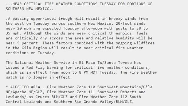
This area has a #RedFlagWarning
Never ignore an order to evacuate. The fire officials have information that you do not.
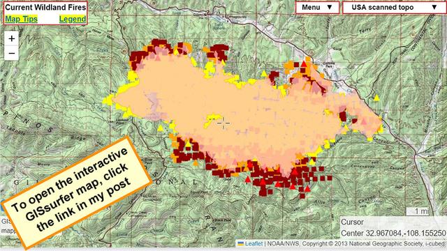
The symbols on the map are heat detections from MODIS and VIIRS satellites. This data is *not* real time and locations are approximate. Sometimes this data is ‘false positive’.
This data updates several times during the day. To read more about this kind of data, open the map and click “Map tips” in the upper left corner.
To search on an address click Menu > Search.
If you open the map and then zoom in another good basemap to look at is ‘Open Topo Map’.
#Wildfire #NMfire #NMwx
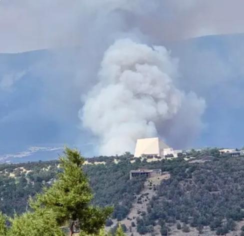
Fire in Ruidoso, NM near Fort Stanton. Evacuations requested for local residents. This is the only place I could find information.
https://app.watchduty.org/i/49416
#nm #ruidoso #nmfire #ruidosofire
https://app.watchduty.org/i/49416
#nm #ruidoso #nmfire #ruidosofire
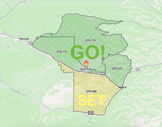
Grant Tosterod (KRQE): ⚠️ Evacuations have been ordered for the residents that live north of Highway 82, including Mayhill, due to the Gail Fire in the Sacramento Mountains. Evacuees can go to the Cloudcroft High School. #NMFire #NMwx
https://bsky.app/profile/granttosterud.bsky.social/post/3lkp3grj6as2w

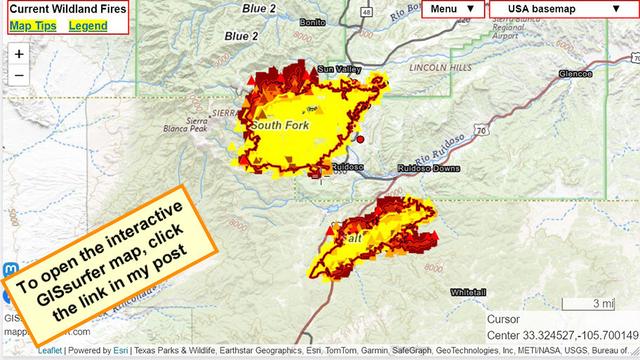
Thursday. There are now updated fire perimeters from a flight that I think was a bit before mid-day.
EDIT: I initially read the acreages wrong. Sorry!
**Corrected** #SouthForkFire 16,335 acres
**Corrected** #SaltFire 7,652 acres
To search on an address open the map and tap/click Menu > Search and enter the address.
Zoom in and road names appear.
#NMfire #NMwx #WildFire
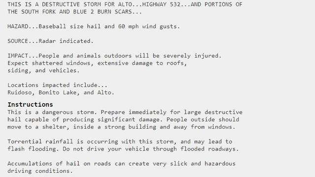
Via Grant Tosterud/KRQE ⚠️ A FLASH FLOOD EMERGENCY is in effect for areas upstream of Ruidoso and Ruidoso Downs. Catastrophic flash flooding is possible in western Ruidoso. Evacuate immediately to higher ground! Radar estimating 2"+ of rain has already fallen. #NMwx #NMFire
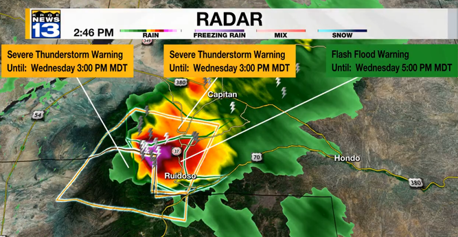
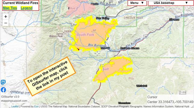
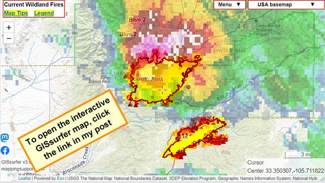
Severe thunderstorm and heavy rain. Damaging hail.
#SouthForkFire and #Blue2Fire scar.
#NMfire #NMwx #WildFire
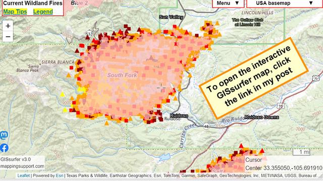
The red/black line on this map is the perimeter determined by an infrared flight at 11:59pm Tuesday night. The IR analyst determined acreages.
#SouthForkFire 16,335 acres. Yesterday some higher acreage numbers were in the data. I do not know the reason for difference.
#SaltFire 7,071 acres
If you zoom in, street names will appear. You can also tap/click Menu > Search and enter an address.
To get the most benefit from the map please see 2 links upper left corner.
#NMfire #NMwx #WildFire
The perimeter for the #Southforkfire has been updated. 19,985 acres.
Dark red symbols are the most recent MODIS and VIIRS satellite heat detections. Not real time and locations are only approximate.
Open the map and zoom in for street names. You can also click Menu > Search and enter an address.
Yes, homes were lost but not all buildings inside the perimeter burned! Crews were doing structure protection. Also if a building had enough cleared area around it then maybe it survived.
#NMfire #NMwx #WildFire
“Mapping the South Fork Fire in New Mexico”
Gift link: https://wapo.st/45y0QKY
