The Weather Prediction Center issues Day 5 Marginal Risk Excessive Rainfall Outlook at Mar 31, 8:35z for portions of DTX
https://www.wpc.ncep.noaa.gov/qpf/excessive_rainfall_outlook_ero.php
The Weather Prediction Center issues Day 5 Marginal Risk Excessive Rainfall Outlook at Mar 31, 8:35z for portions of DTX
https://www.wpc.ncep.noaa.gov/qpf/excessive_rainfall_outlook_ero.php
#DTX #MIwx 093
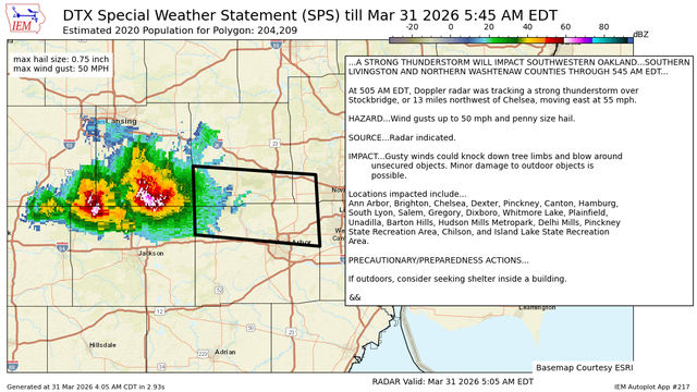
WWUS83 KDTX 310905
SPSDTX
Special Weather Statement
National Weather Service Detroit/Pontiac MI
505 AM EDT Tue Mar 31 2026
MIZ068-069-075-310945-
Livingston MI-Oakland MI-Washtenaw MI-
505 AM EDT Tue Mar 31 2026
...A STRONG THUNDERSTORM WILL IMPACT SOUTHWESTERN OAKLAND...SOUTHERN
LIVINGSTON AND NORTHERN WASHTENAW COUNTIES THROUGH 545 AM EDT...
At 505 AM EDT, Doppler radar was tracking a strong thunderstorm over
Stockbridge, or 13 miles northwest of https://mesonet.agron.iastate.edu/p.php?pid=202603310905-KDTX-WWUS83-SPSDTX
DTX issues A STRONG THUNDERSTORM WILL IMPACT SOUTHWESTERN OAKLANDSOUTHERN LIVINGSTON AND NORTHERN WASHTENAW COUNTIES THROUGH 545 AM EDT [wind: 50 MPH, hail: 0.75 IN]
https://mesonet.agron.iastate.edu/p.php?pid=202603310905-KDTX-WWUS83-SPSDTX
#DTX #MIwx 586
FLUS43 KDTX 310837
HWODTX
Hazardous Weather Outlook
National Weather Service Detroit/Pontiac MI
437 AM EDT Tue Mar 31 2026
MIZ047>049-053>055-060>063-068>070-075-076-082-083-010845-
Midland-Bay-Huron-Saginaw-Tuscola-Sanilac-Shiawassee-Genesee-Lapeer-
St. Clair-Livingston-Oakland-Macomb-Washtenaw-Wayne-Lenawee-Monroe-
437 AM EDT Tue Mar 31 2026
This hazardous weather outlook is for southeast Michigan.
.DAY ONE...Today and Tonight
There is a Slight Ri https://mesonet.agron.iastate.edu/p.php?pid=202603310837-KDTX-FLUS43-HWODTX
DTX issues Hazardous Weather Outlook (HWO) at Mar 31, 4:37 AM EDT
https://mesonet.agron.iastate.edu/p.php?pid=202603310837-KDTX-FLUS43-HWODTX
The Weather Prediction Center issues Day 1 Slight Risk Excessive Rainfall Outlook at Mar 31, 7:53z for portions of DTX
https://www.wpc.ncep.noaa.gov/qpf/excessive_rainfall_outlook_ero.php
The Weather Prediction Center issues Day 3 Marginal Risk Excessive Rainfall Outlook at Mar 31, 7:53z for portions of DTX
https://www.wpc.ncep.noaa.gov/qpf/excessive_rainfall_outlook_ero.php
#DTX #MIwx 341
FZUS73 KDTX 310813
MWSDTX
Marine Weather Statement
National Weather Service Detroit/Pontiac MI
413 AM EDT Tue Mar 31 2026
LHZ421-422-310915-
413 AM EDT Tue Mar 31 2026
...A STRONG THUNDERSTORM APPROACHING THE WATERS...
The areas affected include...
Inner Saginaw Bay SW of Point Au Gres to Bay Port MI...
Outer Saginaw Bay SW of Alabaster to Port Austin MI to Inner
Saginaw Bay...
At 412 AM EDT, Doppler radar indicated a strong thunderstorm,
ca https://mesonet.agron.iastate.edu/p.php?pid=202603310813-KDTX-FZUS73-MWSDTX