DTX expires Severe Thunderstorm Warning for Bay [MI]
https://mesonet.agron.iastate.edu/vtec/f/2026-O-EXP-KDTX-SV-W-0074_2026-06-16T20:40Z
DTX expires Severe Thunderstorm Warning for Bay [MI]
https://mesonet.agron.iastate.edu/vtec/f/2026-O-EXP-KDTX-SV-W-0074_2026-06-16T20:40Z
#DTX #MIwx 249
WWUS53 KDTX 162040
SVSDTX
Severe Weather Statement
National Weather Service Detroit/Pontiac MI
440 PM EDT Tue Jun 16 2026
MIC017-162050-
/O.EXP.KDTX.SV.W.0074.000000T0000Z-260616T2045Z/
Bay MI-
440 PM EDT Tue Jun 16 2026
...THE SEVERE THUNDERSTORM WARNING FOR CENTRAL BAY COUNTY WILL EXPIRE
AT 445 PM EDT...
The storm which prompted the warning has moved out of the area.
Therefore, the warning will be allowed to expire.
&&
LAT...LON 4392 8388 4383 83 https://mesonet.agron.iastate.edu/vtec/f/2026-O-EXP-KDTX-SV-W-0074_2026-06-16T20:40Z
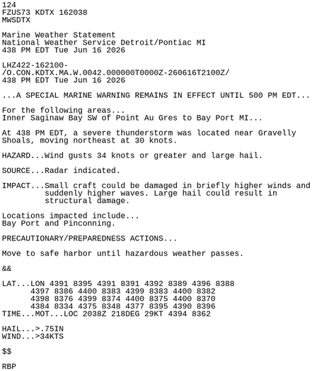
#DTX #MIwx 124
FZUS73 KDTX 162038
MWSDTX
Marine Weather Statement
National Weather Service Detroit/Pontiac MI
438 PM EDT Tue Jun 16 2026
LHZ422-162100-
/O.CON.KDTX.MA.W.0042.000000T0000Z-260616T2100Z/
438 PM EDT Tue Jun 16 2026
...A SPECIAL MARINE WARNING REMAINS IN EFFECT UNTIL 500 PM EDT...
For the following areas...
Inner Saginaw Bay SW of Point Au Gres to Bay Port MI...
At 438 PM EDT, a severe thunderstorm was located near Gravelly
Shoals, moving northeast at https://mesonet.agron.iastate.edu/p.php?pid=202606162038-KDTX-FZUS73-MWSDTX
#DTX #MIwx 124
FZUS73 KDTX 162038
MWSDTX
Marine Weather Statement
National Weather Service Detroit/Pontiac MI
438 PM EDT Tue Jun 16 2026
LHZ422-162100-
/O.CON.KDTX.MA.W.0042.000000T0000Z-260616T2100Z/
438 PM EDT Tue Jun 16 2026
...A SPECIAL MARINE WARNING REMAINS IN EFFECT UNTIL 500 PM EDT...
For the following areas...
Inner Saginaw Bay SW of Point Au Gres to Bay Port MI...
At 438 PM EDT, a severe thunderstorm was located near Gravelly
Shoals, moving northeast at https://mesonet.agron.iastate.edu/vtec/f/2026-O-CON-KDTX-MA-W-0042_2026-06-16T20:38Z
DTX continues Marine Warning [wind: >34 KTS, hail: >.75 IN] for Inner Saginaw Bay SW of Point Au Gres to Bay Port MI [LH] till 5:00 PM EDT
https://mesonet.agron.iastate.edu/vtec/f/2026-O-CON-KDTX-MA-W-0042_2026-06-16T20:38Z
#DTX #MIwx 755
WHUS53 KDTX 162036
SMWDTX
LHZ421-441-462-162130-
/O.NEW.KDTX.MA.W.0043.260616T2036Z-260616T2130Z/
BULLETIN - IMMEDIATE BROADCAST REQUESTED
Special Marine Warning
National Weather Service Detroit/Pontiac MI
436 PM EDT Tue Jun 16 2026
The National Weather Service in Detroit/Pontiac has issued a
* Special Marine Warning for...
Lake Huron from Port Austin to Harbor Beach 5NM Off Shore to the
US/Canadian border...
Outer Saginaw Bay SW of Alabaster to https://mesonet.agron.iastate.edu/vtec/f/2026-O-NEW-KDTX-MA-W-0043_2026-06-16T20:36Z
DTX issues Marine Warning [wind: >34 KTS, hail: >.75 IN] for Lake Huron from Port Austin to Harbor Beach 5NM Off Shore to the US/Canadian border, Outer Saginaw Bay SW of Alabaster to Port Austin MI to Inner Saginaw Bay, Port Austin to Harbor Beach MI [LH] till 5:30 PM EDT
https://mesonet.agron.iastate.edu/vtec/f/2026-O-NEW-KDTX-MA-W-0043_2026-06-16T20:36Z
#APX #MIwx 047
WWUS83 KAPX 162035
SPSAPX
Special Weather Statement
National Weather Service Gaylord MI
435 PM EDT Tue Jun 16 2026
MIZ021-099-162115-
Antrim MI-Charlevoix MI-
435 PM EDT Tue Jun 16 2026
...A STRONG THUNDERSTORM WILL IMPACT NORTHEASTERN ANTRIM AND
SOUTHEASTERN CHARLEVOIX COUNTIES THROUGH 515 PM EDT...
At 434 PM EDT, Doppler radar was tracking a strong thunderstorm near
Jordan Township, or near East Jordan, moving northeast at 30 mph.
HAZARD...Wind g https://mesonet.agron.iastate.edu/p.php?pid=202606162035-KAPX-WWUS83-SPSAPX
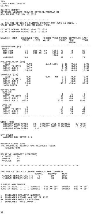
#DTX #MIwx 279
CDUS43 KDTX 162034
CLIMBS
CLIMATE REPORT
NATIONAL WEATHER SERVICE DETROIT/PONTIAC MI
434 PM EDT TUE JUN 16 2026
...................................
...THE TRI CITIES MI CLIMATE SUMMARY FOR JUNE 16 2026...
VALID TODAY AS OF 0400 PM LOCAL TIME.
CLIMATE NORMAL PERIOD 1991 TO 2020
CLIMATE RECORD PERIOD 1912 TO 2026
WEATHER ITEM OBSERVED TIME RECORD YEAR NORMAL DEPARTURE LAST
VALUE (LST) VALUE VALUE FROM YEAR https://mesonet.agron.iastate.edu/p.php?pid=202606162034-KDTX-CDUS43-CLIMBS
#DTX #MIwx 275
CDUS43 KDTX 162034
CLIFNT
CLIMATE REPORT
NATIONAL WEATHER SERVICE DETROIT/PONTIAC MI
434 PM EDT TUE JUN 16 2026
...................................
...THE FLINT MI CLIMATE SUMMARY FOR JUNE 16 2026...
VALID TODAY AS OF 0400 PM LOCAL TIME.
CLIMATE NORMAL PERIOD 1991 TO 2020
CLIMATE RECORD PERIOD 1921 TO 2026
WEATHER ITEM OBSERVED TIME RECORD YEAR NORMAL DEPARTURE LAST
VALUE (LST) VALUE VALUE FROM YEAR
https://mesonet.agron.iastate.edu/p.php?pid=202606162034-KDTX-CDUS43-CLIFNT