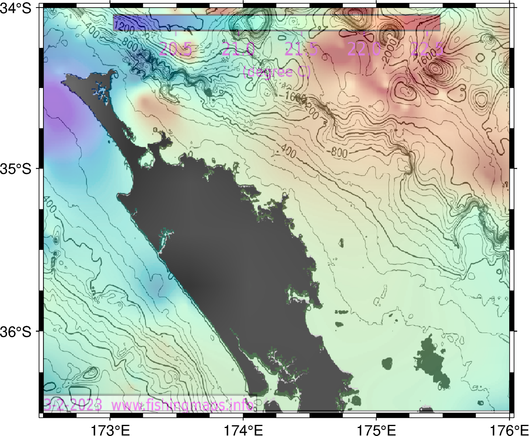
Producing fishing maps for recreational game fishers yields some fascinating patterns in SST, geostrophic currents and chlorophyll. Here is a hot spot in SST associated with an cyclonic (anticlockwise) eddy of a counter-rotating eddy pair in the Bay of Cadiz south of Portugal, where they fish for tunas. Almost no chlorophyll associated with the hotspot.

https://www.fishingmaps.info

#fisheries #ocean #oceanography # tuna #GameFishing #SeaSurfaceTemperature

SST fishing maps for deep sea big game fishing

SST bathymetry fishing maps help fishers find big game fish. We provide detailed cloud-free SST bathymetry maps, updated daily, for the price of a cup of coffee.

I've been looking into why Waihau Bay near the East Cape of New Zealand is such a good location for recreational Southern Bluefin Tuna fishing. After working in California for 11 years, the sparsity of oceanographic information about the region is startling for me.
#oceanography #fisheries #GameFishing #tuna #BlueFinTuna #eddies #canyons #SecondaryProduction #pilchards #krill #Sardines

Moving on to producing fishing maps for U.S. and Central American game fishing regions now (https://www.fishingmaps.info). This one is for Puerto Quetzal, Guatemala. There's an impressive cross-shelf canyon where they fish for Pacific Sailfish at this time of year. These maps show the most recent 4 days of SST overlaid on bathymetry.

#fisheries #oceanography #GameFishing #SST #SeaSurfaceTemperature #maps

SST fishing maps for deep sea big game fishing

SST bathymetry fishing maps help fishers find big game fish. We provide detailed cloud-free SST bathymetry maps, updated daily, for the price of a cup of coffee.

After spending most of my 35-year career in fisheries oceanography working on fisheries sustainability science, I have now turned my hand to helping game fishers catch tunas and marlin. There are times when I think that I've gone to the dark side, but the problem is interesting, and there are management measures in place for these recreational fisheries.

https://towardsdatascience.com/day-to-day-variability-in-sea-surface-temperature-sst-fishing-maps-af9bc04bb260?source=friends_link&sk=6c18df0c60cc190207904ddb1c2f0e4e

#fisheries #oceanography #GameFishing #FishingMaps #SST #SeaSurfaceTemperature #bathymetry

Day-to-Day Variability in Sea Surface Temperature (SST) Fishing Maps

The fisher’s dilemma has always been where and when to find fish. There are many cues on and over the ocean that help fishers locate big game fish like tunas and marlin. These include the season and…

Towards Data Science

This is an SST/ bathymetry map of Cabo Verde off West Africa (Sao Vicente Island in the middle), which is one of the best spots for blue marlin game fishing. No wonder! Look at the bathymetry and the temperature contrasts. (Looks like I have a minor problem with the land mask in the overlaid images).

#fisheries #oceanography #SeaSurfaceTemperature #RemoteSensing #satellite #bathymetry #GameFishing #marlin #sailfish #swordfish #tuna #LargePelagicFish