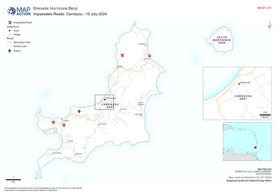
This map of impassable roads in Carriacou, Grenada, helps humanitarian agencies plot a route to deliver aid to affected communities. More insights in our daily blog on #HurricaneBeryl #Ready2Respond #GIS4Good
https://mapaction.org/live-blog-2024-hurricane-season/
Live updates*: 60,000 people estimated to be in need of humanitarian assistance in Grenada and St Vincent and the Grenadines – MapAction

Movement ecology paper on elephant spatial selection in the Maasai Mara, much of the analysis leveraged Ecoscope (https://ecoscope.io/), tech we are bringing into the EarthRanger platform https://link.springer.com/article/10.1186/s40462-023-00436-8 #data4good #gis4good
Ecoscope — Ecoscope Docs

New #MapAction members undertake a simulated response to an earthquake as part of operational readiness training to be able to later deploy as humanitarian mappers. #training #disasterpreparedness #GIS4Good
Celebrating 10 years of #partnership and shared values with CartONG to unlock information barriers for humanitarian responders. #GIS4Good #humanitarianGIS #disasterresilience https://mapaction.org/ode-to-a-geospatial-humanitarian-partnership-and-shared-values/
Ode to a geospatial humanitarian partnership and shared values – MapAction