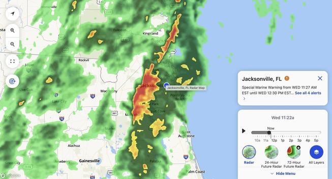
Always a kick when we have legit thunderstorms in December #FLWeather

#FLweather #FLwx
638
FXUS62 KJAX 210018
AFDJAX

Area Forecast Discussion
National Weather Service Jacksonville FL
718 PM EST Tue Feb 20 2024

...New UPDATE...

.UPDATE...
Issued at 712 PM EST Tue Feb 20 2024

Forecast remains on track through tonight with patchy to areas of
frost forming over inland areas in the early morning hours.

&&

.NEAR TERM...
Issued at 219 PM EST Tue Feb 20 2024

For the latest NE FL an https://mesonet.agron.iastate.edu/p.php?pid=202402210018-KJAX-FXUS62-AFDJAX

IEM :: AFD from NWS JAX

AFD issued by NWS JAX at 21 Feb 2024 00:18 UTC

#FLweather #FLwx
938
FLUS42 KMLB 210002
HWOMLB

Hazardous Weather Outlook
National Weather Service Melbourne FL
700 PM EST Tue Feb 20 2024

AMZ550-552-555-570-572-575-FLZ041-044>046-053-058-141-144-154-159-
164-247-254-259-264-347-447-547-647-747-210800-
Flagler Beach to Volusia-Brevard County Line 0-20 nm-Volusia-
Brevard County Line to Sebastian Inlet 0-20 nm-
Sebastian Inlet to Jupiter Inlet 0-20 nm-Flagler Be https://mesonet.agron.iastate.edu/p.php?pid=202402210000-KMLB-FLUS42-HWOMLB

IEM :: HWO from NWS MLB

HWO issued by NWS MLB at 21 Feb 2024 00:00 UTC

#FLweather #FLwx
769
FXUS62 KMFL 202355
AFDMFL

Area Forecast Discussion
National Weather Service Miami FL
655 PM EST Tue Feb 20 2024

...New UPDATE, AVIATION...

.UPDATE...
Issued at 654 PM EST Tue Feb 20 2024

No mjaor changes to the forecast this evening. Dewpoints continue
to run below most guidance solutions. Will continue to monitor
trends in case temperatures start to decrease faster here after
sunset.

&& https://mesonet.agron.iastate.edu/p.php?pid=202402202355-KMFL-FXUS62-AFDMFL

IEM :: AFD from NWS MFL

AFD issued by NWS MFL at 20 Feb 2024 23:55 UTC

#FLweather #FLwx
178
NOUS42 KMLB 202019
PNSMLB
FLZ041-044>046-053-058-141-144-154-159-164-247-254-259-264-347-447-547-647-747-210819-

Public Information Statement
National Weather Service Melbourne FL
319 PM EST Tue Feb 20 2024

...FEBRUARY 16-19, 2024 PRECIPITATION REPORTS...

Location Amount Time/Date Provider

...Florida...

...Brevard County...
Indialantic 3.3 NNW https://mesonet.agron.iastate.edu/p.php?pid=202402202019-KMLB-NOUS42-PNSMLB

IEM :: PNS from NWS MLB

PNS issued by NWS MLB at 20 Feb 2024 20:19 UTC

#FLweather #FLwx
026
FLUS42 KMFL 202006
HWOMFL

Hazardous Weather Outlook
National Weather Service Miami FL
306 PM EST Tue Feb 20 2024

AMZ610-630-650-651-670-671-FLZ063-066>075-168-172>174-GMZ656-657-676-
212015-
Lake Okeechobee-Biscayne Bay-
Coastal waters from Jupiter Inlet to Deerfield Beach FL out 20 NM-
Coastal waters from Deerfield Beach to Ocean Reef FL out 20 NM-
Waters from Jupiter Inlet to Deerfield Be https://mesonet.agron.iastate.edu/p.php?pid=202402202006-KMFL-FLUS42-HWOMFL

IEM :: HWO from NWS MFL

HWO issued by NWS MFL at 20 Feb 2024 20:06 UTC

#FLweather #FLwx
529
FXUS62 KTAE 202004
AFDTAE

Area Forecast Discussion
National Weather Service Tallahassee FL
304 PM EST Tue Feb 20 2024

...New NEAR TERM, SHORT TERM, LONG TERM, MARINE, FIRE WEATHER, HYDROLOGY...

.NEAR TERM...
(Through Wednesday)
Issued at 159 PM EST Tue Feb 20 2024

Weak upper level ridging and surface high pressure dominate the
forecast through Wednesday. This will lead to quiet and dry w https://mesonet.agron.iastate.edu/p.php?pid=202402202004-KTAE-FXUS62-AFDTAE

IEM :: AFD from NWS TAE

AFD issued by NWS TAE at 20 Feb 2024 20:04 UTC

#FLweather #FLwx
020
FXUS62 KMLB 202003
AFDMLB

Area Forecast Discussion
National Weather Service Melbourne FL
303 PM EST Tue Feb 20 2024

...New DISCUSSION, MARINE, FIRE WEATHER, AVIATION...

.DISCUSSION...
Issued at 245 PM EST Tue Feb 20 2024

Tonight-Wednesday...Satellite imagery this afternoon shows a few
clouds offshore and clear conditions over the Florida Peninsula.
Temperatures have warmed into the mid to https://mesonet.agron.iastate.edu/p.php?pid=202402202003-KMLB-FXUS62-AFDMLB

IEM :: AFD from NWS MLB

AFD issued by NWS MLB at 20 Feb 2024 20:03 UTC

#FLweather #FLwz
627
FXUS62 KTBW 202000
AFDTBW

Area Forecast Discussion
National Weather Service Tampa Bay Ruskin FL
300 PM EST Tue Feb 20 2024

...New DISCUSSION, AVIATION, MARINE, FIRE WEATHER...

.DISCUSSION...
Issued at 300 PM EST Tue Feb 20 2024

High pressure will continue to dominate into Thursday with fair
dry weather persisting. It's looking like another rather chilly
night under clear skies with tempe https://mesonet.agron.iastate.edu/p.php?pid=202402202000-KTBW-FXUS62-AFDTBW

IEM :: AFD from NWS TBW

AFD issued by NWS TBW at 20 Feb 2024 20:00 UTC

#FLweather #FLwx
346
FXUS62 KMFL 201947
AFDMFL

Area Forecast Discussion
National Weather Service Miami FL
247 PM EST Tue Feb 20 2024

...New LONG TERM...

.SHORT TERM...
(Rest of today through Wednesday)
Issued at 1206 PM EST Tue Feb 20 2024

A gorgeous afternoon and evening will prevail across South Florida
today. Winding back the clock for a few hours, the 12z MFL upper air
sounding showed a cool and dry air https://mesonet.agron.iastate.edu/p.php?pid=202402201947-KMFL-FXUS62-AFDMFL

IEM :: AFD from NWS MFL

AFD issued by NWS MFL at 20 Feb 2024 19:47 UTC