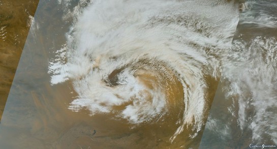
Severe TC #Darian 🌀 moving west across the southern Indian Ocean, seen by #Himawari8 🛰️.
Category 5 on Aussie scale (119 knots 10 min sustained winds)
Cat 4 on the Saffir Simpson scale 130 kt (1 min sust. winds).
On the #CycloneScale it is an eta class TC #ηclass #ηclassTC
Super Typhoon #Chanthu (#KikoPH) has been assessed by JTWC as having 155 knots 1 minute sustained winds (178 mph, 287 km/h) that's iota class on the #CycloneScale capable of extraordinary damage. Striking Batanes for the next several hours. #TyphoonChanthu #ιclass #ιclassTC
Excellent ASCAT pass 1040 UTC 24 Aug over the Australian east coast cyclone ongoing showing widespread 50 kt SSW winds on western flank of the storm, not all rain-flagged. Giant surf! #βclass #CycloneScale
Typhoon In-fa 🌀core approaching the Sakishima Islands (先島諸島) with 1 min estimated sustained winds of 85 knots which makes it a delta class tropical cyclone on the #CycloneScale #δclassTC #TyphoonInfa #FabianPH
Extremely Severe Cyclonic Storm #Tauktae with 110 kts 1 min winds according to JTWC, satellite estimates 130 knots (category 4 on the saffir simpson scale) that's eta class on the #CycloneScale #ηclassTC heading for very damaging landfall in Gujarat this evening, video update later today #CycloneTauktae
#Tauktae 🌀has been gradually intensifying, now gamma class (cat 1 hurricane), or a severe cyclonic storm on the N. Indian Ocean scale. Centre just offshore, must be tropical storm conditions at the coast. #CycloneTauktae #γclassTC #CycloneScale
Cyclonic Storm #Tauktae seen by #Himawari8 today with estimated 1-minute sustained winds of 50 kts is a beta-class tropical cyclone on the #CycloneScale #βclassTC NICT edit see latest imagery at http://himawari.asia). #CycloneTauktae
Himawari-8 Real-time Web - NICT

The Himawari-8 Real-time Web is an application via big-data technologies developed by the NICT Science Cloud project in NICT (National Institute of Information and Communications Technology), Japan. Development is in collaboration with JMA (Japan Meteorological Agency) and CEReS (Center of Environmental Remote Sensing, Chiba University).

Possible alpha class mesoscale cyclone🌀at the southern NSW coast rolled off a large warm ocean eddy this evening. A similar feature enhanced by an warm eddy was simulated in https://bit.ly/3heDiTZ and https://bit.ly/33vHnLy #αclassST #αclassMC #cyclonescale
(PDF) Sea level pressure response to the specification of eddy-resolving sea surface temperature in simulations of Australian east coast lows

PDF | Four east coast lows (ECLs) were simulated with the Weather Research and Forecast model to investigate the influence of the sea surface... | Find, read and cite all the research you need on ResearchGate

Estimated beta class extratropical cyclone picked up a huge swirl of dust over northern China yesterday as seen by #Sentinel3 #βclassET #CycloneScale