#DragonBravoFire in Arizona is really cooking today. Dark symbols are heat detections by satellite within prior 6 hours. To learn more about the data the map can display, open the map and see 2 links in the upper left corner.
#Wildfire #AZfire #AZwx

Open GISsurfer map:
https://mappingsupport.com/p2/gissurfer.php?center=36.390473,-112.042007&zoom=12&basemap=USA_scanned_topo&overlay=VIIRS_7_day,MODIS_7_day,State_boundary,Perimeter_WFGIS_current&data=https://mappingsupport.com/p2/special_maps/disaster/USA_wildland_fire.txt

#DragonBravoFire at north rim of the #GrandCanyon, Arizona. This is at the end of state highway 67.

In the screenshot I posted you can see that a burnout operation has happened at the north edge of the fire. That is the narrow pink area that is part of the perimeter which defines the area that has burned.

The symbols on the map are heat detections from MODIS and VIIRS satellites. This data is *not* real time and locations are approximate. Sometimes this data is ‘false positive'.

This data updates several times during the day. To read more about this kind of data, open the map and click "Map tips" in the upper left corner.
#Wildfire #AZfire #AZwx

Open GISsurfer map:
https://mappingsupport.com/p2/gissurfer.php?center=36.219141,-112.084751&zoom=13&basemap=Open_Topo_Map&overlay=VIIRS_7_day,MODIS_7_day,State_boundary,Perimeter_WFGIS_current&data=https://mappingsupport.com/p2/special_maps/disaster/USA_wildland_fire.txt

#DragonBravoFire at north rim of the #GrandCanyon, Arizona. This is at the end of state highway 67.

The symbols on the map are heat detections from MODIS and VIIRS satellites. This data is *not* real time and locations are approximate. Sometimes this data is ‘false positive'.

This data updates several times during the day. To read more about this kind of data, open the map and click "Map tips" in the upper left corner.
#Wildfire #AZfire #AZwx

Open GISsurfer map:
https://mappingsupport.com/p2/gissurfer.php?center=36.219141,-112.084751&zoom=13&basemap=Open_Topo_Map&overlay=VIIRS_7_day,MODIS_7_day,State_boundary,Perimeter_WFGIS_current&data=https://mappingsupport.com/p2/special_maps/disaster/USA_wildland_fire.txt

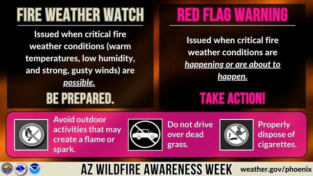
#AZwx #CochiseCounty #Firewx

From Arizona Department of Forestry and Fire Management on FB:

***Update - #StrongholdFire

The fire is being reported at 283 acres, moving to the northeast, and remains very active. Additional resources have been ordered including two Large Air Tankers, two Single Engine Air Tankers, four engines, the Globe Hotshots, and overhead.

Currently four Arizona Forestry crews remain assigned along with state, federal, and local engines.

Per at Cochise County Sheriff's Office - Mark J. Dannels Sheriff: GO for homes west of Cochise Stronghold and south of Ironwood Roads in Sunsites. If residents need assistance with evacuating large animals, they can call SEACOM and CCSO Ranch Patrol will assist.

All evacuation information will come from the Cochise County Sheriff's Office.

The fire is located approximately 16 miles south of Cochise.

#AZFire #AZForestry

A Fire Weather Watch means critical fire weather conditions are possible and a Red Flag Warning means they are happening or are imminent. When these products are in effect please avoid any activities that may create a flame or spark. #SouthwestWildfireAwarenessWeek #AZFire https://t.co/RSDPcXFy1V

Mar 26, 09:00am -0700

NWS Phoenix (@NWSPhoenix) on X

A Fire Weather Watch means critical fire weather conditions are possible and a Red Flag Warning means they are happening or are imminent. When these products are in effect please avoid any activities that may create a flame or spark. #SouthwestWildfireAwarenessWeek #AZFire

X (formerly Twitter)

#BoulderViewFire is on the north side of the greater Phoenix area.

If you are seeing one of my fire maps for the first time, there are two links in the upper left corner to help you get the most benefit from the map.
#AZfire #AZwx #Wildfire

Open GISsurfer map:
https://mappingsupport.com/p2/gissurfer.php?center=33.818157,-111.795502&zoom=13&basemap=Open_Topo_Map&overlay=State_boundary,MODIS_7_day,VIIRS_7_day,Wildland_fire_name,Perimeter_WFGIS_current&data=https://mappingsupport.com/p2/special_maps/disaster/USA_wildland_fire.txt

GISsurfer General Purpose Web Map and GIS Viewer | Surf GIS DATA

GISsurfer lets you surf a nearly endless amount of GIS data. Click a layer in the GIS server's table of contents and that data appears on the map.

Via Dave In Prescott: Per Pinal Sheriff, a fire has sparked in the desert area near SR79 and E. Paisano Dr. south of Florence and is moving north. Homes in the area have been placed in "SET-Be Alert" status. Click the link below to follow:

https://share.watchduty.org/i/19972

#azfire #azwx

Watch Duty - Wildfire Maps & Alerts

Real-time information about wildire and firefighting efforts nearby

Watch Duty

#WildcatFire NE of Phoenix metro area continues to expand.

The text pic is from the “NOAA fire weather forecast”.

The map has lots of GIS overlays you can turn on/off/restack. For help please read the “Map tips” link in upper left corner.

#AZfire #AZwx

Open GISsurfer map:
https://mappingsupport.com/p2/gissurfer.php?center=33.855451,-111.762886&zoom=12&basemap=Open_Topo_Map&overlay=VIIRS_7_day,MODIS_7_day,State_boundary,Fire_perimeter&data=https://mappingsupport.com/p2/special_maps/disaster/USA_wildland_fire.txt

GISsurfer General Purpose Web Map and GIS Viewer | Surf GIS DATA

GISsurfer lets you surf a nearly endless amount of GIS data. Click a layer in the GIS server's table of contents and that data appears on the map.

#WildcatFire just NE of Phoenix metro area. Map shows satellite heat detections. The uniform pattern of the data suggests that some data might be ‘false positive’. To learn more, open the map and click “Map tips” in upper left corner.

Do not rely on any map to ignore an order to evacuate.
#AZfire #AZwx

Open GISsurfer map:
https://mappingsupport.com/p2/gissurfer.php?center=33.863714,-111.825714&zoom=12&basemap=Open_Topo_Map&overlay=VIIRS_7_day,MODIS_7_day,State_boundary&data=https://mappingsupport.com/p2/special_maps/disaster/USA_wildland_fire.txt

GISsurfer General Purpose Web Map and GIS Viewer | Surf GIS DATA

GISsurfer lets you surf a nearly endless amount of GIS data. Click a layer in the GIS server's table of contents and that data appears on the map.