
Cartes | Quelles grandes communes / intercommunalités sont les moins bien desservies par le réseau ferré.
- 0 Followers
- 0 Following
- 1 Posts
Carte des zones de restriction de vol de drones sur le territoire métropolitain
Si vous avez des questions, vous pouvez me les poser. J’ai pas mal de données que je n’est pas exploité, par fatigue.
Une plus grande Bretagne

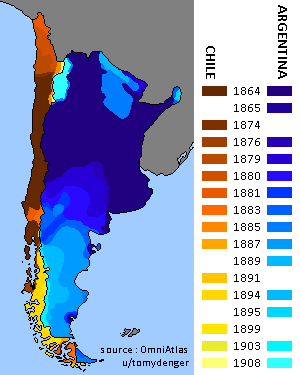
Territorial evolution of Argentina and Chile, showcasing the year of each land acquisition
Starting from the center of Ascension Island, which countries' coastlines can you reach in a straight line?

Starting from the center of Ascension Island, which countries' coastlines can you reach in a straight line? - Lemmy.World
[https://lemmy.world/pictrs/image/71a516e9-fecf-48e7-9d53-0ba7af9d0c78.png] [https://lemmy.world/pictrs/image/73f9379b-562d-47b4-b2db-40029a322bed.png] I made this in 2022 in QGIS (but when I uploaded it on Reddit back then, you may find it as starting at Ste-Helena island… don’t ask me why, I don’t remember how I made that mistake when posting it)
I used to makes a lot of maps like this or using a GIS of variable quality, interest and end result.
Also, I didn’t check if I made some spelling / grammatical mistakes back then on this one, but since the word count is low it should be fine, even if I messed up with fewer.
The Greatest extent of the Omani Empire

Depuis quand les départements français possèdent leurs formes actuelles
