James Hammett🌪️

468 Followers
211 Following
733 Posts
I chase storms across the High Plains in a Subaru
🌩️ Site Reliability Engineer running wx.social
🌩️ Builder of #TurretCam
🌩️ Creator of #1 most viewed tornado video and many duds
LocationDenver, Colorado
Website (verified)https://jameshammett.com/
Here's a closeup of the fireball. I could actually hear the thunderous WHOOSH as it erupted in flame after appearing to be struck by a large piece of debris from the #tornado
#FediWx
June 15, 2023: As many were just going about their day, this #tornado formed and immediately began to carve an EF3 damage path through Perryton, TX. After impacting residential and downtown areas, the tornado collapsed a radio tower and exploded a fuel storage tank as I rushed to escape
#FediWx
From a 0% "marginal" day to a confirmed #supercell #tornado — sometimes the high plains over-deliver 🌪️
May 25, 2017 I caught this spinner in Yuma County, CO, on timelapse — Turretcam footage shows clear ground circulation (arrow) forming right on the inflow boundary. Full chase log link in 🧵
#FediWx
The day didn’t stop there: I got absolutely rocked by 70+ mph winds in Grainfield, KS, and managed to drive through a developing circulation in Oakley. Full chase log ⤵️
https://www.stormdig.com/storm-pictures/2017/228-may-25-2017
May 25, 2017 Tornado

Live storm chasing video and photography with James Hammett. Breaking severe weather with tornadoes, hail, and lightning.

Everyone remembers Wray, but for a few the magic started in Eckley. May 7, 2016 I blasted east, betting on a #supercell cluster erupting near the state border. Just as I arrived this scene unfolded — a ghostly #tornado touching down north of Eckley, #Colorado 🌪️ Full chase log link in 🧵
#FediWx
May 7, 2016 Tornadoes

Summary Cold-core/upslope/warm front setup over eastern Colorado to western Kansas. Initially set up east of my target of Lamar, CO in case a cell went up in western Kansas where I expected better conditions for tornadoes....

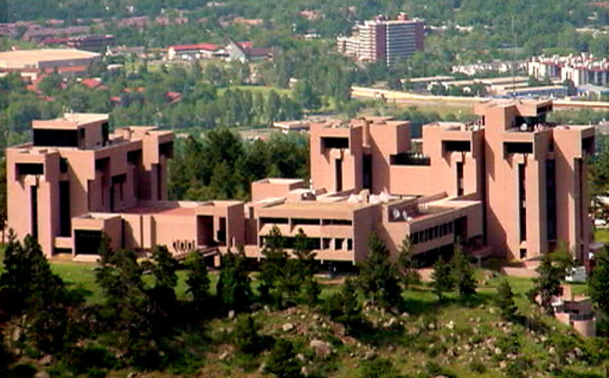
The US NSF has put out a "dear colleagues" letter that is essentially a yard sale list for the National Center for Atmospheric Research.

It asks questions such as, "who'd like to take over some of NCAR's programs?," and, "Is anyone interested in commercial use of the Mesa Lab?

If you have any thoughts about this that you'd like to share, you can send them to [email protected]

Here is the letter: https://www.nsf.gov/funding/information/dcl-nsf-intent-restructure-critical-weather-infrastructure

It's gonna be May 🌪️ in 71 days. Tornadoes will again be roaming the Plains.

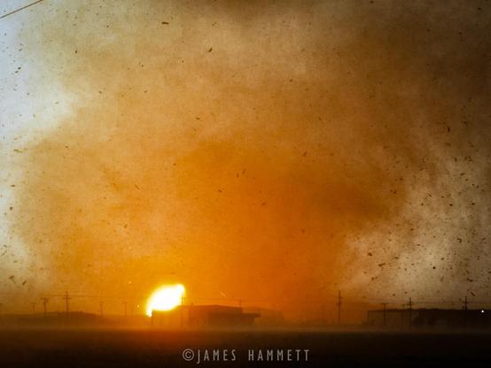
Flashback: May 17, 2019 I was chasing this monster #supercell near McCook #Nebraska. After a white-knuckle detour through a torrential rain core, I broke out just in time to intercept this EF-1 #tornado near Farnam.
#FediWx

The OsmAnd app (Android, iOS) uses offline data you save to the device in advance by simply selecting which states to download. I update mine at the start of each season and do smaller live updates on a per-chase basis. So it doesn't depend on internet access at all.
Other maps are happy to route you right into a plowed field with no distinction in road surface. But in OSM road surface is a metadata tag subject to crowdsourced editing! I've made a ton of edits myself and it feels like I'm actually accomplishing something on those completely busted storm chases.