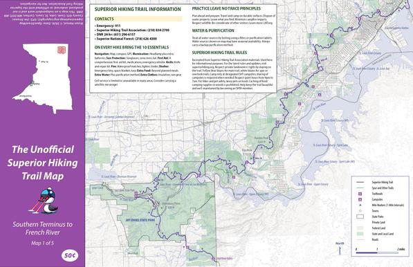
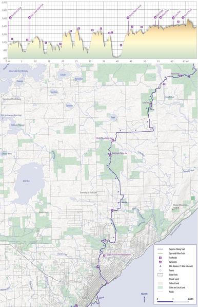
My Unofficial Superior Hiking Trail map is finished and available for free. This was a personal project that I wanted to do, and it resonated with a few hikers who asked me to make them available. This will likely be the only edition of this map, but it should be one of the most accurate produced. I aligned the entire SHT with Strava heat map data via Open Street Maps. That took many, many hours!

Get it here:
https://bryanhansel.lemonsqueezy.com/checkout/buy/16d0dbf5-dcd8-46c3-89ab-dc0667a54e37

#minnesota #backpacking #hiking

@bryanhansel That's awesome, thanks for doing it! I may try a through hike this year if I can't get my old body ready to do the collegiate loop in Colorado this summer with my son.
@bryanhansel Thats really cool. Thanks.
@bryanhansel
Did you incorporate this info back into OpenStreetMap?
@ianrbuck yes, the trail realignment via the Strava heat map data is now on OSM. I'm not sure if anyone has changed it after me. What I found is people were using their personal GPS units to track their hikes and then using that data (even if it was wrong) to update the trail. Last I checked, my work was still there, but that was a couple months ago.
@bryanhansel
Awesome, thank you for your service! 🫡
@ianrbuck you're welcome. I'm not sure it made a difference on my map at the scale I made it at. It only took about 20-30 hours.