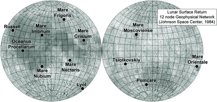
The Lunar Surface Return study also included a plan for a global geophysical network - seismology, heat flow etc. - with a 12-node network as mapped here. Most network designs are smaller than this, 4 nodes being a common arrangement. But I am getting ahead of myself here - this is 1984, but people were looking ahead to post-Apollo missions before anyone went to the Moon. Let's take a step back before we proceed.
#moon
While Apollo was being developed people were already looking ahead to a project called Apollo Applications Program. It would include a space station, a lunar base or outpost, long range rovers etc. A 1967 summer school at UC Santa Cruz explored the concepts:
https://ntrs.nasa.gov/api/citations/19670031235/downloads/19670031235.pdf
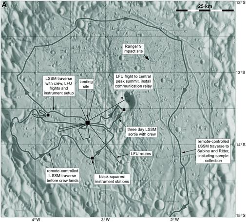
Here is a map of a mission to Alphonsus crater. LFU is a Lunar Flying Unit to get to places like the top of the central peak. LSSM was a rover (lunar scientific survey module).
#moon
Needless to say this went far beyond what Congress would be willing to fund. In the end only one part of the Apollo Applications Program was ever built, in a small way - Skylab, the first NASA space Station. But you think this was over the top? There are bigger things to come...
#moon
#moon
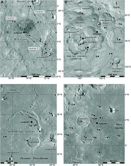
The Lunar Base Synthesis Study was done by North American Rockwell for NASA's Marshall Space Flight Center in 1971.
https://ntrs.nasa.gov/api/citations/19710016381/downloads/19710016381.pdf
https://ntrs.nasa.gov/api/citations/19710016382/downloads/19710016382.pdf
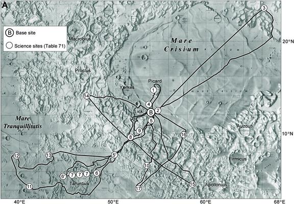
(there are other sections too). 7 large regions were identified, and in each a base site and potential traverses were shown on maps. It is covered in Part 4 of the Moon Chronicle. The scale of exploration and the cost would never have been feasible at the time - or even now. Here is an example.
#moon
In 1988 the Advanced Programs Office at the Johnson Space Center described a concept called Lunar Outpost. They found 4 sites: Lacus Veris in the Orientale basin, the south pole, the Apollo 17 landing site region and Mare Nubium. Astronauts would use rovers to explore long distances around the site. Another version of this called First Lunar Outpost would put a base in Mare Smythii, right on the limb at 90 east. It would service an observatory on the farside.
#moon
#moon

This outpost site at 90 east is just visible from Earth about half the time. However, librations (an apparent wobbling of the Moon caused by variations in its elliptical and tilted orbit) would hide this outpost site from Earth periodically. To remedy this a communication site 300 km further west would always be visible from Earth. The map also shows rover traverses out into cratered regions beyond the dark plains of Mare Smythii.
#moon
#moon
We have seen a few examples of possible future lunar exploration activities, some more feasible than others. There were more... check out the Moon Chronicle. But what was really needed was a new survey of interesting lunar sites, making use of the Apollo results. The mid-80s is too early for the new datasets like those of Lunar Prospector which began to reveal new locations of interest and surface compositions, so Apollo was the main source of ideas...
#moon
#moon
Mark Cintala chose some sites for a long rover traverse - seen a few days ago. Veteran USGS geologist and site selection specialist Don Wilhelms chose a number of sites, seen on this map, for future sample returns. These could be robotic or human missions, but either would give valuable results for understanding the Moon. It's odd to me that he didn't include Ina, the prototypical 'irregular mare patch' which was known to him.
#moon
#moon
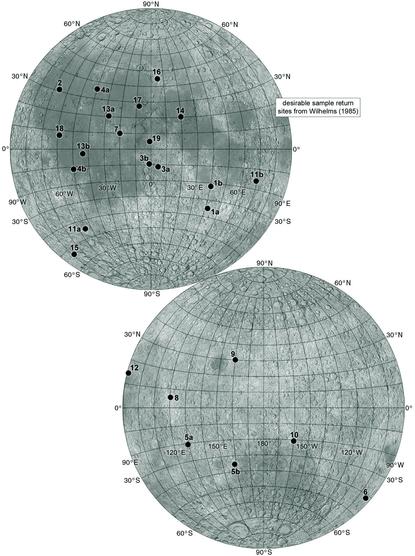
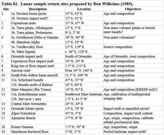
Here is a table of Wilhelms' sites giving a bit more information, straight from the Chronicle. Talking of Ina, we are starting to get suggestions for landing sites for Chinese astronauts and I fully expect that either Ina itself or a more equatorial example like the Maskelyne IMP could make the list as it develops. I will be covering this subject later in this set of posts.
#moon
#moon
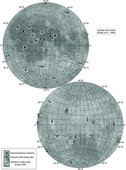
Graham Ryder of LPI put out a bigger list of sample return sites in 1989 (this one does have Ina in it, no. 46 on the map). The map shows reconnaissance sites for robotic landers a bit more capable than Luna 24, and intensive field study sites for either landed crews or sophisticated telerobotics. I won't post the 2 tables for these lists, but they are in Chronicle part 7. The point about these lists is that they form a foundation for later site studies.
#moon
#moon
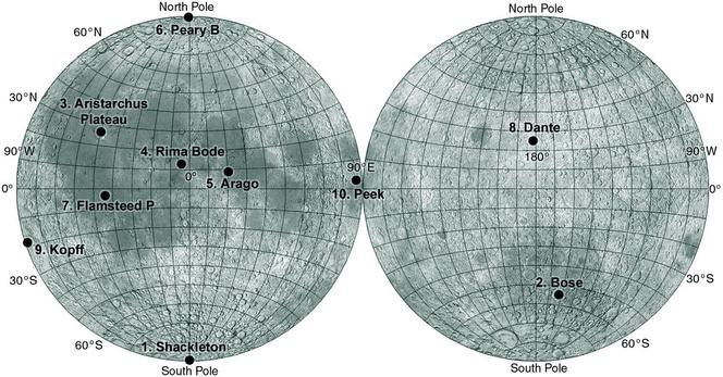
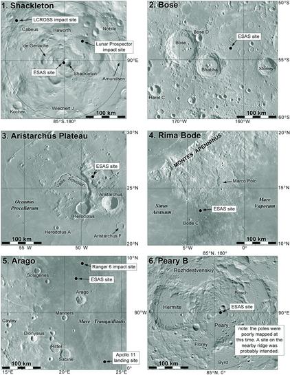
New ideas about lunar bases or outposts arose in the 1990s. JSC sponsored 2 workshops in mid-1990 about 'A Site Selection Strategy for a Lunar Outpost'. It came up with 6 sites for an outpost. This illustration shows the six sites (plus another at the north pole from a different source) and 2 of them shown in more detail. Various science targets were identified around each base or outpost (they are listed in the Chronicle).
#moon
#moon
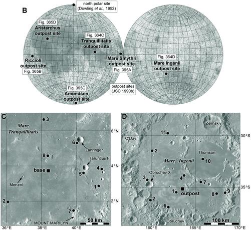
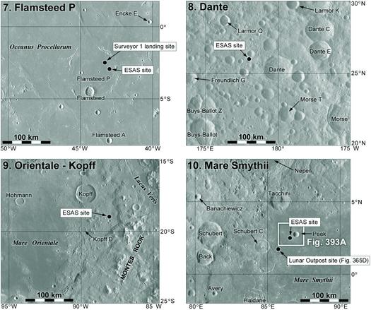
Here are the other 4 outpost sites from the 1990 study. One of them in Riccioli crater has some rover traverse routes mapped. All of them have science targets around them. This is all pre-LRO and does not identify sites we might look at now. For instance the previous post showed Mare Tranquillitatis and Mare Ingenii, both of which contain skylights (collapsed portions of roofed-over lava tubes) giving access to caves, a hot topic today but unknown in 1990.
#moon
#moon
In 1989 President George H. W. Bush proposed a long range plan for NASA which became the Space Exploration Initiative, involving the Sopace Sration, a return to the Moon ('this time, back to stay') and then to Mars. Its cost was excessive and it faded away quite quickly. The next President Bush had his own proposal in 2004 which was known as the Vision for Space Exploration. It had the same basic goals and this time it survived long enough for quite a bit of planning...
#moon
#moon
One of the early products of the Vision was a NASA report:
NASA 2005. NASA’s exploration systems architecture study, final report. NASA-TM-2005-214062, November
2005.
http://large.stanford.edu/courses/2012/ph241/copeland1/docs/140649main_ESAS_full.pdf
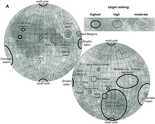
The Exploration Systems Architecture Study (ESAS) identified ten sites as potential exploration targets, as shown in this map. You might suppose that this would be the result of long and careful consideration. Not really.
#moon
Paul Spudis, who put the list of sites together, told me that it came from the big lists of Don Wilhelms and Graham Ryder, plus the six Lunar Outpost sites already discussed. From them, these 10 ESAS sites were chosen so provide a global distribution and to sample a variety of terrain types and interesting sites. This was done quickly to get something ready for the report, and later studies soon added other sites. We will look at some of them next.
Here is a bit more detail on the ESAS lunar exploration sites. Today the emphasis is on the south pole, but ESAS suggested a series of landings in other places. We call missions like that 'sorties'. Apollo was all sorties, but they did, early on, consider a fixed base instead, though not at the pole. Vision planning was a mix of sorties and a south polar base or outpost. Here are 6 sortie sites. No. 4, Bode, has been suggested for a Chinese crewed landing.
#moon
#moon
Here are the remaining 4 ESAS sites. I am a bit puzzled by the Aristarchus site shown in he previous post. It's on top of a highland block without easy access to Aristarchus crater or Schroter's Valley, two major features of interest. The reason for that specific place eludes me. Most places shown in the literature for a landing here put it down below the highland where pyroclastics, young crater ejecta and young mare basalts are easy to reach.
#moon
#moon
ESAS also thought about a fixed outpost site where infrastructure would be built up over many landings - like what we now call Artemis Base Camp. The Lunar Architecture Team in 2006 proposed a site on the rim of Shackleton crater at the south pole:
https://www.lpi.usra.edu/lunar/strategies/NASALunarArchitecture/dale_12_06.pdf
Here is their initial proposal for an outpost layout from that presentation. This is before LRO. The poles were poorly mapped and you can see here the pole was mislocated by about 3.5 km.
#moon
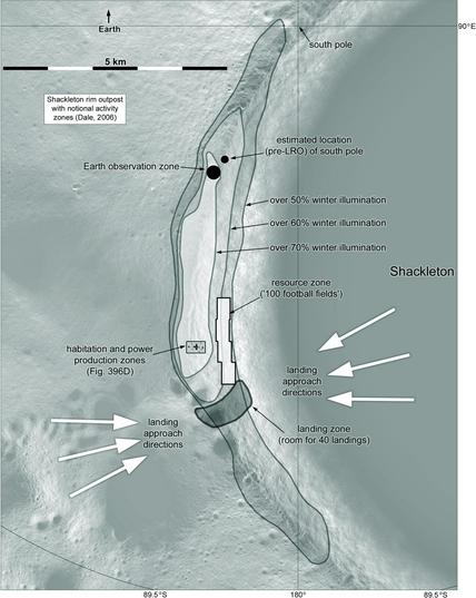
The location of the pole is only part of the problem. The actual strip of ground with prolonged illumination is very narrow, not at all as shown here. Take the landing zone: half of it is actually on the inner wall of Shackleton, far too steep to allow a landing. The other half, by bad luck, is mostly occupied by a crater not seen in older data. The resources (ice) would probably be sought elsewhere, not along the sunlit upper slope of the crater wall. But it's a start.
#moon
#moon
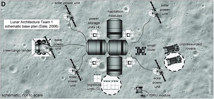
The habitation and power site on the previous map is enlarged here - taken from the same presentation I linked to yesterday. Sadly, the author forgot to note how many football fields it covered so it's not to scale. I have placed it on an arbitrary bit of Moon in the approximate location of the outpost. Habitats, solar power plants, rovers etc. would be built up over a period of a decade or so.
#moon
#moon
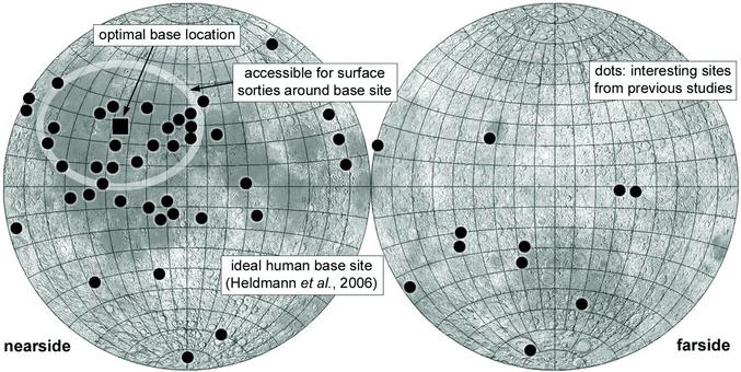
What if you didn't want to go to the pole? Jennifer Heldmann of NASA Ames mapped the various sites suggested by RYder and Wilhelms and identified a site which would give access to the most targets of interest. That puts it near Prinz crater in Mare Imbrium, as shown here. Others have suggested the Aristarchus Plateau not far from there for its possible in situ resource potential. Next I will look at a few more rover traverse suggesdtions.
#moon
#moon
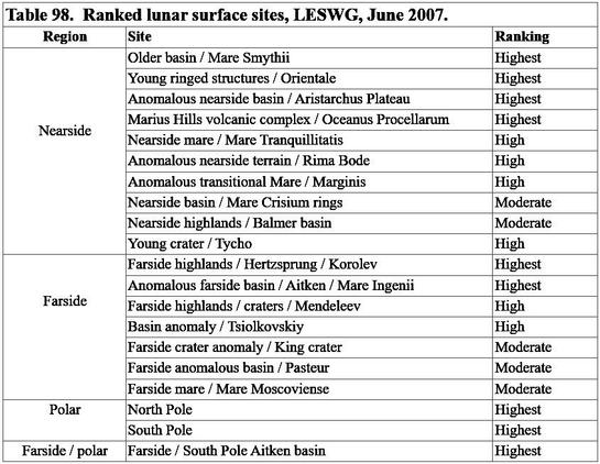
Oops, before we get to more traverses, here is another set of global targets - we have this tension between a polar outpost and sorties to many sites. Pamela Clark (then of Goddard, now at Morehead) presented a list of ranked targets to the 8th meeting of the Lunar Exploration Science Working Group on 28 June 2007. The Vision for Space Exploration didn't get beyond this problem. Here is a map.
#moon
#moon
And here is a table summarizing those targets. This is from my Chronicle, section 8, which is still in progress.
#moon
#moon
I posted a map of 10 ESAS sites earlier. They were only examples of potential sites of interest but the map was often taken as definitive. Here are two suggestions from 2007 on how they might fit into a long-term plan:
https://www.lpi.usra.edu/meetings/leag2007/presentations/20071004.wilcox.pdf
- near the end. The first idea is the use of a mobile habitat plus other equipment (power etc). It's pre-landed at one ESAS site, used by a crew, and then spends a year or so driving to the next, operated from Earth.
#moon
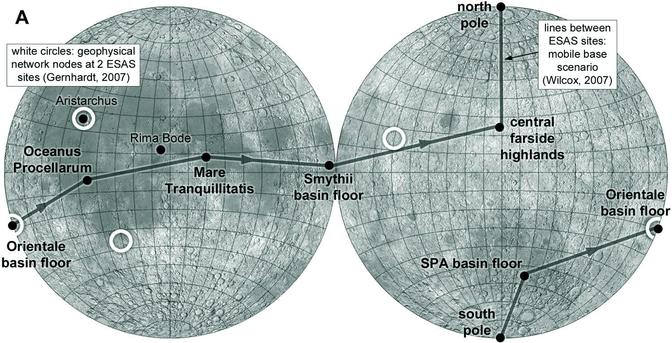
The map of the route in that presentation is a horrible sketch but I have made it more realistic. Another map earlier in the presentation shows 4 geophysical network nodes (Mike Gernhardt described them in more detail elsewhere). They form a typical network pattern, 3 nodes around a strong seismic source found by Apollo, plus one at its antipode so signals pass through the lunar core. 2 are at ESAS sites, the other 2 are new locations.
#moon
#moon
Back to the south pole. An example of a 900 km, 7 day sortie from the polar outpost was described by Mike Gernhardt in 2007. 4 crew would travel in two pressurized rovers, in cabins lined with ice for radiation protection and thermal control. In the event of a rover failure, all 4 could travel back in the other rover. 6 sites would be examined during 3.25 hour EVAs, three per rover, in pairs close together in areas shown here.
#moon
#moon
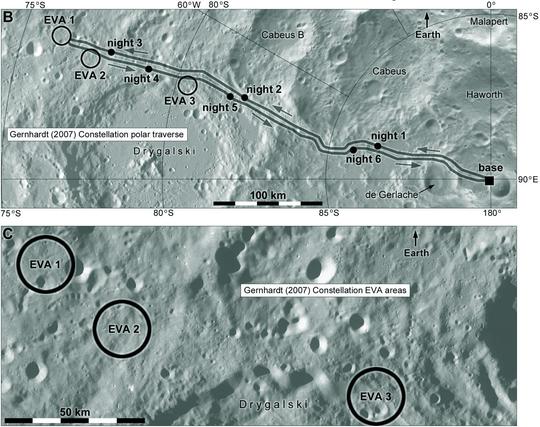
The sortie proponents had lots of great sites to visit - Marius Hills, Aristarchus, Bode, Orientale... In comparison the south pole looked very bland except for the possibility of ice and other frozen goodies. Those EVA sites seem rather arbitrary, not very special. The map uses the name Constellation, which I forgot to mention earlier. It was NASA's program to achieve the goals of the Vision for Space Exploration laid out by the President.
#moon
#moon
There were many presentations at meetings during 2008 about possible sortie missions for the Constellation program. We will look at a few before we say goodbye to this round of studies. Here are several by Pam Clark, who was very busy on plans like this at the time. These are all on the farside in the giant South Pole-Aitken basin, which was finally starting to be understood. Clementine showed it clearly for the first time in its global topography data in 1994.
#moon
#moon
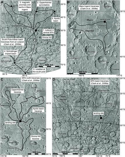
Clark mapped very long traverses, up to thousands of km long. One map includes an outpost site near Bose crater. The third map indicates 'Olivine Hill', shown in orbital data to have an unusual composition. It might include material from below the lunar crust, excavated by the massive impact which formed the basin or erupted as lava (it looks a bit like a volcanic plateau). It has been of interest ever since, and is currently given the informal name Mons Marguerite.
#moon
#moon
These sites were not all on the far side. Here are some more from Pam Clark. We have one at the south pole - part of the last set, really - but the main set of traverses here is in Oceanus Procellarum. At lower left is a modifiedl detail from the larger one showing part of a route around the Aristarchus Plateau. Other long drives visit points of scientific interest, and this is a very target-rich region of the Moon.

A final pair of non-polar sortie scenarios from the Constellation period - there were lots of others. These were presented by Laurie Leshin (Goddard) and Gordon Johnston (NASA) at a Planetary Science Subcommittee meeting in October 2008. The top map shows multiple traverses on the floor of Tsiolkovskiy crater on the farside. The lower map shows Alphonsus on the nearside. The latter set were done in pairs by 2 teams with a chance of help if problems arose.
#moon
#moon
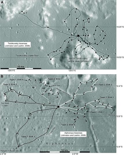
The Alphonsus map shows a visit to the impact site of Ranger 9. We have never had a human or robotic visit to a spacecraft impact site like that, though the idea has been suggested before. An impactor might be used to expose fresh material from a shallow depth for analysis. I would like to see one of the Apollo Lunar Module ascent stage impact sites, which look very unusual in LRO images, long troughs cut into the surface by an oblique impact rather than circular craters.
#moon
#moon
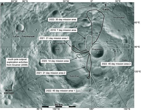
John Gruener of JSC presented details of planning by the Constellation Architecture Team-Lunar at the LEAG meeting in 2008. Would NASA build an outpost or do sorties to different places? A bit of both. Each year 2 or 3 flights with crew and cargo would add to the outpost and allow progressively longer surface stays. In addition, sorties would be flown to unspecified locations every 2 years or so. Long surface traverses from the outpost would explore the region bit by bit, as we will see.
#moon
#moon
Here is a map of Gruener's thoughts about surface exploration around the pole. This is much less ambitious than the 1000 km plus routes we have been looking at, but still a lot more than I can imagine from Artemis in the next decade or two. Look at the timeline here - first excursion in 2019, going up to 2022. The plan extended up to 2026 but would continue beyond that.
Remember all this planning preceded LRO, but as it approached launch some new ideas arose - see them tomorrow!
#moon
LRO, the Lunar Reconnaissance Orbiter, was designed specifically to help choose and characterize Constellation landing sites in its first year of operation, before being passed to the science side of NASA where it has been ever since. But which sites would it look at in that year? The Constellation Program Office combined the lists we have already looked at and sifted them to produce a list of 50 sites (and soon added a few more). This little map shows their locations.
#moon
#moon

For each site they produced a map showing square areas 10, 20 and 40 km across around the target of interest. The middle square got the best data coverage (full stereo imaging) and the surrounding areas got the best coverage thy could manage in the time. LRO went on to image the entire Moon under multiple lighting angles (though not all in stereo) but expectations were lower at first. Here is a typical set of these target maps (the full set is in Moon Chronicle part 8).
#moon
#moon

Naturally after this, much of the planning focused on those sites. Strictly speaking these were for planning purposes, exploring surface slopes and roughness etc. for a wide range of terrain types to help plan landers and rovers. But inevitably they were also regarded as semi-official landing targets. Eventually LRO vastly outperformed expectations and in the new global data many new targets were found as well. You might suppose that Constellation had a rosy future... but no.
#moon
#moon
LRO launched in June 2008. 8 months later, bowing to economic reality, President Obama called an end to Constellation. The plans I have illustrated came to nothing at the time. But they form a foundation from which new plans can grow, and indeed we are now in a new phase of mission planning. Events in just the last week are enough to give the most seasoned observer whiplash... but they don't really change the landing site planning I will look at next. We will start with Artemis tomorrow.
On to Artemis. Constellation planning didn't end where I stopped it here - studies already done go on to be written up for a while afterwards. Other studies continue - it's a full time job just trying to keep up. Eventually they become studies for the new program. From the beginning Artemis had as its main focus the south pole, so here are some sites from the Artemis Science Definition Team 'townhall' in October 2020. A mix of high illumination and access to volatiles sites.
#moon
#moon
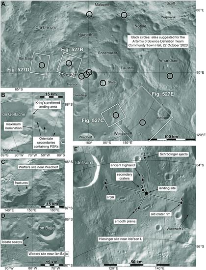
The arguments for polar sites are well known, but to summarize - a few very small points on hills and ridges offer prolonged illumination, breaking the tyranny of the 2-week lunar night to some extent. There are no 'peaks of eternal light' but there are places where sunlight is available uninterrupted for several months at a time. Nearby, crater floors which never see the sun may trap and preserve volatiles like water, carbon dioxide and other substances, a possible resource.
#moon
#moon
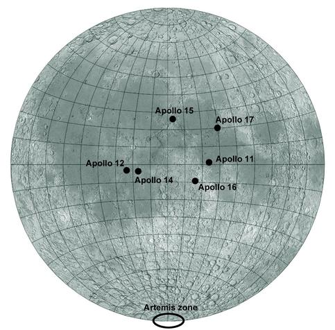
I want to emphasize just how different Artemis will be compared with Apollo. This map shows the Apollo sites, and it is surprising to some that Apollo sites span such a small area of the Moon. That's partly because maps of the sites often use an orthographic map projection which exaggerates the middle of the disk and foreshortens (and so shrinks) the edges. This is an equidistant (nearly but not quite equal area) projection which shows the situation more realistically.
#moon
#moon
Here is a nice view of the south pole - a map of illumination conditions draped over topography. There is some vertical exaggeration but I don't have a number for it. Dark areas get very little or no sunlight at all. Bright patches - mostly very small strips on peaks and crater rims - get a lot of light, as much as about 75-80% of a lunar day in a very few places. The relief here exceeds Mt. Everest in height. Not your grandad's Moon (I speak as a grandad).
#moon
#moon