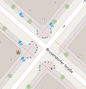
Such landuse micro-tracing around all driveways etc seems excessive, but then at least somebody is tracing them :)
Such landuse micro-tracing around all driveways etc seems excessive, but then at least somebody is tracing them :)
@richlv I wouldn't define this as excessive tbh. Of course some added really nice sprinkles here :+1:
But have a look here:
https://www.openstreetmap.org/#map=18/52.475457/13.451346&layers=N
Even the street/way areas are defined. kerb, not only on the junction of a road and a way, it is also defined on the entire length. Trees, every single parking slot and so on... 🤯 😂