RE: https://kolektiva.social/@DoomsdaysCW/115163665564095883
A model for #SustainableCommunities everywhere!
RE: https://kolektiva.social/@DoomsdaysCW/115163665564095883
A model for #SustainableCommunities everywhere!
@DoomsdaysCW that's really cool!
I would love to live in a place like that.
There is a photographer (#AlexDeSteiguer) who lives on the island in the winter. Some days, I really want her job! @knowprose
SOME days. The other days are why our settler ancestors whom the ocean hadn't yet killed moved to the mainland.
@DoomsdaysCW @n1vux wow.
Society is weird. But I guess it's not for everyone for obvious reasons.
But give me that, some paper and a good supply of pens, and shelves full of books...
I would consider that a good life. Active in mind and body.
I didn't like winters in a lot of places because of that entrainment to a productivity tempo I didn't set. I could have set my own there.
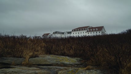
So, here's a link to an archived version of the website (the original is not secure), which talks about the installation on Appledore, @n1vux . It was a "Base-End Station"
" Built in April of 1944, the Appledore Island Base-End Station (location 141 site 1A) was a seven story square reinforced concrete building that stood over fifty feet tall. The fifth story was used for Battery Barry at Fort Dearborn (station designation B3/1 S3/1), the sixth story was going to be used for Battery Curtis at Fort Foster (station designation B2/6 S2/6), the seventh story was used for Battery Seaman at Fort Dearborn (station designation B7/2 S7/2) and the roof was used for anti aircraft purposes (station designation AAIS OP 6). The 7th story also had a depression rangefinder and the roof had a SCR-296A fire-control radar. The tower still exists but is on private property and there is no public admittance. Also built on Appledore Island were Army barracks (location 141 site 1B), a Navy Magnetic Indicator Loop Station, two searchlights (positions 6 and 7) and, built in 1943, an Army Crib Wharf and Pier. Magnetic Loop Indicators were cables laid on the ocean floor to detect submarines passing. The cables were laid from Sisters Point, Kittery, Maine, to Appledore Island, Kittery, Maine to Rye Ledge, Rye, NH. The Crib Wharf and Pier was destroyed in 1947 in a storm. No other buildings still exist. Tours of Appledore Island are available through UNH Marine Docents. Tour information is available on their site."
(My wife probably knew that.
When we attended old NecronomiCon, late last century, I was the +1. I'm only HPL-adjacent ... )
@DoomsdaysCW @n1vux well, people were products of the societies they lived in.
To survive as any type of minority required a public mask above reproach.
It's not an excuse. It's simply how people survived. The same happens even now. Virtue signaling. Tribal calibration. Etc.
Safe spaces for many are what they build, not what they have.
(I am *not* making a Haverhill joke. Haverhill was once a out-parish of Rowley, and as such, I shouldn't speak ill of land of my fathers. But the temptation.)
One of the many Goudsward books I own, @n1vux .