LOCATION DETAILS… but whose map?
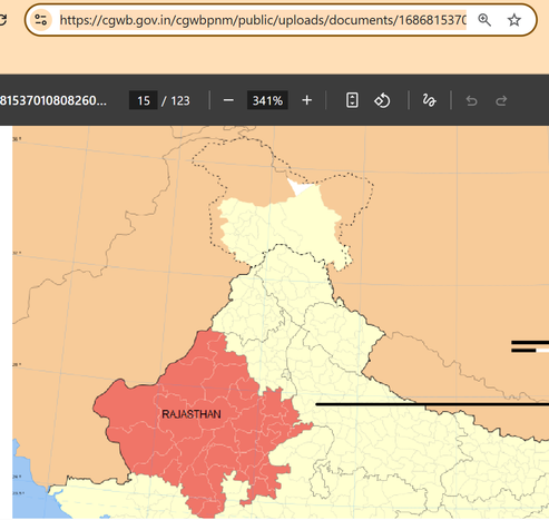
On the Central Ground Water Board (CGWB) @CGWB_CHQ website, a map used for a Ramgarh aquifer study colors Pakistan-occupied Kashmir in the same shade as foreign territory.
That is not a trivial cartographic choice.
LOCATION DETAILS… but whose map?
On the Central Ground Water Board (CGWB) @CGWB_CHQ website, a map used for a Ramgarh aquifer study colors Pakistan-occupied Kashmir in the same shade as foreign territory.
That is not a trivial cartographic choice.
Government of India policy is clear: the entire former princely state of Jammu & Kashmir - including areas under Pakistan and China control - is part of India’s official map depiction. The Line of Control may be shown, but the territory itself is not to be rendered as foreign sovereign land.
Yet here, the color scheme visually treats PoK as outside India.
Is this an imported GIS base layer?
A careless template?
Or simply no cartographic scrutiny before publication?
Maps are not neutral graphics. They are statements of sovereignty.
If a central government website cannot get India’s own map right, what exactly are we normalizing? @CGWB_CHQ
https://cgwb.gov.in/cgwbpnm/public/uploads/documents/16868153701080826040file.pdf