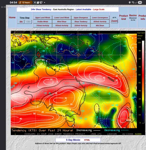
So Tropical Cyclone Fina has been named and is now Category 1 intensity, the system became category 1 earlier than expected for the reasons I said were holding it back yesterday, so yesterday there were unfavourable windshear over the system, in the last 24hrs the shear has dropped leaving the system with a big buffer of favourable and neutral windshear conditions, with a shear tendency of -10 to -20 kts in the past 24hrs in the vacinity of TC Fina, also attatched are ensemble runs of the GFS and GEPS for TC Fina, taking both the GFS Ensemble and GEPS into account I think for now a lot of the potential tracks that keep it far offshore in tte Arafura and Timor Sea are less likely and ttat the system will likely remain closer to the coast, there is one outlier on GEPS that shows a Gulf landfall at 970-980hPa which would likely be around Category 3 Severe Tropical Cyclone, and its not the only track that landfalls at pressures that would suggest around Category 3 intensity, all of those tracks though sit at beyond the 72 hours mark which I give less weight to - Nightmare Typhie
#TropicalStorms #Hurricanes #Typhoons #TropicalCyclones #Cyclones #ActiveTropicalCylones #CurrentTropicalCyclones #ActiveTropicalStorms #CurrentTropicalStorms
#TropicalStorms #Hurricanes #Typhoons #TropicalCyclones #Cyclones #ActiveTropicalCylones #CurrentTropicalCyclones #ActiveTropicalStorms #CurrentTropicalStorms


