🔥 New Paper Alert 🔥 -- from the incomparable @ioes.ucla.edu Senior Practicum in Environmental Science with the paper led by new alums Sammy Fruman and Bethany Woo --> anonymized smartphone data show park use in extreme heat 1/ #heat #hazards #mobility #cities www.sciencedirect.com/science/arti...

Smartphone location data show ...
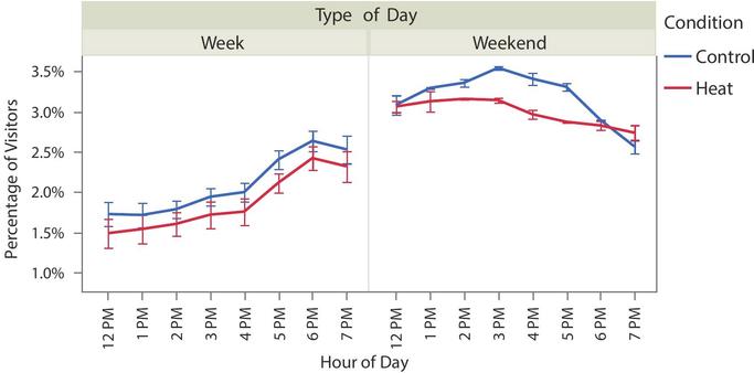
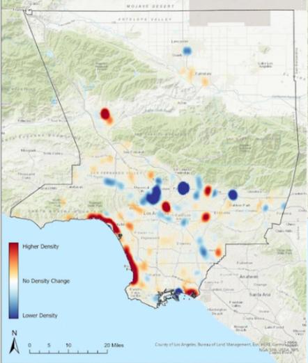
Parks are used slightly less during extreme heat days than paired control days. Parks are good to reduce temperatures, but to alleviate heat in events but are used less when it is hot. Except the beach. People go to the beach in LA when it is very hot. 🏖️☀️🏄‍♀️ 2/
Time of day and day of week are more important to park use than weather. But people do stay later in the evening at parks when it is super hot. 3/
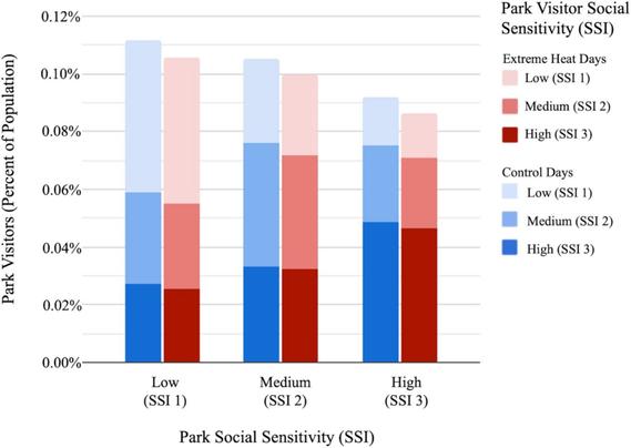
People from socially vulnerable areas are more likely to visit parks in less vulnerable areas than vice versa. The higher quality parks in more wealthy areas are visited by people curating their environments through mobility. 🚋 🚗🚲 4/
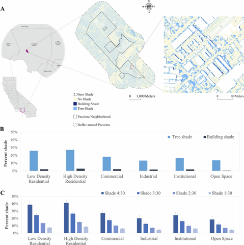
Planners should focus shade for cooling in areas of greater convenience (i.e. along daily routes) during extreme heat. Invest in cooling centers, streetscapes, workplaces, and residential comfort. 🌳🌳🌳🌳🌳🌳🌳 4/
This is part of our series of papers using 📱 smartphone data to understand extreme heat impacts in Los Angeles. See: Smartphone locations reveal patterns of cooling center use as a heat mitigation strategy 🧊 www.sciencedirect.com/science/arti... 5/

Smartphone locations reveal pa...
And: Space-time dynamics in hazard exposure analysis: smartphone locations show pedestrian routes are inflexible to extreme heat events. www.nature.com/articles/s44... 6/

Space-time dynamics in hazard ...
Space-time dynamics in hazard exposure analysis: smartphone locations show pedestrian routes are inflexible to extreme heat events - npj Natural Hazards

Vulnerability to environmental hazards is spatially heterogeneous and dynamic. Static measures that are used to determine spatial heterogeneity in vulnerability are unable to capture temporal dynamics. To complement research on vulnerability to extreme heat, we investigated temporal and spatial trends in availability and use of shade by pedestrians during extreme heat events in a vulnerable neighborhood. Shade from trees and buildings calculated from LiDAR were paired with smartphone locations filtered to include outdoor pedestrians on an hourly basis for control and extreme heat days to study behavioral patterns for neighborhood residents, non-residents, and the unhoused population. High-use pedestrian locations showed little difference in activity between control and extreme heat days, especially during weekdays, but with greater variation on weekends. The results indicate inflexibility in space use, even during extreme heat. Outdoor heat mitigation strategies should consider bringing shade to the people in heavily used locations, as pedestrian behavior is inelastic.

Nature
Put these papers together and when it comes to _outdoor_ exposure to extreme heat, you need to bring shade to the people where they are -- bus stops, parking lots, dropoff/pickup locations -- and similarly provide cooling locations close to where they are (minimize walking to get there). 7/
Big thanks to @uclasustainablela.bsky.social at for funding the Heat Resilient LA project and @countyofla.bsky.social for their collaboration. end/