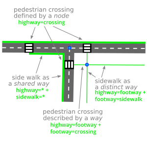
Mapping the surface of pedestrian crossing

https://lemmy.world/post/30383171

In that instance I would go for either three or four. The paths either side of the crossing are paving stones, and the crossing itself is asphalt.

I’m not sure what the guidelines are, but I’d lean towards marking the paths as sidewalks. They’re not separate areas, they’re part of the sidewalk, but crossing the road.

I’d say 2, 3 and 4 can make sense depending on which one reflects more accurately the reality on the ground. The problem is that different mappers will answer differently if you ask them “is this part of the sidewalk or is this a path connecting sidewalk and street?”. I don’t think there is a clean cut answer to your question, but wait for others to chime in.

3 is my preferred method for a couple reasons:

Splitting the crossing way into 3 parts let’s you mark the node at the kerb as kerb=*

To me it makes most sense to mark the stubs on either end of a crossing as matching the sidewalk or footpath itself as long as that stub isn’t significant enough to be it’s own path with unique properties.

I, too, would use 3 as the stub before the kerb isn’t actually crossing the road (e.g. one could walk to kerb, turn around, and go back without stepping a foot into the road proper). Similar to mapping the pedestrian refuge portion of a footway between carriage ways as footway=traffic_island instead of footway=crossing.
Splitting is a necessity if you want to add barrier=kerb. I use No.4 since I think it’s the most accurate