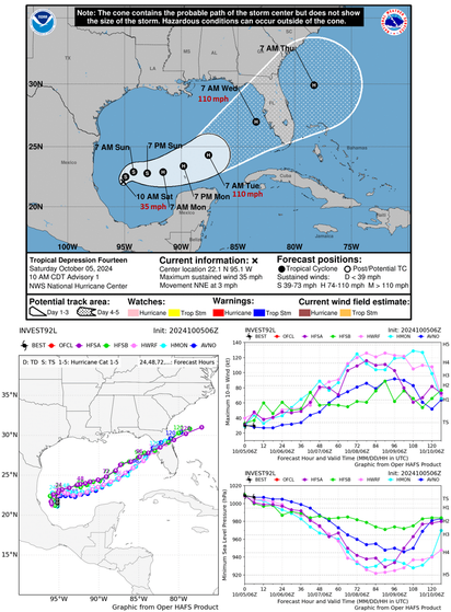
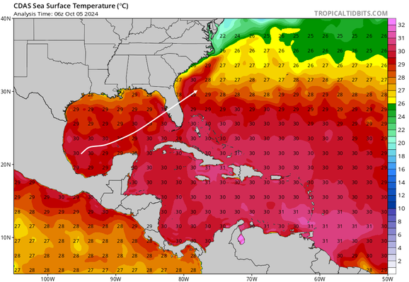
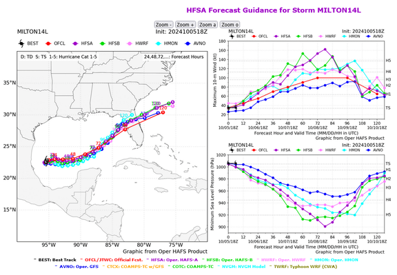
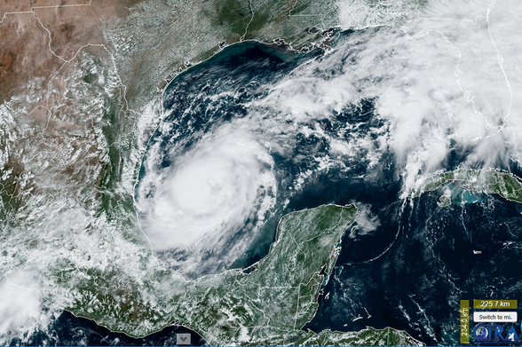
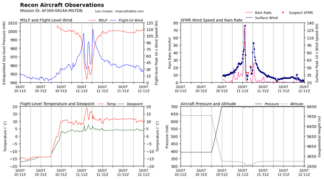
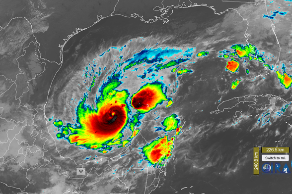
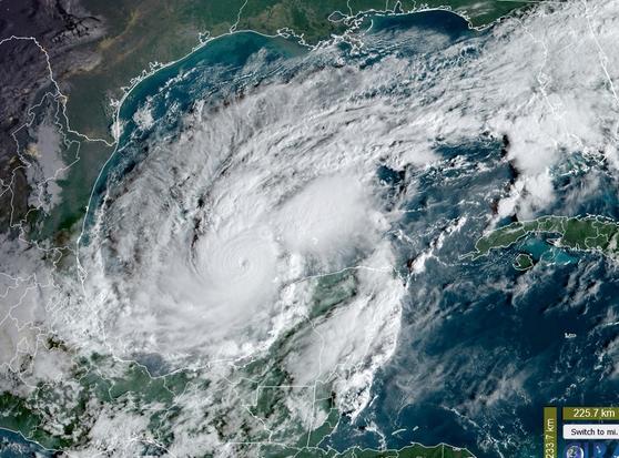
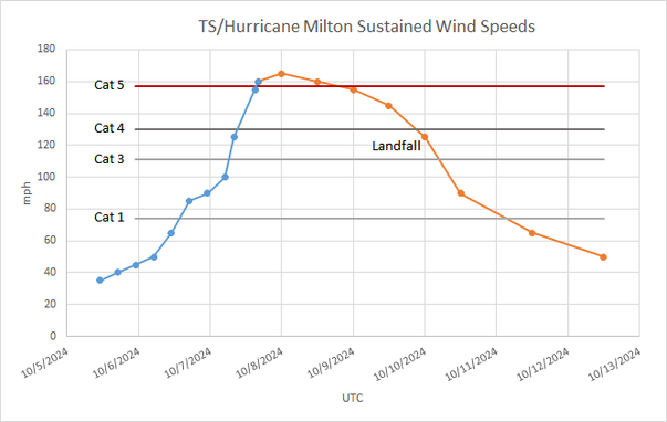
Storm INVEST92L (aka Tropical Depression 14, to be named Hurricane Milton) is threatening to become a Cat 4 hurricane and slice thru Florida next week.

Some models indicate even higher wind speeds than the conservative values forecast by NHC.

Biden govt and FEMA will be busy making plans and preparations, republicans will be busy creating disinformation and accusations. We need to prepare to neutralize their disinformation campaign.

https://www.nhc.noaa.gov/
https://www.emc.ncep.noaa.gov/hurricane/HFSA/tcall.php
1/n

National Hurricane Center

As is the new normal, Climate Change induced high heat content in the Gulf waters will facilitate rapid intensification and higher moisture content over the next few days of Storm INVEST92L (aka Tropical Depression 14, to be named Hurricane Milton).

The map below shows Sea Surface Temperatures in the Gulf of Mexico and in the path of the storm.

https://www.tropicaltidbits.com/analysis/ocean/
2/n

Ocean Analysis | Tropical Tidbits

Analysis tools for tracking and forecasting tropical weather

Tropical Tidbits

Tropical Storm Milton is swirling in the Gulf of Mexico with winds at 45 mph. But the forecast for wind speeds before landfall in Florida on Wednesday has risen considerably, with some models predicting winds of 184 mph, far above Cat 5.

Please make preparations and stay informed using reliable sources.

https://www.emc.ncep.noaa.gov/hurricane/HFSA/tcall.php
https://www.nhc.noaa.gov/
3/n

Hurricane Analysis and Forecast System

Milton now has attained Hurricane status with wind speeds of 80 mph.

Current forecast for wind speeds before landfall is 125 mph, which will likely be revised upwards. The track forecast has not changed much.

"Given the track over the very deep warm waters of the Gulf of Mexico and little shear for the next couple of days, rapid intensification is explicitly forecast, and the new NHC prediction could still be conservative ..."

https://www.nhc.noaa.gov/
https://rammb-slider.cira.colostate.edu/?sat=goes-16&sec=full_disk&x=6872&y=5884&z=3&angle=0&im=12&ts=1&st=0&et=0&speed=130&motion=loop&maps%5Bborders%5D=white&p%5B0%5D=geocolor&opacity%5B0%5D=1&pause=20241006161020&slider=-1&hide_controls=0&mouse_draw=0&follow_feature=0&follow_hide=0&s=rammb-slider&draw_color=FFD700&draw_width=6
4/n

National Hurricane Center

The NASA Europa Clipper mission launch, scheduled for Thu, Oct 10, around 12:31 p.m. EDT, will probably get postponed as Hurricane Milton passes over the Kennedy Space Center area Wednesday evening.
5/n

Hurricane Milton has further intensified during the day today. Current wind speeds are at 85 mph. Forecasted wind speeds before landfall are now at 145 mph (Cat 4). The track forecast has not changed much.

"The NHC forecast is raised from the previous one and lies near the intensity consensus model and still could be too low. Later on, vertical wind shear is forecast to markedly increase as Milton approaches FL and some weakening is anticipated (before landfall)."

https://www.nhc.noaa.gov/
6/n

National Hurricane Center

As expected, NASA is standing down from the Thursday, Oct. 10, launch attempt of the Europa Clipper mission due to Hurricane Milton.

“The safety of launch team personnel is our highest priority, and all precautions will be taken to protect the Europa Clipper spacecraft,” said Tim Dunn, senior launch director at NASA’s Launch Services Program.

There are additional launch opportunities until Wednesday, Nov. 6.

https://blogs.nasa.gov/europaclipper/
7/n

NASA's Europa Clipper Mission

Hurricane Milton has strengthened considerably overnight. Current wind speeds are at 125 mph. The forecast calls for a peak wind speed of 155 mph in 24 hours.

The Air Force aircraft very recently reported a peak flight-level wind of 120 kt, and dropsonde data show that the pressure has fallen to around 945 mb.

The top-right graph below shows peak surface level wind speed above 130 kt (150 mph)!

https://www.nhc.noaa.gov/
https://www.tropicaltidbits.com/recon/
8/n

National Hurricane Center

Hurricane Milton is taking on the familiar ominous well-rounded shape with a distinct eye.

The track has shifted southward a bit. Some weakening is expected in the 24 hours before landfall because of wind shear. Let's root for more wind shear.

https://rammb-slider.cira.colostate.edu/?sat=goes-16&sec=full_disk&x=6952&y=5456&z=3&angle=0&im=12&ts=1&st=0&et=0&speed=130&motion=loop&maps%5Bborders%5D=white&p%5B0%5D=band_13&opacity%5B0%5D=1&pause=20241007115020&slider=-1&hide_controls=0&mouse_draw=0&follow_feature=0&follow_hide=0&s=rammb-slider&draw_color=FFD700&draw_width=6
9/n

RAMMB/CIRA SLIDER: Satellite Loop Interactive Data Explorer in Real-time with GOES-16 and Himawari-8 Satellite Imagery

The 9 am ET update from NHC has upgraded Hurricane Milton current wind speeds to 150 mph (Cat 4) 😲

"Data from both Hurricane Hunter aircraft indicate that Milton has strengthened to a category 4 hurricane. The maximum sustained winds are estimated to be 150 mph (240 km/h).
Milton is a category 4 hurricane on the Saffir-Simpson Hurricane Wind Scale.
Data from the aircraft also indicate that the minimum pressure has fallen to 940 mb"

https://www.nhc.noaa.gov/
https://rammb-slider.cira.colostate.edu/?sat=goes-16&sec=full_disk&x=6864&y=5904&z=3&angle=0&im=12&ts=1&st=0&et=0&speed=130&motion=loop&maps%5Bborders%5D=white&p%5B0%5D=geocolor&opacity%5B0%5D=1&pause=20241007133020&slider=-1&hide_controls=0&mouse_draw=0&follow_feature=0&follow_hide=0&s=rammb-slider&draw_color=FFD700&draw_width=6
10/n
#Milton

National Hurricane Center

Hurricane Milton went from Tropical Storm to Cat 5 in a little over 24 hours!

The NHC and NOAA predictions were close. As the science-based community understands, predictions are not based on amateur observations or personal expertise, they are based on weather models, equations, measurements and software developed by weather and climate scientists over decades. The NHC forecasts are based on averages across several models and tend to be conservative.

Data source: https://www.nhc.noaa.gov/
11/n

National Hurricane Center

AF309 Hurricane-Hunter aircraft has measured surface winds of Hurricane Milton twice at values near 180 kt (207 mph) 😲

Milton is forecast to weaken to about 125 mph before landfall due to wind shear and dry air.
🙏
https://www.tropicaltidbits.com/recon/
12/n

Aircraft Reconnaissance | Tropical Tidbits

Live updating recon data for the Atlantic basin

Tropical Tidbits

Hurricane Milton wind speeds are back at 165 mph (Cat 5) after having fallen to 150 mph earlier in the day.

The forecast track has shifted a bit southwards; the new track keeps it south of Tampa and Orlando.

Wind speeds near landfall are still forecast at around 125 mph.

https://www.nhc.noaa.gov/
13/n

National Hurricane Center

@AkaSci

Milton seems like such a nice name.

@AkaSci liking that OG Star Wars look, beep boop
@AkaSci yowza. I'd heard cat 3 before. But lots of heat to feed off of in that Gulf.
@AkaSci oh my and headed for Tampa. Hope GOP House quits stalling and passes more funds for FEMA