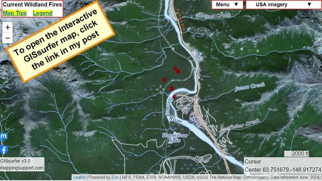
#RileyFire in #Denali National Park and Preserve, Alaska.
This is burning across the Nenana River from the park village.

Map shows heat detections from MODIS and VIIRS satellites. Locations are approximate and not real time. #AKfire #Wildfire #AlaskaWX

Open GISsurfer map:
https://mappingsupport.com/p2/gissurfer.php?center=63.751679,-148.917274&zoom=13&basemap=USA_imagery&overlay=State_boundary,MODIS_7_day,VIIRS_7_day,Wildland_fire_name,Lake_river_stream,USA_roads&data=https://mappingsupport.com/p2/special_maps/disaster/USA_wildland_fire.txt

GISsurfer General Purpose Web Map and GIS Viewer | Surf GIS DATA

GISsurfer lets you surf a nearly endless amount of GIS data. Click a layer in the GIS server's table of contents and that data appears on the map.

@BakerRL75 @mappingsupport Steep terrain there and the Nenana River roars through the canyon. Not an easy place to fight a wildfire
@AlaskaWx @BakerRL75 @mappingsupport As of 3:00pm, the fire is estimated to have grown to 300 acres.
Tour and transit bus services have been discontinued westbound. Public front-country facilities and trails have been closed, including the Denali Visitor Center. Day use visitors currently west of the park entrance area are being shuttled eastward.
Stay informed about Alaska’s current wildfires, red flag warnings, and more by visiting https://akfireinfo.com.
Alaska Wildland Fire Information

akfireinfo.com

Alaska Wildland Fire Information
@EyeOnAlaska @AlaskaWx @mappingsupport Posted. Will be looking for further updates and posting under #RileyFire
Denali National Park and Preserve

Denali National Park and Preserve. Gefällt 400.795 Mal · 3.834 Personen sprechen darüber · 279.822 waren hier. "In our thinking of McKinley let us not have puny thoughts." -- Biologist Adolph Murie