1) State of the Gazetteer in 2023:
10 years in and open data is winning!

Read my deep dive on the Who’s On First places gazetteer, including dozens of maps and tables...

https://whosonfirst.org/blog/2023/06/07/state-of-the-gazetteer/

🧵

State of the Gazetteer in 2023

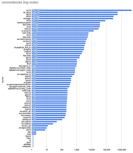
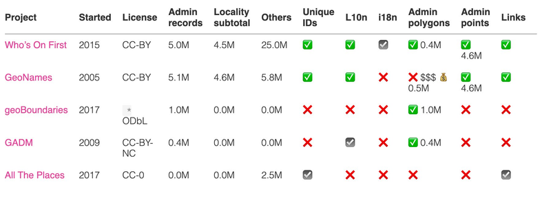
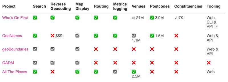
Since we launched in 2015, the Who's On First places gazetteer project has grown in coverage, complexity, and supported applications. In this this post I will summarize Who’s On First’s key advantages, offer a comparative analysis of WOF and other open gazetteers, quantify our global coverage by placetype, offer score cards by country, dive into name localization, look at internationalization through the lens of disputed territories, and quantify geometry types and sources of those polygon and points, hold hands with and thank our sources, and invite collaboration.

Who's On First
2) The Who’s On First (WOF) gazetteer is a big list of places, each with a stable identifier, and a set of common and optional descriptive properties about each location – including geometries.
3) The WOF gazetteer provides a single source of truth across a minimalist common set of placetypes, spanning the entire globe, and supplemented as-needed on a regional level
4) WOF’s focus on localities and unique identifiers sets us apart from many other projects.
5) WOF has global coverage for 5M (million) administrative places, including 4.5M localities. More than 25M additional places are available, including: 3.9M postal codes, 7K (thousand) constituencies, and 21M venues.
6) We choose to approach geography at a personal level – starting with the 🏙️🌇`locality` (or populated place) where people ⚽play, 📚study, 👩‍💻🏢work, and 🛌sleep – and 🇺🇳`countries` for when people need a 🛂passport to cross a frontier and experience something new and exciting.
7) Between those “top” and “bottom” placetypes, countries nest multiple subdivisions. Who’s On First aligns them into common “region” (1st order subdivisions, tracked by the ISO), “county” (2nd order subdivisions), and “localadmin” (municipalities) placetypes.
8) Of those features, 452K have detailed polygons, with complete coverage at country, region, and county placetypes and exhaustive coverage for localadmin and large localities in major industrialized economies, with exhaustive coverage as point geometries for remaining features.
9) We also store 447K alternate geometries – sometimes a different shaped polygon, or a nearby point location.
10) We’ve been at this for a while, so some of the data is from this year, and some of it was imported a while ago. Mapping a changing world means there’s always ongoing work.
11) WOF rates 87 countries w/ good to great polygon coverage at locality & parent administrative subdivisions in the A-AA-AAA-AAAA range. We rate 177 countries that are mostly limited to point locality coverage and basic polygon administrative subdivisions in the B-BB-BBB-BBBB range.
12) Names are localized into 494 languages, using internet standard language codes. The most common language in Who’s On First is English, followed by Chinese, and French. Rounding out the top 10 in ranked order are Russian, German, Dutch, Swedish, Spanish, Italian, and Polish.
13) Population values, min_zoom ranking, and polygon label centroids enable sophisticated map designs with beautiful and informative cartography
14) Internationalized with disputed territory boundaries for global audiences and compliance with local regulations (label points for the polygons shown in the map)

15) Includes original work and data aggregated from 360+ authoritative sources. Our source data licenses have been vetted by multiple corporate attorneys at large, publicly traded companies.

https://github.com/whosonfirst/whosonfirst-sources/blob/main/sources/README.md

whosonfirst-sources/README.md at main · whosonfirst/whosonfirst-sources

Where things come from in Who's On First. Contribute to whosonfirst/whosonfirst-sources development by creating an account on GitHub.

GitHub
16) WOF holds hands with 60+ datasets via linked unique identifiers to allow crosswalk across 6.5M feature-level concordances.

17) Who’s On First’s open license (CC-BY attribution) means you’re free to use the data for commercial purposes, including derivative rights, as long as you credit the project and our sources.

whosonfirst.org/docs/licenses/

18) Spelunker web app allows quick viewing of formatted records with a map and data tables. Write Field web editor allows for quick property edits with human review. Raw data can be viewed on Github.

- spelunker.whosonfirst.org/id/85921881/
- https://writefield.nextzen.org/place/edit?url=https://raw.githubusercontent.com/whosonfirst-data/whosonfirst-data-admin-us/master/data/859/775/39/85977539.geojson
- https://github.com/whosonfirst-data/whosonfirst-data-admin-us/blob/master/data/859/218/81/85921881.geojson

19) Who's On First is a collaborative project started @mapzen in 2015. The project remains active, including contributions from Snapchat, and is now hosted by the @linuxfoundation.
20) Like any product, Who’s On First is made by people, and we’ve collectively spent about “20 years” building WOF as an original work and as an aggregation of many other open data projects. Thanks to everyone in the #opendata movement!

21) Download the data in SQLite and Shapefile formats, distributions kindly hosted by Geocode.Earth (thanks!)

Read more in our recent blog post:

https://whosonfirst.org/blog/2023/05/31/shapefiles/

Making Who’s On First more accessible

Shapefiles improve accessibility to the Who's On First gazetteer for GIS users for a core set of standard place response properties, and discussion of making simple edits, bulk imports, and knowledge sharing in our community.

Who's On First
@kelsoscorner thank you for the excellent data collection!