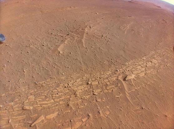
Ingenuity imaged part of the "Curvilinear Unit" in Jezero delta during flight 46. These bands are thought to be ancient sandbars that might contain valuable insights into the geologic history of the delta.
Credit: NASA/JPL-Caltech/Simeon Schmauß

See this map by @65dBnoise:
https://mastodon.social/@65dBnoise/109941290071037305
#NASA #MarsHelicopter #Mars2020 #Solarorocks #Space

@stim3on @65dBnoise
Very nice work developing this image! This is, I believe, the best treatment of an RTE photo that I've seen. 🤓
@tom30519 @65dBnoise Thanks for the praise, it's a bunch of work to get these images to look good. I'm trying to automate it as best as possible but its almost impossible to make something that works across multiple flights.

@stim3on @65dBnoise
Indeed. There is a lot of variance, even among images from the same flight.

I've tried various approaches when I have the time, including luminance masks, etc., but what works for one file can be way out of the ballpark for the next!

But that we are getting anything useful at all from the colour camera after 46 flights and the months of frigid winter temperatures is pretty amazing!

@tom30519 @65dBnoise Yeah, it's incredible! I'm silently hoping they will come in with the rover and give the lens a good dust off with the Gas Dust Removal Tool (gDRT) on its robotic arm 💨
https://link.springer.com/article/10.1007/s11214-020-00783-7#Sec8
The Sampling and Caching Subsystem (SCS) for the Scientific Exploration of Jezero Crater by the Mars 2020 Perseverance Rover

@stim3on @65dBnoise

I wonder if AEGIS could be taught to recognize the heli, and thus be able to position the gDRT without knocking into poor Ingenuity. That would be a little risky!

At least move the rover into a position where Mastcam or SuperCam can see how much dust is stuck on the solar panel.

You'd think all this flying around would knock the dust off, but then it might collect again as the dust settles after landing.