The Globus INK (1967) is a remarkable piece of Soviet spacecraft equipment. Its rotating globe showed cosmonauts the position of their Soyuz spacecraft. An electromechanical analog computer, it used gears, cams, and differentials to compute the position. Let's look inside 🧵
The Globus used complex gear trains driven by solenoids to move the globe.
The globe uses a clever mechanism to rotate in two dimensions. Rotating along the dotted axis traces out the 51.8° orbit. Turning a concentric shaft causes the two halves of the globe to rotate around the polar axis, held by the fixed metal equator.
The spacecraft's initial position was entered into the Globus by turning the central knob, rotating the globe. The Globus did not receive any position input from an inertial measurement unit (IMU) but just projected the spacecraft's location from the initial value.
The orbital period could be adjusted ±5 minutes. Followers riding on a spiral cone cam turned at adjustable speeds based on their position, slow at the top, faster at the bottom. Three adjustments (minutes, tenths, and hundredths) were added by differential gears.
Latitude and longitude were displayed on indicators. They depended on complex trig functions, computed by specially-shaped cams. Coincidentally, the latitude indicator matches the Ukrainian flag. 🇺🇦
The globe showed geographical features as well as the boundaries of the USSR and politically-aligned regions. As well as tracking their position, cosmonauts could judge the safety of potential landing sites, both physically and politically.
But why does the globe have dots indicating NASA communication sites such as Goldstone, Bermuda, and Merritt Island? This Globus must be from the Apollo-Soyuz project (1975), where an Apollo spacecraft docked with Soyuz in orbit.
@kenshirriff I'm fascinated by #9, which is right at the intersection of Honduras, Guatemala, and Belize. The nearest big city near the mark is San Pedro Sula, Honduras. But the closet *soviet-aligned* country would be Nicaragua, even though the mar is really too far west for that. But in 2017 ROSCOSMOS opened a GLOSNASS station in Laguna de Nejapa, Nicaragua, so its not impossible there was earlier coordination.
@kenshirriff Diplomatic relations between Honduras and the USSR weren't established until 1990, and even today the nearest embassy is in Nicaragua; but there was until recently an "honorary consulate" on the outskirts of San Pedro Sula, at "Plaza de Metal. Colonia El Playón, 2ª planta (contiguo a la Alianza Francesa), Código postal: 21101, San Pedro Sula"
https://goo.gl/maps/f3PesfjhPJKeSNZ7A
Bevor Sie zu Google Maps weitergehen

@kenshirriff The third possibility is Guatemala (which still claims the territory of Belize) which has had diplomatic relations with Russia since 1945, and they were "frozen" but not interrupted at the time of Apollo-Soyuz in 1975. That part of Guatemala is pretty undeveloped, though. *Maybe* Puerto Barrios could have supported a tracking site?
@cscott Those are interesting suggestions. I did a bunch of web searching to try to figure out what #9 marks on the map but couldn't determine anything.
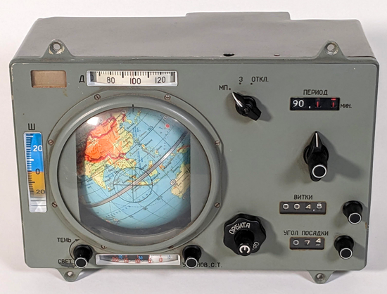
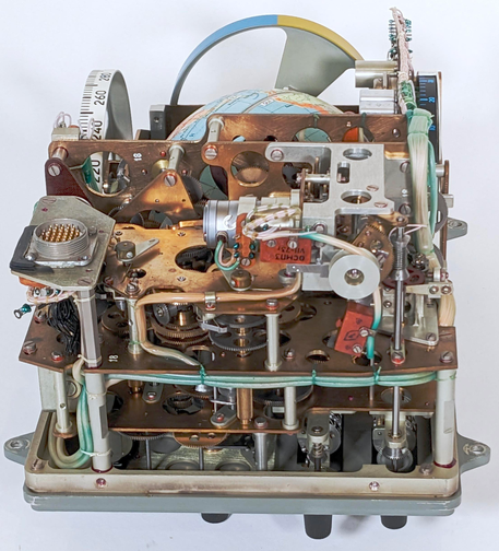
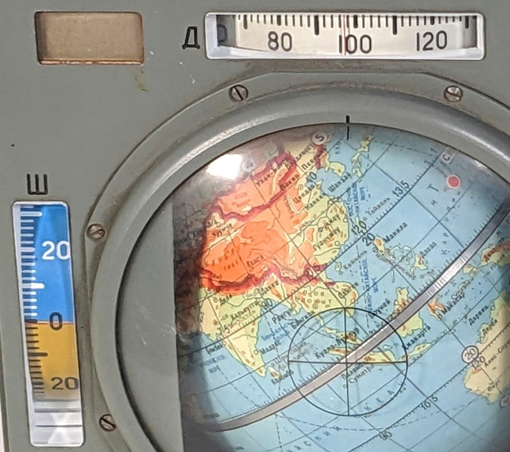
@kenshirriff Yes, me too. I lived in Guatemala and Honduras for a number of years growing up, and just judging from level of economic activity/ready availability of logistical support I'd say that San Pedro Sula is the most likely option. I'd love to take a look at the honorary consulate there and see if there are any remaining traces of a tracking dish, which must have been fairly large. I don't think the Puerto Barrios region in Guatemala could have supported the construction, transportation, and logistics needs of a large dish. On the other hand, if it was intended to be *covert*, then there is plenty of dense terrain there in which to hide a station, and it's *possible* you could ship large pieces in from the Caribbean port. That would be some spy-thriller stuff, though, and I can't imagine the three-letter agencies in the US would be too happy about the USSR operating heavy machinery covertly on our doorstep.