
Check out how land is used in the United States. Cows take up the most space!
https://www.bloomberg.com/graphics/2018-us-land-use/
First in a 🧵 of #2022TopToots

Check out how land is used in the United States. Cows take up the most space!
https://www.bloomberg.com/graphics/2018-us-land-use/
First in a 🧵 of #2022TopToots
This map shows only people. It is a beautiful illustration of where people are concentrated.
If you squint, you can see Australia and New Zealand.
Map by Alasdair Rae https://www.visualcapitalist.com/cp/3d-map
Third in a 🧵 of #2022TopToots

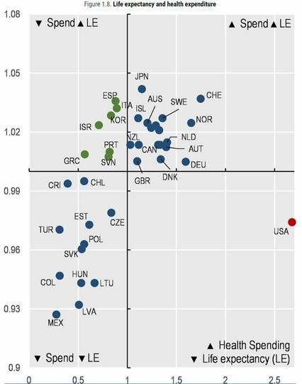
Check out this scatterplot of health spending per capita (x axis) & life expectancy (y axis) in OECD countries (lines = averages).
The United States sits alone in the bottom right quadrant due to its much higher spending and below-average life expectancy.
More info: https://oecd-ilibrary.org/sites/ae3016b9-en/1/3/1/index.html?itemId=/content/publication/ae3016b9-en&_csp_=ca413da5d44587bc56446341952c275e&itemIGO=oecd&itemContentType=book
Fourth in a 🧵of #2022TopToots
@conradhackett guess why?
#Healthcare isn't seen as a #HumanRight, but a #commodity in the #USA.
That's why #MedicalDebt is rampant and why the life expectancy is declining there as well...


