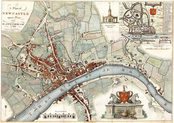
Don't ya just love an old map of the place you live? What's still here? What's not there yet? Found this 1788 map of Newcastle, which shows the old streets that have been there a LONG time, like Northumberland St, Percy St, Pilgrim St, Westgate etc. Their very names tell of their age. What's missing are the not yet built Grey Street and Grainger Street, and of course, the railway. Fascinating.
A little surprised to see what's now called Cut Bank and Byker Bank, out to the east, crossing the Ouseburn are there. Cool.
And Gateshead, though a very old settlement, since Roman times, and mentioned by Bede in the 7th century, is still at this point, apparently mostly just focused around the Great North Road and spreading out along the river a bit.
It's also of course very strange to see only one bridge crossing the Tyne there! We're currently up to 7. Or 9 if you count the ones along at Scotswood.
Make that 10 - I forgot about the old railway bridge at Scotswood.
More thoughts occurring to me as a look at it - that thick black line that's not a road - that's the city walls. Only a few bits of them are still there today. Note the gates in them. Note what's outside them, including Gallowgate. I'm sure you can guess what used to happen there. (The football ground is there now and the south end of the stadium is called the Gallowgate end.)
@beecycling I got some reproduction early 20th century OS maps of the area I'm using as a basis for a steampunk-ish story & found out there used to be a gas works near the centre of town - it was a car park when I was a kid & is now a shopping centre, but explains why that bit of land hasn't been used for housing!